National Register of Historic Places listings in Worth County, Georgia
This is a list of properties and districts in Worth County, Georgia that are listed on the National Register of Historic Places (NRHP).
Map all coordinates using OpenStreetMap
Download coordinates as:
- KML
- GPX (all coordinates)
- GPX (primary coordinates)
- GPX (secondary coordinates)
This National Park Service list is complete through NPS recent listings posted August 30, 2024.[1]
- v
- t
- e
Properties on the National Register of Historic Places in Georgia by county
- Appling
- Atkinson
- Bacon
- Baker
- Baldwin
- Banks
- Barrow
- Bartow
- Ben Hill
- Berrien
- Bibb
- Bleckley
- Brantley
- Brooks
- Bryan
- Bulloch
- Burke
- Butts
- Calhoun
- Camden
- Candler
- Carroll
- Catoosa
- Charlton
- Chatham
- Chattahoochee
- Chattooga
- Cherokee
- Clarke
- Clay
- Clayton
- Clinch
- Cobb
- Coffee
- Colquitt
- Columbia
- Cook
- Coweta
- Crawford
- Crisp
- Dade
- Dawson
- Decatur
- DeKalb
- Dodge
- Dooly
- Dougherty
- Douglas
- Early
- Echols
- Effingham
- Elbert
- Emanuel
- Evans
- Fannin
- Fayette
- Floyd
- Forsyth
- Franklin
- Fulton
- Gilmer
- Glascock
- Glynn
- Gordon
- Grady
- Greene
- Gwinnett
- Habersham
- Hall
- Hancock
- Haralson
- Harris
- Hart
- Heard
- Henry
- Houston
- Irwin
- Jackson
- Jasper
- Jeff Davis
- Jefferson
- Jenkins
- Johnson
- Jones
- Lamar
- Lanier
- Laurens
- Lee
- Liberty
- Lincoln
- Long
- Lowndes
- Lumpkin
- Macon
- Madison
- Marion
- McDuffie
- McIntosh
- Meriwether
- Miller
- Mitchell
- Monroe
- Montgomery
- Morgan
- Murray
- Muscogee
- Newton
- Oconee
- Oglethorpe
- Paulding
- Peach
- Pickens
- Pierce
- Pike
- Polk
- Pulaski
- Putnam
- Quitman
- Rabun
- Randolph
- Richmond
- Rockdale
- Schley
- Screven
- Seminole
- Spalding
- Stephens
- Stewart
- Sumter
- Talbot
- Taliaferro
- Tattnall
- Taylor
- Telfair
- Terrell
- Thomas
- Tift
- Toombs
- Towns
- Treutlen
- Troup
- Turner
- Twiggs
- Union
- Upson
- Walker
- Walton
- Ware
- Warren
- Washington
- Wayne
- Webster
- Wheeler
- White
- Whitfield
- Wilcox
- Wilkes
- Wilkinson
- Worth

Current listings
| [2] | Name on the Register | Image | Date listed[3] | Location | City or town | Description |
|---|---|---|---|---|---|---|
| 1 | Possum Poke | 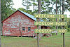 | August 26, 1982 (#82002499) | US 82 31°31′02″N 83°46′55″W / 31.517222°N 83.781944°W / 31.517222; -83.781944 (Possum Poke) | Poulan | Now owned by Abraham Baldwin Agricultural College |
| 2 | Poulan Library | 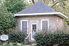 | July 25, 2003 (#03000679) | S side of 100 block of Church St., across from the church 31°30′48″N 83°47′18″W / 31.513222°N 83.788222°W / 31.513222; -83.788222 (Poulan Library) | Poulan | Built in 1908 |
| 3 | Sumner High School | 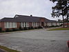 | September 27, 1996 (#96001035) | 716 Walnut St. 31°30′33″N 83°44′08″W / 31.509167°N 83.735556°W / 31.509167; -83.735556 (Sumner High School) | Sumner | |
| 4 | Sylvester Commercial Historic District |  | July 9, 1987 (#87001153) | Bounded by E. Kelly, N. Main, E. Front, and N. Isabella Sts. (original) and approx. the jct. of Main St. and Liberty St., (increase) 31°31′36″N 83°50′16″W / 31.526667°N 83.837778°W / 31.526667; -83.837778 (Sylvester Commercial Historic District) | Sylvester | Second set of boundaries represents a boundary increase of May 9, 2002 |
| 5 | US Post Office-Sylvester |  | July 5, 1996 (#96000735) | 122 N. Main St. 31°31′37″N 83°50′06″W / 31.526944°N 83.835°W / 31.526944; -83.835 (US Post Office-Sylvester) | Sylvester | Built 1937-39 |
| 6 | Worth County Courthouse |  | September 18, 1980 (#80001268) | Courthouse Sq. 31°31′41″N 83°50′09″W / 31.52793°N 83.83595°W / 31.52793; -83.83595 (Worth County Courthouse) | Sylvester | Built 1905 |
| 7 | Worth County Local Building | 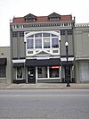 | August 21, 1980 (#80001269) | 118 N. Isabella St. 31°31′38″N 83°50′15″W / 31.527222°N 83.8375°W / 31.527222; -83.8375 (Worth County Local Building) | Sylvester | Built 1911 |
References
- ^ National Park Service, United States Department of the Interior, "National Register of Historic Places: Weekly List Actions", retrieved August 30, 2024.
- ^ Numbers represent an alphabetical ordering by significant words. Various colorings, defined here, differentiate National Historic Landmarks and historic districts from other NRHP buildings, structures, sites or objects.
- ^ The eight-digit number below each date is the number assigned to each location in the National Register Information System database, which can be viewed by clicking the number.
Wikimedia Commons has media related to National Register of Historic Places in Worth County, Georgia.


