National Register of Historic Places listings in Stephens County, Georgia
This is a list of properties and districts in Stephens County, Georgia that are listed on the National Register of Historic Places (NRHP).
Map all coordinates using OpenStreetMap
Download coordinates as:
- KML
- GPX (all coordinates)
- GPX (primary coordinates)
- GPX (secondary coordinates)
This National Park Service list is complete through NPS recent listings posted August 30, 2024.[1]
- v
- t
- e
Properties on the National Register of Historic Places in Georgia by county
- Appling
- Atkinson
- Bacon
- Baker
- Baldwin
- Banks
- Barrow
- Bartow
- Ben Hill
- Berrien
- Bibb
- Bleckley
- Brantley
- Brooks
- Bryan
- Bulloch
- Burke
- Butts
- Calhoun
- Camden
- Candler
- Carroll
- Catoosa
- Charlton
- Chatham
- Chattahoochee
- Chattooga
- Cherokee
- Clarke
- Clay
- Clayton
- Clinch
- Cobb
- Coffee
- Colquitt
- Columbia
- Cook
- Coweta
- Crawford
- Crisp
- Dade
- Dawson
- Decatur
- DeKalb
- Dodge
- Dooly
- Dougherty
- Douglas
- Early
- Echols
- Effingham
- Elbert
- Emanuel
- Evans
- Fannin
- Fayette
- Floyd
- Forsyth
- Franklin
- Fulton
- Gilmer
- Glascock
- Glynn
- Gordon
- Grady
- Greene
- Gwinnett
- Habersham
- Hall
- Hancock
- Haralson
- Harris
- Hart
- Heard
- Henry
- Houston
- Irwin
- Jackson
- Jasper
- Jeff Davis
- Jefferson
- Jenkins
- Johnson
- Jones
- Lamar
- Lanier
- Laurens
- Lee
- Liberty
- Lincoln
- Long
- Lowndes
- Lumpkin
- Macon
- Madison
- Marion
- McDuffie
- McIntosh
- Meriwether
- Miller
- Mitchell
- Monroe
- Montgomery
- Morgan
- Murray
- Muscogee
- Newton
- Oconee
- Oglethorpe
- Paulding
- Peach
- Pickens
- Pierce
- Pike
- Polk
- Pulaski
- Putnam
- Quitman
- Rabun
- Randolph
- Richmond
- Rockdale
- Schley
- Screven
- Seminole
- Spalding
- Stephens
- Stewart
- Sumter
- Talbot
- Taliaferro
- Tattnall
- Taylor
- Telfair
- Terrell
- Thomas
- Tift
- Toombs
- Towns
- Treutlen
- Troup
- Turner
- Twiggs
- Union
- Upson
- Walker
- Walton
- Ware
- Warren
- Washington
- Wayne
- Webster
- Wheeler
- White
- Whitfield
- Wilcox
- Wilkes
- Wilkinson
- Worth

Current listings
| [2] | Name on the Register | Image | Date listed[3] | Location | City or town | Description |
|---|---|---|---|---|---|---|
| 1 | Eastanollee Auditorium | 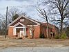 | March 31, 2000 (#00000301) | Northeastern corner of the junction of Eastanollee School Rd. and Red Hollow Rd. 34°32′20″N 83°15′19″W / 34.538889°N 83.255278°W / 34.538889; -83.255278 (Eastanollee Auditorium) | Eastanollee | |
| 2 | Jarrett-Hayes House | 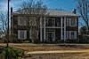 | June 10, 1994 (#94000572) | Northeastern side of County Route 3, about 2 miles east of its junction with State Route 184 34°37′42″N 83°15′32″W / 34.628333°N 83.258889°W / 34.628333; -83.258889 (Jarrett-Hayes House) | Toccoa | |
| 3 | Martin Historic District | 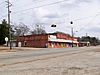 | July 7, 1995 (#95000825) | Along both sides of State Route 17 and the Hartwell RR railroad tracks 34°29′10″N 83°11′07″W / 34.486111°N 83.185278°W / 34.486111; -83.185278 (Martin Historic District) | Martin | |
| 4 | Riverside |  | September 21, 1982 (#82002465) | North of Toccoa on Georgia State Route 184 34°38′26″N 83°17′17″W / 34.640556°N 83.288056°W / 34.640556; -83.288056 (Riverside) | Toccoa | |
| 5 | Schaefer-Marks House |  | December 12, 1976 (#76000647) | 316 E. Doyle St. 34°34′44″N 83°19′35″W / 34.578889°N 83.326389°W / 34.578889; -83.326389 (Schaefer-Marks House) | Toccoa | |
| 6 | James B. Simmons House | 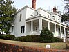 | April 7, 1983 (#83000241) | 130 W. Tugalo St. 34°34′50″N 83°19′53″W / 34.580556°N 83.331389°W / 34.580556; -83.331389 (James B. Simmons House) | Toccoa | |
| 7 | Stephens County Courthouse |  | September 18, 1980 (#80001232) | Courthouse Sq. 34°34′47″N 83°19′51″W / 34.579722°N 83.330833°W / 34.579722; -83.330833 (Stephens County Courthouse) | Toccoa | |
| 8 | Toccoa Downtown Historic District | 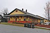 | December 6, 2011 (#11000879) | Roughly bounded by Alexander, Currahee, Hill, & Savannah Sts.; also 118 W. Doyle St. 34°34′45″N 83°19′44″W / 34.57927°N 83.328847°W / 34.57927; -83.328847 (Toccoa Downtown Historic District) | Toccoa | W. Doyle St. address represents a boundary increase, September 22, 2015. |
| 9 | Traveler's Rest | 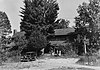 | October 15, 1966 (#66000283) | East of Toccoa on U.S. Route 123 34°36′33″N 83°14′20″W / 34.60926°N 83.23878°W / 34.60926; -83.23878 (Traveler's Rest) | Toccoa | National Historic Landmark and a Georgia state historic site |
| 10 | Walters-Davis House | Upload image | June 17, 1982 (#82002464) | 429 E. Tugalo St. 34°34′49″N 83°19′28″W / 34.580278°N 83.324444°W / 34.580278; -83.324444 (Walters-Davis House) | Toccoa |
References
- ^ National Park Service, United States Department of the Interior, "National Register of Historic Places: Weekly List Actions", retrieved August 30, 2024.
- ^ Numbers represent an alphabetical ordering by significant words. Various colorings, defined here, differentiate National Historic Landmarks and historic districts from other NRHP buildings, structures, sites or objects.
- ^ The eight-digit number below each date is the number assigned to each location in the National Register Information System database, which can be viewed by clicking the number.
Wikimedia Commons has media related to National Register of Historic Places in Stephens County, Georgia.


