National Register of Historic Places listings in Muscogee County, Georgia

This is a list of properties and districts in Muscogee County, Georgia that are listed on the National Register of Historic Places (NRHP).
Map all coordinates using OpenStreetMap
Download coordinates as:
- KML
- GPX (all coordinates)
- GPX (primary coordinates)
- GPX (secondary coordinates)
This National Park Service list is complete through NPS recent listings posted August 30, 2024.[1]
Current listings
| [2] | Name on the Register | Image | Date listed[3] | Location | City or town | Description |
|---|---|---|---|---|---|---|
| 1 | 1238 Professional Building | Upload image | July 1, 2022 (#100007851) | 1238 2nd Ave. 32°28′13″N 84°59′25″W / 32.4702°N 84.9903°W / 32.4702; -84.9903 (1238 Professional Building) | Columbus | |
| 2 | Adams Cotton Gin Building |  | May 17, 1984 (#84001205) | 6601 Hamilton Rd. 32°32′26″N 84°57′18″W / 32.540556°N 84.955°W / 32.540556; -84.955 (Adams Cotton Gin Building) | Columbus | Removed between 2008 and 2009 |
| 3 | George O. Berry House | Upload image | September 29, 1980 (#80001124) | 912 2nd Ave. 32°27′48″N 84°59′24″W / 32.463458°N 84.990026°W / 32.463458; -84.990026 (George O. Berry House) | Columbus | |
| 4 | Bibb City Historic District | Upload image | February 24, 2010 (#10000037) | Roughly bounded by Chattahoochee River, Woodland Cir., 2nd Ave. and 35th St. 32°30′08″N 84°59′30″W / 32.502347°N 84.991686°W / 32.502347; -84.991686 (Bibb City Historic District) | Bibb City | |
| 5 | Broad Street Methodist Episcopal Church South | Upload image | December 2, 1980 (#80001125) | 1323-1325 Broadway 32°28′17″N 84°59′37″W / 32.471389°N 84.993611°W / 32.471389; -84.993611 (Broad Street Methodist Episcopal Church South) | Columbus | Removed |
| 6 | Building at 1007 Broadway | 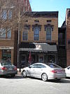 | September 29, 1980 (#80001130) | 1007 Broadway 32°27′55″N 84°59′37″W / 32.465145°N 84.993619°W / 32.465145; -84.993619 (Building at 1007 Broadway) | Columbus | |
| 7 | Building at 1009 Broadway |  | September 29, 1980 (#80001131) | 1009 Broadway 32°27′55″N 84°59′37″W / 32.465236°N 84.993563°W / 32.465236; -84.993563 (Building at 1009 Broadway) | Columbus | |
| 8 | Building at 1400 Third Avenue |  | September 29, 1980 (#80001132) | 1400 Third Ave. 32°28′21″N 84°59′20″W / 32.4725°N 84.988889°W / 32.4725; -84.988889 (Building at 1400 Third Avenue) | Columbus | |
| 9 | Building at 1519 3rd Avenue | Upload image | December 2, 1980 (#80001126) | 1519 3rd Ave. 32°28′30″N 84°59′21″W / 32.475°N 84.989167°W / 32.475; -84.989167 (Building at 1519 3rd Avenue) | Columbus | Removed |
| 10 | Building at 1531 3rd Avenue | Upload image | December 2, 1980 (#80001127) | 1531 3rd Ave. 32°28′32″N 84°59′21″W / 32.475536°N 84.989276°W / 32.475536; -84.989276 (Building at 1531 3rd Avenue) | Columbus | |
| 11 | Building at 1612 3rd Avenue | Upload image | December 2, 1980 (#80001128) | 1612 3rd Ave. 32°28′35″N 84°59′20″W / 32.476389°N 84.988889°W / 32.476389; -84.988889 (Building at 1612 3rd Avenue) | Columbus | Removed |
| 12 | Building at 1617 Third Avenue | Upload image | September 29, 1980 (#80001137) | 1617 Third Ave. 32°28′37″N 84°59′21″W / 32.477037°N 84.989247°W / 32.477037; -84.989247 (Building at 1617 Third Avenue) | Columbus | |
| 13 | Building at 1619 Third Avenue | Upload image | September 29, 1980 (#80001138) | 1619 Third Ave. 32°28′38″N 84°59′21″W / 32.477112°N 84.989264°W / 32.477112; -84.989264 (Building at 1619 Third Avenue) | Columbus | |
| 14 | Building at 1625 Third Avenue | Upload image | September 29, 1980 (#80001139) | 1625 Third Ave. 32°28′38″N 84°59′21″W / 32.477220°N 84.989281°W / 32.477220; -84.989281 (Building at 1625 Third Avenue) | Columbus | |
| 15 | Building at 215 Ninth Street | Upload image | September 29, 1980 (#80001140) | 215 Ninth St. 32°27′47″N 84°59′22″W / 32.463086°N 84.989578°W / 32.463086; -84.989578 (Building at 215 Ninth Street) | Columbus | |
| 16 | Building at 221 Ninth Street | Upload image | September 29, 1980 (#80001141) | 221 Ninth St. 32°27′47″N 84°59′22″W / 32.463078°N 84.989334°W / 32.463078; -84.989334 (Building at 221 Ninth Street) | Columbus | |
| 17 | Building at 303 11th St. | Upload image | December 2, 1980 (#80001129) | 303 11th St. 32°28′00″N 84°59′20″W / 32.466667°N 84.988889°W / 32.466667; -84.988889 (Building at 303 11th St.) | Columbus | Removed |
| 18 | Building at 920 Ninth Avenue | Upload image | September 29, 1980 (#80001142) | 920 Ninth Ave. 32°27′45″N 84°58′48″W / 32.462471°N 84.980088°W / 32.462471; -84.980088 (Building at 920 Ninth Avenue) | Columbus | |
| 19 | Building at 921 Fifth Avenue | Upload image | September 29, 1980 (#80001143) | 921 Fifth Ave. 32°27′50″N 84°59′12″W / 32.463934°N 84.986603°W / 32.463934; -84.986603 (Building at 921 Fifth Avenue) | Columbus | |
| 20 | Building at 944 Second Avenue | Upload image | September 29, 1980 (#80001144) | 944 Second Ave. 32°27′52″N 84°59′25″W / 32.464444°N 84.990278°W / 32.464444; -84.990278 (Building at 944 Second Avenue) | Columbus | Removed |
| 21 | Bullard-Hart House |  | July 28, 1977 (#77000439) | 1408 3rd Ave. 32°28′23″N 84°59′20″W / 32.473056°N 84.988889°W / 32.473056; -84.988889 (Bullard-Hart House) | Columbus | |
| 22 | Bush-Philips Hardware Co. |  | December 2, 1980 (#80001145) | 1025 Broadway 32°27′56″N 84°59′37″W / 32.465556°N 84.993611°W / 32.465556; -84.993611 (Bush-Philips Hardware Co.) | Columbus | |
| 23 | Thomas U. Butts House |  | September 29, 1980 (#80001146) | 1214 3rd Ave. 32°28′09″N 84°59′20″W / 32.469167°N 84.988889°W / 32.469167; -84.988889 (Thomas U. Butts House) | Columbus | |
| 24 | C.S.S. Muscogee and Chattahoochee (gunboats) |  | May 13, 1970 (#70000212) | 4th St. W of U.S. 27 32°26′49″N 84°58′46″W / 32.446851°N 84.979511°W / 32.446851; -84.979511 (C.S.S. Muscogee and Chattahoochee (gunboats)) | Columbus | CSS Chattahoochee and CSS Muscogee |
| 25 | Walter Hurt Cargill House | Upload image | September 29, 1980 (#80001147) | 1415 3rd Ave. 32°28′22″N 84°59′22″W / 32.472778°N 84.989444°W / 32.472778; -84.989444 (Walter Hurt Cargill House) | Columbus | |
| 26 | Carter and Bradley, Cotton Factors and Warehouseman | 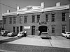 | December 2, 1980 (#80001148) | 1001-1037 Front Ave. 32°27′56″N 84°59′42″W / 32.465556°N 84.995°W / 32.465556; -84.995 (Carter and Bradley, Cotton Factors and Warehouseman) | Columbus | |
| 27 | The Cedars | 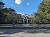 | November 23, 1971 (#71000282) | 2039 13th St. 32°28′20″N 84°57′48″W / 32.472222°N 84.963333°W / 32.472222; -84.963333 (The Cedars) | Columbus | |
| 28 | Central of Georgia Railroad Terminal | Upload image | December 2, 1980 (#80001150) | 700 12th St. 32°28′07″N 84°59′01″W / 32.468611°N 84.983611°W / 32.468611; -84.983611 (Central of Georgia Railroad Terminal) | Columbus | Removed |
| 29 | Central of Georgia Railroad Terminal |  | September 29, 1980 (#80001149) | 1200 6th Ave. 32°28′07″N 84°59′01″W / 32.468611°N 84.983611°W / 32.468611; -84.983611 (Central of Georgia Railroad Terminal) | Columbus | |
| 30 | Church of the Holy Family |  | September 29, 1980 (#80001152) | 320 12th St. 32°28′06″N 84°59′18″W / 32.468333°N 84.988333°W / 32.468333; -84.988333 (Church of the Holy Family) | Columbus | |
| 31 | Church Square | Upload image | December 2, 1980 (#80001151) | Roughly bounded by 2nd and 3rd Aves., 11th and 12th Sts. 32°28′03″N 84°59′23″W / 32.4675°N 84.989722°W / 32.4675; -84.989722 (Church Square) | Columbus | |
| 32 | City Fire Department |  | September 29, 1980 (#80001153) | 1338 and 1340 Broadway 32°28′19″N 84°59′35″W / 32.471944°N 84.993056°W / 32.471944; -84.993056 (City Fire Department) | Columbus | |
| 33 | Claflin School | Upload image | November 24, 2015 (#15000813) | 1532 5th Ave. 32°28′33″N 84°59′07″W / 32.4757°N 84.9854°W / 32.4757; -84.9854 (Claflin School) | Columbus | |
| 34 | Cole-Hatcher-Hampton Wholesale Grocers | Upload image | September 29, 1980 (#80001154) | 22 W. 10 St. 32°27′54″N 84°59′40″W / 32.465009°N 84.994326°W / 32.465009; -84.994326 (Cole-Hatcher-Hampton Wholesale Grocers) | Columbus | |
| 35 | Colored Cemetery aka Porterdale Cemetery | Upload image | September 29, 1980 (#80001155) | 10th Ave. 32°27′11″N 84°58′54″W / 32.453056°N 84.981667°W / 32.453056; -84.981667 (Colored Cemetery aka Porterdale Cemetery) | Columbus | |
| 36 | Columbian Lodge No. 7 Free and Accepted Masons | Upload image | September 29, 1980 (#80001156) | 101 12th St. 32°28′07″N 84°59′30″W / 32.468611°N 84.991667°W / 32.468611; -84.991667 (Columbian Lodge No. 7 Free and Accepted Masons) | Columbus | |
| 37 | Columbus Coca-Cola Bottling Company | Upload image | August 22, 2022 (#100008016) | 1147 6th Ave. 32°28′04″N 84°59′06″W / 32.4679°N 84.9850°W / 32.4679; -84.9850 (Columbus Coca-Cola Bottling Company) | Columbus | |
| 38 | Columbus High School | Upload image | September 29, 1980 (#80001157) | 320 11th St. 32°27′59″N 84°59′17″W / 32.466389°N 84.988056°W / 32.466389; -84.988056 (Columbus High School) | Columbus | Columbus High School no longer occupies building |
| 39 | Columbus Historic District |  | July 29, 1969 (#69000045) | Roughly bounded by 9th and 4th Sts., 4th Ave., and the Chattahoochee River Boundary increase (listed October 21, 1988, refnum 88002048): Bounded by Ninth and Fourth Sts., Chattahoochee River and Fourth Ave. 32°27′29″N 84°59′32″W / 32.458056°N 84.992222°W / 32.458056; -84.992222 (Columbus Historic District) | Columbus | |
| 40 | Columbus Historic Riverfront Industrial District |  | June 2, 1978 (#78000995) | Columbus River from 8th St. N. to 38th St. 32°29′08″N 84°59′31″W / 32.485553°N 84.992017°W / 32.485553; -84.992017 (Columbus Historic Riverfront Industrial District) | Columbus | National Historic Landmark |
| 41 | Columbus Investment Company Building | Upload image | September 29, 1980 (#80001158) | 21 12th St. 32°28′07″N 84°59′32″W / 32.468611°N 84.992222°W / 32.468611; -84.992222 (Columbus Investment Company Building) | Columbus | |
| 42 | Columbus Ironworks | 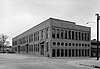 | July 29, 1969 (#69000046) | 901 Front Ave. 32°27′47″N 84°59′43″W / 32.463056°N 84.995278°W / 32.463056; -84.995278 (Columbus Ironworks) | Columbus | |
| 43 | Columbus Manufacturing Company |  | July 10, 2007 (#07000699) | 3201 1st Ave. 32°29′40″N 84°59′29″W / 32.49435°N 84.991297°W / 32.49435; -84.991297 (Columbus Manufacturing Company) | Columbus | |
| 44 | Columbus Stockade | Upload image | December 2, 1980 (#80001159) | 622 10th St. 32°27′52″N 84°59′02″W / 32.464444°N 84.983889°W / 32.464444; -84.983889 (Columbus Stockade) | Columbus | |
| 45 | Wm. L. Cooke House | Upload image | December 2, 1980 (#80001210) | 1523 3rd Ave. 32°28′31″N 84°59′21″W / 32.475278°N 84.989167°W / 32.475278; -84.989167 (Wm. L. Cooke House) | Columbus | |
| 46 | William H. Denson House |  | September 29, 1980 (#80001162) | 930 5th Ave. 32°27′50″N 84°59′10″W / 32.463889°N 84.986111°W / 32.463889; -84.986111 (William H. Denson House) | Columbus | Removed |
| 47 | Depot Business Buildings | Upload image | September 29, 1980 (#80001163) | 519, 521 and 523 E. 12th St. 32°28′08″N 84°59′06″W / 32.468804°N 84.985116°W / 32.468804; -84.985116 (Depot Business Buildings) | Columbus | |
| 48 | Dinglewood |  | February 1, 1972 (#72000389) | 1429 Dinglewood St. 32°28′07″N 84°58′19″W / 32.468611°N 84.971944°W / 32.468611; -84.971944 (Dinglewood) | Columbus | An Italian Villa style house built in 1859 |
| 49 | Dinglewood Historic District |  | November 21, 2001 (#01001248) | Bounded by 13th and 16th Ave., 13th St., and Wynnton Rd. 32°28′08″N 84°58′14″W / 32.468753°N 84.970486°W / 32.468753; -84.970486 (Dinglewood Historic District) | Columbus | A historic district |
| 50 | Robert E. Dismukes Sr. House |  | January 8, 1979 (#79000736) | 1617 Summit Dr. 32°28′34″N 84°57′46″W / 32.476111°N 84.962778°W / 32.476111; -84.962778 (Robert E. Dismukes Sr. House) | Columbus | |
| 51 | Elisha P. Dismukes House | Upload image | December 2, 1980 (#80001164) | 1515 3rd Ave. 32°28′29″N 84°59′21″W / 32.474722°N 84.989167°W / 32.474722; -84.989167 (Elisha P. Dismukes House) | Columbus | Lost to fire |
| 52 | First African Baptist Church |  | September 29, 1980 (#80001165) | 901 5th Ave. 32°27′46″N 84°59′12″W / 32.462778°N 84.986667°W / 32.462778; -84.986667 (First African Baptist Church) | Columbus | |
| 53 | First African Baptist Church Parsonage | 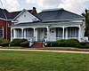 | September 29, 1980 (#80001166) | 911 5th Ave. 32°27′47″N 84°59′12″W / 32.463056°N 84.986667°W / 32.463056; -84.986667 (First African Baptist Church Parsonage) | Columbus | |
| 54 | First National Bank |  | November 1, 1974 (#74000697) | 1048 Broadway 32°27′59″N 84°59′34″W / 32.466527°N 84.992877°W / 32.466527; -84.992877 (First National Bank) | Columbus | |
| 55 | First Presbyterian Church |  | September 29, 1980 (#80001167) | 1100 1st Ave. 32°28′00″N 84°59′30″W / 32.466667°N 84.991667°W / 32.466667; -84.991667 (First Presbyterian Church) | Columbus | |
| 56 | John T. Fletcher House | Upload image | September 29, 1980 (#80001168) | 311 11th St. 32°28′00″N 84°59′19″W / 32.466667°N 84.988611°W / 32.466667; -84.988611 (John T. Fletcher House) | Columbus | Removed |
| 57 | Fontaine Building | Upload image | September 29, 1980 (#80001169) | 13 W. 11th St. 32°27′59″N 84°59′39″W / 32.466389°N 84.994167°W / 32.466389; -84.994167 (Fontaine Building) | Columbus | |
| 58 | Fortson House | 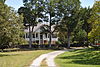 | June 3, 1999 (#99000657) | 1100 Fortson Rd. 32°36′24″N 84°56′07″W / 32.6067966°N 84.935203°W / 32.6067966; -84.935203 (Fortson House) | Fortson | |
| 59 | Frank Brothers | Upload image | December 2, 1980 (#80001170) | 18 W. 10th St. 32°27′54″N 84°59′39″W / 32.464981°N 84.994202°W / 32.464981; -84.994202 (Frank Brothers) | Columbus | |
| 60 | Gann's Pharmacy | Upload image | September 29, 1980 (#80001171) | 1611 2nd Ave. 32°28′36″N 84°59′26″W / 32.476667°N 84.990556°W / 32.476667; -84.990556 (Gann's Pharmacy) | Columbus | Removed |
| 61 | Garrett-Bullock House | Upload image | September 29, 1980 (#80001172) | 1402 2nd Ave. 32°28′21″N 84°59′25″W / 32.4725°N 84.990278°W / 32.4725; -84.990278 (Garrett-Bullock House) | Columbus | |
| 62 | Girard Colored Mission | Upload image | September 29, 1980 (#80001173) | 1002 6th Ave. 32°27′55″N 84°59′04″W / 32.465348°N 84.984527°W / 32.465348; -84.984527 (Girard Colored Mission) | Columbus | |
| 63 | Goetchius-Wellborn House |  | July 29, 1969 (#69000047) | 405 Broadway 32°27′14″N 84°59′38″W / 32.453889°N 84.993889°W / 32.453889; -84.993889 (Goetchius-Wellborn House) | Columbus | |
| 64 | Golden Brothers, Founders and Machinists | Upload image | September 29, 1980 (#80001174) | 600 12th St. 32°28′04″N 84°59′05″W / 32.467778°N 84.984722°W / 32.467778; -84.984722 (Golden Brothers, Founders and Machinists) | Columbus | |
| 65 | Green Island Ranch | Upload image | February 7, 1997 (#97000030) | 6551 Green Island Dr. 32°32′31″N 85°00′11″W / 32.541944°N 85.003056°W / 32.541944; -85.003056 (Green Island Ranch) | Columbus | |
| 66 | Harrison-Gibson House | Upload image | September 29, 1980 (#80001175) | 309 11th St. 32°28′00″N 84°59′19″W / 32.466667°N 84.988611°W / 32.466667; -84.988611 (Harrison-Gibson House) | Columbus | Removed |
| 67 | High Uptown Historic District | Upload image | July 7, 2004 (#04000669) | Roughly bounded by 2nd and 3rd Aves. between Railroad and 13th Sts. 32°28′25″N 84°59′22″W / 32.473611°N 84.989444°W / 32.473611; -84.989444 (High Uptown Historic District) | Columbus | |
| 68 | Highland Hall | Upload image | April 1, 1980 (#80004459) | 1504 17th St. 32°28′42″N 84°58′12″W / 32.478275°N 84.969904°W / 32.478275; -84.969904 (Highland Hall) | Columbus | |
| 69 | Hillcrest-Wildwood Circle Historic District | Upload image | July 14, 2002 (#02001748) | Roughly bounded by Wildwood Ave., 13th and 17th Sts., and Dixon Dr. 32°28′31″N 84°57′21″W / 32.475278°N 84.955833°W / 32.475278; -84.955833 (Hillcrest-Wildwood Circle Historic District) | Columbus | |
| 70 | Hilton |  | January 20, 1972 (#72000390) | 2505 Macon Rd. 32°28′24″N 84°57′14″W / 32.473333°N 84.953889°W / 32.473333; -84.953889 (Hilton) | Columbus | |
| 71 | Hofflin & Greentree Building |  | September 30, 1982 (#82002457) | 1128-1130 Broadway 32°28′04″N 84°59′35″W / 32.467778°N 84.993056°W / 32.467778; -84.993056 (Hofflin & Greentree Building) | Columbus | |
| 72 | Illges House | Upload image | June 19, 1973 (#73000634) | 1428 2nd Ave. 32°28′25″N 84°59′24″W / 32.473584°N 84.989928°W / 32.473584; -84.989928 (Illges House) | Columbus | |
| 73 | John Paul Illges House |  | September 29, 1980 (#80001178) | 1425 3rd Ave. 32°28′24″N 84°59′21″W / 32.473333°N 84.989167°W / 32.473333; -84.989167 (John Paul Illges House) | Columbus | |
| 74 | Isaac Maund House | Upload image | December 2, 1980 (#80001179) | 1608 3rd Ave. 32°28′35″N 84°59′20″W / 32.476389°N 84.988889°W / 32.476389; -84.988889 (Isaac Maund House) | Columbus | Home no longer exists. |
| 75 | Joseph House |  | July 29, 1969 (#69000048) | 828 Broadway 32°27′44″N 84°59′35″W / 32.462222°N 84.993056°W / 32.462222; -84.993056 (Joseph House) | Columbus | |
| 76 | Kress | 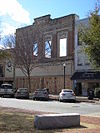 | September 29, 1980 (#80001180) | 1117 Broadway 32°28′02″N 84°59′37″W / 32.467222°N 84.993611°W / 32.467222; -84.993611 (Kress) | Columbus | Building destroyed by fire in 1994. Facade was saved and remains standing. |
| 77 | Abraham Lafkowitz House | Upload image | September 29, 1980 (#80001181) | 934 5th Ave. 32°27′51″N 84°59′10″W / 32.464167°N 84.986111°W / 32.464167; -84.986111 (Abraham Lafkowitz House) | Columbus | Removed |
| 78 | Ledger-Enquirer Building | 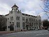 | December 2, 1980 (#80001183) | 17 W. 12th St. 32°28′06″N 84°59′40″W / 32.468333°N 84.994444°W / 32.468333; -84.994444 (Ledger-Enquirer Building) | Columbus | |
| 79 | Lewis-Rothchild Building | Upload image | March 26, 2004 (#04000239) | 1214 First Ave. 32°28′08″N 84°59′30″W / 32.468889°N 84.991667°W / 32.468889; -84.991667 (Lewis-Rothchild Building) | Columbus | |
| 80 | Liberty Theater |  | May 22, 1984 (#84001208) | 821 8th Ave. 32°27′42″N 84°58′58″W / 32.461667°N 84.982778°W / 32.461667; -84.982778 (Liberty Theater) | Columbus | |
| 81 | Lion House |  | January 20, 1972 (#72000391) | 1316 3rd Ave. 32°28′16″N 84°59′22″W / 32.471111°N 84.989444°W / 32.471111; -84.989444 (Lion House) | Columbus | |
| 82 | Sol Loeb Building-Garrett-Joy Building |  | March 15, 2005 (#05000141) | 900 Front Ave. and 901 Broadway 32°27′46″N 84°59′37″W / 32.462778°N 84.993611°W / 32.462778; -84.993611 (Sol Loeb Building-Garrett-Joy Building) | Muscogee | |
| 83 | McArdle House | 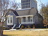 | September 29, 1980 (#80001184) | 927 3rd Ave. 32°27′49″N 84°59′22″W / 32.463611°N 84.989444°W / 32.463611; -84.989444 (McArdle House) | Columbus | |
| 84 | McGehee-Woodall House | Upload image | January 20, 1972 (#72000392) | 1534 2nd Ave. 32°28′33″N 84°59′26″W / 32.475833°N 84.990556°W / 32.475833; -84.990556 (McGehee-Woodall House) | Columbus | Removed |
| 85 | Methodist Tabernacle | Upload image | September 29, 1980 (#80001186) | 1605 3rd Ave. 32°28′34″N 84°59′22″W / 32.476111°N 84.989444°W / 32.476111; -84.989444 (Methodist Tabernacle) | Columbus | |
| 86 | Mott House |  | December 3, 1974 (#74000698) | Front Ave. 32°28′22″N 84°59′39″W / 32.472778°N 84.994167°W / 32.472778; -84.994167 (Mott House) | Columbus | Destroyed by fire September 8, 2014. |
| 87 | Mott--Fox--Huguley House | Upload image | March 12, 2012 (#12000093) | 2027 6th Avenue 32°29′03″N 84°59′09″W / 32.484131°N 84.985948°W / 32.484131; -84.985948 (Mott--Fox--Huguley House) | Columbus | |
| 88 | Octagon House | 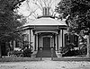 | July 29, 1969 (#69000049) | 527 1st Ave. 32°27′23″N 84°59′32″W / 32.4562674°N 84.992257°W / 32.4562674; -84.992257 (Octagon House) | Columbus | National Historic Landmark |
| 89 | Old City Cemetery |  | September 29, 1980 (#80001188) | Linwood Blvd. 32°28′39″N 84°59′00″W / 32.4775°N 84.983333°W / 32.4775; -84.983333 (Old City Cemetery) | Columbus | |
| 90 | Old Dawson Place | Upload image | January 8, 1979 (#79000737) | 1420 Wynnton Rd. 32°27′59″N 84°58′17″W / 32.4663885°N 84.971461°W / 32.4663885; -84.971461 (Old Dawson Place) | Columbus | |
| 91 | Peabody-Warner House |  | December 29, 1970 (#70000213) | 1445 2nd Ave. 32°28′26″N 84°59′27″W / 32.473889°N 84.990833°W / 32.473889; -84.990833 (Peabody-Warner House) | Columbus | |
| 92 | Peacock Woods-Dimon Circle Historic District | Upload image | March 26, 2003 (#03000134) | Bounded by Cherokee and Forest Aves. and 13th and 17 Sts. 32°28′31″N 84°57′47″W / 32.475278°N 84.963056°W / 32.475278; -84.963056 (Peacock Woods-Dimon Circle Historic District) | Columbus | |
| 93 | Pemberton House |  | September 28, 1971 (#71000283) | 11 7th St. 32°27′33″N 84°59′34″W / 32.459167°N 84.992778°W / 32.459167; -84.992778 (Pemberton House) | Columbus | |
| 94 | George Phillips House | Upload image | September 29, 1980 (#80001190) | 1406 3rd Ave. 32°28′22″N 84°59′20″W / 32.472778°N 84.988889°W / 32.472778; -84.988889 (George Phillips House) | Columbus | |
| 95 | George Pond House |  | September 29, 1980 (#80001191) | 922 2nd Ave. 32°27′49″N 84°59′26″W / 32.463611°N 84.990556°W / 32.463611; -84.990556 (George Pond House) | Columbus | |
| 96 | Power and Baird, Wholesale Dry Goods and Notions | Upload image | December 2, 1980 (#80001193) | 1107 Broadway 32°28′01″N 84°59′37″W / 32.466944°N 84.993611°W / 32.466944; -84.993611 (Power and Baird, Wholesale Dry Goods and Notions) | Columbus | |
| 97 | Gertrude Ma Pridgett Rainey House | 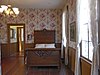 | November 18, 1992 (#92001530) | 805 5th Ave. 32°27′41″N 84°59′12″W / 32.461389°N 84.986667°W / 32.461389; -84.986667 (Gertrude Ma Pridgett Rainey House) | Columbus | |
| 98 | Rankin House |  | March 16, 1972 (#72000393) | 1440 2nd Ave. 32°28′20″N 84°59′25″W / 32.472222°N 84.990278°W / 32.472222; -84.990278 (Rankin House) | Columbus | |
| 99 | Rankin Square | Upload image | October 7, 1977 (#77000440) | Bounded by Broadway, 1st Ave., 10th and 11th Sts. 32°27′56″N 84°59′34″W / 32.465556°N 84.992778°W / 32.465556; -84.992778 (Rankin Square) | Columbus | |
| 100 | Reich Dry Goods Company | Upload image | April 1, 2004 (#04000240) | 14 W 11th St. 32°28′01″N 84°59′39″W / 32.466884°N 84.994074°W / 32.466884; -84.994074 (Reich Dry Goods Company) | Columbus | |
| 101 | Ridgewood | Upload image | April 2, 1980 (#80001215) | Jenkins Rd. 32°33′19″N 84°44′26″W / 32.555278°N 84.740556°W / 32.555278; -84.740556 (Ridgewood) | Upatoi | |
| 102 | John Spencer Roberts House | Upload image | September 29, 1980 (#80001195) | 927 5th Ave. 32°27′50″N 84°59′12″W / 32.463889°N 84.986667°W / 32.463889; -84.986667 (John Spencer Roberts House) | Columbus | |
| 103 | Rose Hill School | Upload image | March 30, 2022 (#100007533) | 433 21st St. 32°29′04″N 84°59′10″W / 32.4844°N 84.9861°W / 32.4844; -84.9861 (Rose Hill School) | Columbus | |
| 104 | Max Rosenberg House | Upload image | September 29, 1980 (#80001196) | 1011 3rd Ave. 32°27′54″N 84°59′22″W / 32.465°N 84.989444°W / 32.465; -84.989444 (Max Rosenberg House) | Columbus | |
| 105 | David Rothschild's Wholesale Dry Goods | Upload image | September 29, 1980 (#80001197) | 1029 Broadway 32°27′57″N 84°59′37″W / 32.465833°N 84.993611°W / 32.465833; -84.993611 (David Rothschild's Wholesale Dry Goods) | Columbus | |
| 106 | David Rothschild House | Upload image | September 29, 1980 (#80001198) | 1220 3rd Ave. 32°28′10″N 84°59′20″W / 32.469444°N 84.988889°W / 32.469444; -84.988889 (David Rothschild House) | Columbus | Removed |
| 107 | Secondary Industrial School | 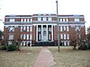 | April 9, 1980 (#80001199) | 1112 29th St. 32°29′21″N 84°58′41″W / 32.489167°N 84.978056°W / 32.489167; -84.978056 (Secondary Industrial School) | Columbus | |
| 108 | Silver's Five and Dime Store-H.L. Green Co. | Upload image | August 4, 2005 (#05000794) | 1101-1103 Broadway 32°28′01″N 84°59′37″W / 32.4668782°N 84.99372°W / 32.4668782; -84.99372 (Silver's Five and Dime Store-H.L. Green Co.) | Columbus | |
| 109 | Sixteenth Street School | Upload image | September 29, 1980 (#80001200) | 1532 3rd Ave. 32°28′33″N 84°59′20″W / 32.475833°N 84.988889°W / 32.475833; -84.988889 (Sixteenth Street School) | Columbus | |
| 110 | Southern Railway Freight Depot | Upload image | August 21, 1997 (#97000922) | 1300 6th Ave. 32°28′17″N 84°59′05″W / 32.471389°N 84.984722°W / 32.471389; -84.984722 (Southern Railway Freight Depot) | Columbus | |
| 111 | William Henry Spencer House | Upload image | May 23, 1978 (#78000996) | 745 4th Ave. 32°27′39″N 84°59′17″W / 32.46074°N 84.98798°W / 32.46074; -84.98798 (William Henry Spencer House) | Columbus | |
| 112 | Springer Opera House |  | December 29, 1970 (#70000214) | 105 10th St. 32°27′54″N 84°59′29″W / 32.46513°N 84.99134°W / 32.46513; -84.99134 (Springer Opera House) | Columbus | National Historic Landmark |
| 113 | St. Christoper's Normal and Industrial Parish School |  | September 29, 1980 (#80001201) | 900 5th Ave. 32°27′46″N 84°59′10″W / 32.462778°N 84.986111°W / 32.462778; -84.986111 (St. Christoper's Normal and Industrial Parish School) | Columbus | Removed |
| 114 | St. Elmo |  | April 7, 1971 (#71000284) | 2810 St. Elmo Dr. 32°29′21″N 84°57′58″W / 32.489167°N 84.966111°W / 32.489167; -84.966111 (St. Elmo) | Columbus | |
| 115 | St. John Chapel |  | September 29, 1980 (#80001202) | 1516 5th Ave. 32°28′29″N 84°59′10″W / 32.474722°N 84.986111°W / 32.474722; -84.986111 (St. John Chapel) | Columbus | |
| 116 | Swift Manufacturing Company | Upload image | September 10, 2014 (#14000173) | 1410 6th St. 32°28′27″N 84°59′04″W / 32.4740569°N 84.984432°W / 32.4740569; -84.984432 (Swift Manufacturing Company) | Columbus | |
| 117 | Swift-Kyle House |  | April 11, 1973 (#73000635) | 303 12th St. 32°28′09″N 84°59′20″W / 32.469167°N 84.988889°W / 32.469167; -84.988889 (Swift-Kyle House) | Columbus | |
| 118 | C. B. Tarver Building | Upload image | August 4, 2005 (#05000793) | 18-23 W. 11th St. 32°28′01″N 84°59′40″W / 32.4668662°N 84.994322°W / 32.4668662; -84.994322 (C. B. Tarver Building) | Columbus | |
| 119 | Alma Thomas House | 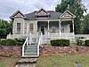 | October 20, 2009 (#09000270) | 411 21st St. 32°29′04″N 84°59′13″W / 32.484386°N 84.986967°W / 32.484386; -84.986967 (Alma Thomas House) | Columbus | |
| 120 | Triangle Building |  | September 29, 1980 (#80001204) | 1330 Broadway 32°28′17″N 84°59′35″W / 32.471389°N 84.993056°W / 32.471389; -84.993056 (Triangle Building) | Columbus | Removed |
| 121 | Trinity Episcopal Church |  | September 29, 1980 (#80001205) | 1130 1st Ave. 32°28′03″N 84°59′30″W / 32.4675°N 84.991667°W / 32.4675; -84.991667 (Trinity Episcopal Church) | Columbus | |
| 122 | Charles E. Turner House | Upload image | September 29, 1980 (#80001206) | 909 3rd Ave. 32°27′48″N 84°59′22″W / 32.463333°N 84.989444°W / 32.463333; -84.989444 (Charles E. Turner House) | Columbus | |
| 123 | U.S. Post Office and Courthouse | 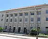 | September 29, 1980 (#80001207) | 120 12th St. 32°28′06″N 84°59′27″W / 32.468333°N 84.990833°W / 32.468333; -84.990833 (U.S. Post Office and Courthouse) | Columbus | |
| 124 | W. Jacob Burrus House | Upload image | December 2, 1980 (#80001208) | 307 11th St. 32°28′00″N 84°59′20″W / 32.466667°N 84.988889°W / 32.466667; -84.988889 (W. Jacob Burrus House) | Columbus | Removed |
| 125 | Walker-Peters-Langdon House |  | July 29, 1969 (#69000050) | 716 Broadway 32°27′36″N 84°59′41″W / 32.46°N 84.994722°W / 32.46; -84.994722 (Walker-Peters-Langdon House) | Columbus | |
| 126 | Waverly Terrace | Upload image | December 1, 1983 (#83003598) | Roughly bounded by Hamilton Rd., Peabody Ave., 27th and 30th Sts. 32°29′23″N 84°58′44″W / 32.489722°N 84.978889°W / 32.489722; -84.978889 (Waverly Terrace) | Columbus | |
| 127 | Wells-Bagley House | Upload image | July 29, 1969 (#69000051) | 22 6th St. 32°27′25″N 84°59′32″W / 32.456908°N 84.992201°W / 32.456908; -84.992201 (Wells-Bagley House) | Columbus | |
| 128 | Weracoba-St. Elmo Historic District |  | July 1, 1994 (#94000665) | Roughly bounded by 13th and Virginia Sts., 13th, 15th, 16th and Cherokee Aves. and Talbotton Rd. 32°28′51″N 84°58′05″W / 32.480833°N 84.968056°W / 32.480833; -84.968056 (Weracoba-St. Elmo Historic District) | Muscogee | |
| 129 | Wolfson Printing and Paper Co. | Upload image | December 2, 1980 (#80001211) | 24 W. 10th St. 32°27′54″N 84°59′40″W / 32.464959°N 84.99444°W / 32.464959; -84.99444 (Wolfson Printing and Paper Co.) | Columbus | |
| 130 | Ernest Woodruff House | Upload image | September 29, 1980 (#80001212) | 1414 2nd Ave. 32°28′22″N 84°59′25″W / 32.472778°N 84.990278°W / 32.472778; -84.990278 (Ernest Woodruff House) | Columbus | |
| 131 | Henry Lindsay Woodruff House | Upload image | December 2, 1980 (#80001176) | 1535 3rd Ave. 32°28′32″N 84°59′21″W / 32.475556°N 84.989167°W / 32.475556; -84.989167 (Henry Lindsay Woodruff House) | Columbus | |
| 132 | Henry Lindsay Woodruff Second House | Upload image | September 29, 1980 (#80001213) | 1420 2nd Ave. 32°28′23″N 84°59′25″W / 32.473056°N 84.990278°W / 32.473056; -84.990278 (Henry Lindsay Woodruff Second House) | Columbus | |
| 133 | John W. Woolfolk House | Upload image | January 22, 1979 (#79000738) | 1615 12th St. 32°28′07″N 84°58′06″W / 32.468611°N 84.968333°W / 32.468611; -84.968333 (John W. Woolfolk House) | Columbus | |
| 134 | Wynn House | Upload image | February 1, 1972 (#72000394) | 1240 Wynnton Rd. 32°27′57″N 84°58′28″W / 32.465833°N 84.974444°W / 32.465833; -84.974444 (Wynn House) | Columbus | |
| 135 | Wynn's Hill-Overlook-Oak Circle Historic District | Upload image | May 10, 2005 (#05000403) | Roughly bounded by Bradley Rd., Buena Vista Rd., Overlook Ave., Crest Dr., and Oakview Ave. 32°27′53″N 84°58′14″W / 32.464722°N 84.970556°W / 32.464722; -84.970556 (Wynn's Hill-Overlook-Oak Circle Historic District) | Columbus | |
| 136 | Wynnton Academy | 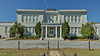 | April 11, 1972 (#72000395) | 2303 Wynnton Rd. 32°28′16″N 84°57′31″W / 32.4710972°N 84.958660°W / 32.4710972; -84.958660 (Wynnton Academy) | Columbus | |
| 137 | Wynnton Village Historic District | Upload image | June 22, 2005 (#05000622) | Roughly bounded by Wildwood Ave., Forest Ave., 18th St., 13th St., 16th ave. Wynnton Rd. 32°28′22″N 84°57′49″W / 32.472778°N 84.963611°W / 32.472778; -84.963611 (Wynnton Village Historic District) | Columbus | |
| 138 | Wynnwood |  | January 20, 1972 (#72000396) | 1846 Buena Vista Rd. 32°27′56″N 84°57′57″W / 32.465556°N 84.965833°W / 32.465556; -84.965833 (Wynnwood) | Columbus | Also known as "The Elms" |
| 139 | Y.M.C.A. | Upload image | September 29, 1980 (#80001214) | 124 11th St. 32°27′59″N 84°59′27″W / 32.466389°N 84.990833°W / 32.466389; -84.990833 (Y.M.C.A.) | Columbus |
Former listings
| [2] | Name on the Register | Image | Date listed | Date removed | Location | City or town | Description |
|---|---|---|---|---|---|---|---|
| 1 | Building at 1429 Second Avenue | Upload image | September 29, 1980 (#80001133) | July 7, 2004 | 1429 Second Avenue | Columbus | Demolished in 1988 |
| 2 | Building at 1520 Second Avenue | Upload image | September 29, 1980 (#80001134) | July 7, 2004 | 1520 Second Avenue | Columbus | Demolished in 1988 |
| 3 | Building at 1524 Second Avenue | Upload image | September 29, 1980 (#80001135) | July 7, 2004 | 1524 Second Avenue | Columbus | Demolished in 1988 |
| 4 | Building at 1606 Third Avenue | Upload image | September 29, 1980 (#80001136) | July 7, 2004 | 1606 Third Avenue | Columbus | Demolished in 1988 |
| 5 | Walter W. Curtis House | Upload image | September 29, 1980 (#80001160) | July 7, 2004 | 1427 Second Ave | Columbus | Demolished in 1988 |
| 6 | John T. Davis House | Upload image | September 29, 1980 (#80001161) | July 7, 2004 | 1526 Third Ave | Columbus | Demolished in 1988 |
| 7 | William P. Hunt House | Upload image | September 29, 1980 (#80001177) | July 7, 2004 | 1527 Second Ave 32°27′28″N 84°59′39″W / 32.457741°N 84.9943°W / 32.457741; -84.9943 (William P. Hunt House) | Columbus | Relocated to 612 Front Avenue in 1988. |
| 8 | John Lecroy House | Upload image | September 29, 1980 (#80001182) | July 7, 2004 | 1640 Third Ave | Columbus | Demolished in 1988 |
| 9 | Patrick J. McSorley House | Upload image | September 29, 1980 (#80001185) | July 7, 2004 | 1500 Second Ave | Columbus | Demolished in 1988 |
| 10 | Charles Mischke House | Upload image | September 29, 1980 (#80001187) | July 7, 2004 | 1638 Third Ave | Columbus | Demolished in 1988 |
| 11 | George A. Pearce House | Upload image | September 29, 1980 (#80001189) | July 7, 2004 | 1519 Second Ave | Columbus | Demolished in 1988 |
| 12 | Joseph F. Pou Jr. House | Upload image | September 29, 1980 (#80001192) | July 7, 2004 | 1528 Second Ave 32°27′31″N 84°59′27″W / 32.458598°N 84.990797°W / 32.458598; -84.990797 (Joseph F. Pou Jr. House) | Columbus | Relocated to 639 Second Avenue in 1993. |
| 13 | William Price House | Upload image | September 29, 1980 (#80001192) | July 7, 2004 | 1620 Third Ave | Columbus | Demolished in 1988 |
| 14 | John Stewart House | Upload image | September 29, 1980 (#80001203) | July 7, 2004 | 1618 Third Ave. | Columbus | Demolished in 1988 |
| 15 | James A. Walton House |  | September 29, 1980 (#80001209) | July 7, 2004 | 1523 Second Ave. 32°27′27″N 84°59′40″W / 32.4574175°N 84.994367°W / 32.4574175; -84.994367 (James A. Walton House) | Columbus | Moved to 604 Front Avenue in 1988. |
See also
References
Wikimedia Commons has media related to National Register of Historic Places in Muscogee County, Georgia.
- ^ National Park Service, United States Department of the Interior, "National Register of Historic Places: Weekly List Actions", retrieved August 30, 2024.
- ^ a b Numbers represent an alphabetical ordering by significant words. Various colorings, defined here, differentiate National Historic Landmarks and historic districts from other NRHP buildings, structures, sites or objects.
- ^ The eight-digit number below each date is the number assigned to each location in the National Register Information System database, which can be viewed by clicking the number.
- v
- t
- e
Properties on the National Register of Historic Places in Georgia by county
- Appling
- Atkinson
- Bacon
- Baker
- Baldwin
- Banks
- Barrow
- Bartow
- Ben Hill
- Berrien
- Bibb
- Bleckley
- Brantley
- Brooks
- Bryan
- Bulloch
- Burke
- Butts
- Calhoun
- Camden
- Candler
- Carroll
- Catoosa
- Charlton
- Chatham
- Chattahoochee
- Chattooga
- Cherokee
- Clarke
- Clay
- Clayton
- Clinch
- Cobb
- Coffee
- Colquitt
- Columbia
- Cook
- Coweta
- Crawford
- Crisp
- Dade
- Dawson
- Decatur
- DeKalb
- Dodge
- Dooly
- Dougherty
- Douglas
- Early
- Echols
- Effingham
- Elbert
- Emanuel
- Evans
- Fannin
- Fayette
- Floyd
- Forsyth
- Franklin
- Fulton
- Gilmer
- Glascock
- Glynn
- Gordon
- Grady
- Greene
- Gwinnett
- Habersham
- Hall
- Hancock
- Haralson
- Harris
- Hart
- Heard
- Henry
- Houston
- Irwin
- Jackson
- Jasper
- Jeff Davis
- Jefferson
- Jenkins
- Johnson
- Jones
- Lamar
- Lanier
- Laurens
- Lee
- Liberty
- Lincoln
- Long
- Lowndes
- Lumpkin
- Macon
- Madison
- Marion
- McDuffie
- McIntosh
- Meriwether
- Miller
- Mitchell
- Monroe
- Montgomery
- Morgan
- Murray
- Muscogee
- Newton
- Oconee
- Oglethorpe
- Paulding
- Peach
- Pickens
- Pierce
- Pike
- Polk
- Pulaski
- Putnam
- Quitman
- Rabun
- Randolph
- Richmond
- Rockdale
- Schley
- Screven
- Seminole
- Spalding
- Stephens
- Stewart
- Sumter
- Talbot
- Taliaferro
- Tattnall
- Taylor
- Telfair
- Terrell
- Thomas
- Tift
- Toombs
- Towns
- Treutlen
- Troup
- Turner
- Twiggs
- Union
- Upson
- Walker
- Walton
- Ware
- Warren
- Washington
- Wayne
- Webster
- Wheeler
- White
- Whitfield
- Wilcox
- Wilkes
- Wilkinson
- Worth


