National Register of Historic Places listings in Jones County, Georgia
This is a list of properties and districts in Jones County, Georgia that are listed on the National Register of Historic Places (NRHP).
Map all coordinates using OpenStreetMap
Download coordinates as:
- KML
- GPX (all coordinates)
- GPX (primary coordinates)
- GPX (secondary coordinates)
This National Park Service list is complete through NPS recent listings posted August 30, 2024.[1]
- v
- t
- e
Properties on the National Register of Historic Places in Georgia by county
- Appling
- Atkinson
- Bacon
- Baker
- Baldwin
- Banks
- Barrow
- Bartow
- Ben Hill
- Berrien
- Bibb
- Bleckley
- Brantley
- Brooks
- Bryan
- Bulloch
- Burke
- Butts
- Calhoun
- Camden
- Candler
- Carroll
- Catoosa
- Charlton
- Chatham
- Chattahoochee
- Chattooga
- Cherokee
- Clarke
- Clay
- Clayton
- Clinch
- Cobb
- Coffee
- Colquitt
- Columbia
- Cook
- Coweta
- Crawford
- Crisp
- Dade
- Dawson
- Decatur
- DeKalb
- Dodge
- Dooly
- Dougherty
- Douglas
- Early
- Echols
- Effingham
- Elbert
- Emanuel
- Evans
- Fannin
- Fayette
- Floyd
- Forsyth
- Franklin
- Fulton
- Gilmer
- Glascock
- Glynn
- Gordon
- Grady
- Greene
- Gwinnett
- Habersham
- Hall
- Hancock
- Haralson
- Harris
- Hart
- Heard
- Henry
- Houston
- Irwin
- Jackson
- Jasper
- Jeff Davis
- Jefferson
- Jenkins
- Johnson
- Jones
- Lamar
- Lanier
- Laurens
- Lee
- Liberty
- Lincoln
- Long
- Lowndes
- Lumpkin
- Macon
- Madison
- Marion
- McDuffie
- McIntosh
- Meriwether
- Miller
- Mitchell
- Monroe
- Montgomery
- Morgan
- Murray
- Muscogee
- Newton
- Oconee
- Oglethorpe
- Paulding
- Peach
- Pickens
- Pierce
- Pike
- Polk
- Pulaski
- Putnam
- Quitman
- Rabun
- Randolph
- Richmond
- Rockdale
- Schley
- Screven
- Seminole
- Spalding
- Stephens
- Stewart
- Sumter
- Talbot
- Taliaferro
- Tattnall
- Taylor
- Telfair
- Terrell
- Thomas
- Tift
- Toombs
- Towns
- Treutlen
- Troup
- Turner
- Twiggs
- Union
- Upson
- Walker
- Walton
- Ware
- Warren
- Washington
- Wayne
- Webster
- Wheeler
- White
- Whitfield
- Wilcox
- Wilkes
- Wilkinson
- Worth

Current listings
| [2] | Name on the Register | Image | Date listed[3] | Location | City or town | Description |
|---|---|---|---|---|---|---|
| 1 | Cabaniss-Hanberry House |  | January 1, 1976 (#76000639) | NE of Bradley on Transquilla Rd. 33°05′54″N 83°33′05″W / 33.098333°N 83.551389°W / 33.098333; -83.551389 (Cabaniss-Hanberry House) | Bradley | |
| 2 | Cabiness-Hunt House | Upload image | May 2, 1975 (#75000598) | SE of Round Oak off GA 11 33°05′16″N 83°31′48″W / 33.087778°N 83.53°W / 33.087778; -83.53 (Cabiness-Hunt House) | Round Oak | Note: the house is probably closer to 33.1107N, 83.6144W |
| 3 | Lemuel and Mary James House |  | May 14, 2013 (#13000271) | 153 James Rd. 32°58′01″N 83°28′26″W / 32.967042°N 83.47392°W / 32.967042; -83.47392 (Lemuel and Mary James House) | James | Built ca. 1885 |
| 4 | Jarrell Plantation | 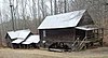 | May 9, 1973 (#73000624) | 6 mi. E of East Juliette off Dames Ferry Rd. 33°03′07″N 83°43′30″W / 33.051944°N 83.725°W / 33.051944; -83.725 (Jarrell Plantation) | East Juliette | Well-preserved "middle class" plantation, a Georgia State Historic Site |
| 5 | Jones County Courthouse |  | September 18, 1980 (#80001102) | GA 49 33°00′30″N 83°32′12″W / 33.00823°N 83.53659°W / 33.00823; -83.53659 (Jones County Courthouse) | Gray | |
| 6 | Jones County High School | 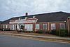 | May 12, 1999 (#99000555) | Clinton St. 33°00′27″N 83°32′18″W / 33.00753°N 83.5384°W / 33.00753; -83.5384 (Jones County High School) | Gray | Now the W.E. Knox Civic Center |
| 7 | Old Clinton Historic District | 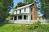 | September 12, 1974 (#74000690) | Runs along US 129 and SR 11 32°59′48″N 83°33′32″W / 32.996667°N 83.558889°W / 32.996667; -83.558889 (Old Clinton Historic District) | Clinton | |
| 8 | Roberts-Bush-Roberts House |  | June 30, 2015 (#15000361) | 157 Eatonton Hwy. 33°00′52″N 83°31′58″W / 33.0144°N 83.5327°W / 33.0144; -83.5327 (Roberts-Bush-Roberts House) | Gray | description[usurped] |
| 9 | Herman and Allene Shaver House |  | October 9, 2013 (#13000813) | 1421 Monticello Hwy. 33°03′35″N 83°36′19″W / 33.059608°N 83.605185°W / 33.059608; -83.605185 (Herman and Allene Shaver House) | Wayside |
References
Wikimedia Commons has media related to National Register of Historic Places in Jones County, Georgia.
- ^ National Park Service, United States Department of the Interior, "National Register of Historic Places: Weekly List Actions", retrieved August 30, 2024.
- ^ Numbers represent an alphabetical ordering by significant words. Various colorings, defined here, differentiate National Historic Landmarks and historic districts from other NRHP buildings, structures, sites or objects.
- ^ The eight-digit number below each date is the number assigned to each location in the National Register Information System database, which can be viewed by clicking the number.
Municipalities and communities of Jones County, Georgia, United States | ||
|---|---|---|
County seat: Gray | ||
| Cities |  | |
| Unincorporated communities | ||
| Ghost town | ||
| ||


