National Register of Historic Places listings in Clay County, Georgia
This is a list of properties and districts in Clay County, Georgia that are listed on the National Register of Historic Places (NRHP).
Map all coordinates using OpenStreetMap
Download coordinates as:
- KML
- GPX (all coordinates)
- GPX (primary coordinates)
- GPX (secondary coordinates)
This National Park Service list is complete through NPS recent listings posted August 30, 2024.[1]
- v
- t
- e
Properties on the National Register of Historic Places in Georgia by county
- Appling
- Atkinson
- Bacon
- Baker
- Baldwin
- Banks
- Barrow
- Bartow
- Ben Hill
- Berrien
- Bibb
- Bleckley
- Brantley
- Brooks
- Bryan
- Bulloch
- Burke
- Butts
- Calhoun
- Camden
- Candler
- Carroll
- Catoosa
- Charlton
- Chatham
- Chattahoochee
- Chattooga
- Cherokee
- Clarke
- Clay
- Clayton
- Clinch
- Cobb
- Coffee
- Colquitt
- Columbia
- Cook
- Coweta
- Crawford
- Crisp
- Dade
- Dawson
- Decatur
- DeKalb
- Dodge
- Dooly
- Dougherty
- Douglas
- Early
- Echols
- Effingham
- Elbert
- Emanuel
- Evans
- Fannin
- Fayette
- Floyd
- Forsyth
- Franklin
- Fulton
- Gilmer
- Glascock
- Glynn
- Gordon
- Grady
- Greene
- Gwinnett
- Habersham
- Hall
- Hancock
- Haralson
- Harris
- Hart
- Heard
- Henry
- Houston
- Irwin
- Jackson
- Jasper
- Jeff Davis
- Jefferson
- Jenkins
- Johnson
- Jones
- Lamar
- Lanier
- Laurens
- Lee
- Liberty
- Lincoln
- Long
- Lowndes
- Lumpkin
- Macon
- Madison
- Marion
- McDuffie
- McIntosh
- Meriwether
- Miller
- Mitchell
- Monroe
- Montgomery
- Morgan
- Murray
- Muscogee
- Newton
- Oconee
- Oglethorpe
- Paulding
- Peach
- Pickens
- Pierce
- Pike
- Polk
- Pulaski
- Putnam
- Quitman
- Rabun
- Randolph
- Richmond
- Rockdale
- Schley
- Screven
- Seminole
- Spalding
- Stephens
- Stewart
- Sumter
- Talbot
- Taliaferro
- Tattnall
- Taylor
- Telfair
- Terrell
- Thomas
- Tift
- Toombs
- Towns
- Treutlen
- Troup
- Turner
- Twiggs
- Union
- Upson
- Walker
- Walton
- Ware
- Warren
- Washington
- Wayne
- Webster
- Wheeler
- White
- Whitfield
- Wilcox
- Wilkes
- Wilkinson
- Worth

Current listings
| [2] | Name on the Register | Image | Date listed[3] | Location | City or town | Description |
|---|---|---|---|---|---|---|
| 1 | Clay County Courthouse | 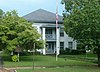 | September 18, 1980 (#80000992) | Off GA 37 31°36′15″N 85°02′54″W / 31.60422°N 85.04842°W / 31.60422; -85.04842 (Clay County Courthouse) | Fort Gaines | Two-story brick building which looks more like a plantation house than a courthouse. Part of the Fort Gaines Historic District. |
| 2 | Dill House |  | May 6, 1975 (#75000582) | 102 S. Washington St. 31°36′22″N 85°02′55″W / 31.6062°N 85.04848°W / 31.6062; -85.04848 (Dill House) | Fort Gaines | |
| 3 | Fort Gaines Cemetery Site | Upload image | December 16, 1974 (#74000669) | S of SR 37, W of Chattahoochee River 31°36′07″N 85°03′08″W / 31.601944°N 85.052222°W / 31.601944; -85.052222 (Fort Gaines Cemetery Site) | Fort Gaines | |
| 4 | Fort Gaines Historic District | | May 17, 1984 (#84000970) | Roughly bounded by Chattahoochee River, GA 37, GA 39, College, Commerce and Jefferson Sts. 31°36′27″N 85°03′02″W / 31.6075°N 85.050556°W / 31.6075; -85.050556 (Fort Gaines Historic District) | Fort Gaines | |
| 5 | Warren Sutton House | Upload image | March 24, 1994 (#93001571) | US 27 1000 ft. S of jct. with GA 37 at Sutton's Corners 31°35′50″N 84°50′41″W / 31.59711°N 84.84484°W / 31.59711; -84.84484 (Warren Sutton House) | Edison | |
| 6 | Toney-Standley House | Upload image | September 17, 1974 (#74000670) | NW of Fort Gaines off GA 39 31°42′55″N 85°05′20″W / 31.71528°N 85.089°W / 31.71528; -85.089 (Toney-Standley House) | Fort Gaines |
Former listings
| [2] | Name on the Register | Image | Date listed | Date removed | Location | City or town | Description |
|---|---|---|---|---|---|---|---|
| 1 | Walter F. George Dam Mound | Upload image | January 21, 1975 (#75000583) | August 1, 1986 | SE of Walter F. George Lock and Dam | Fort Gaines |
References
- ^ National Park Service, United States Department of the Interior, "National Register of Historic Places: Weekly List Actions", retrieved August 30, 2024.
- ^ a b Numbers represent an alphabetical ordering by significant words. Various colorings, defined here, differentiate National Historic Landmarks and historic districts from other NRHP buildings, structures, sites or objects.
- ^ The eight-digit number below each date is the number assigned to each location in the National Register Information System database, which can be viewed by clicking the number.
Wikimedia Commons has media related to National Register of Historic Places in Clay County, Georgia.
| |
|---|---|
| Topics | |
| Lists by state |
|
| Lists by insular areas | |
| Lists by associated state | |
| Other areas | |
| Related | |
| |


