National Register of Historic Places listings in Floyd County, Georgia

This is a list of properties and districts in Floyd County, Georgia that are listed on the National Register of Historic Places (NRHP).
Map all coordinates using OpenStreetMap
Download coordinates as:
- KML
- GPX (all coordinates)
- GPX (primary coordinates)
- GPX (secondary coordinates)
This National Park Service list is complete through NPS recent listings posted August 30, 2024.[1]
- v
- t
- e
Properties on the National Register of Historic Places in Georgia by county
- Appling
- Atkinson
- Bacon
- Baker
- Baldwin
- Banks
- Barrow
- Bartow
- Ben Hill
- Berrien
- Bibb
- Bleckley
- Brantley
- Brooks
- Bryan
- Bulloch
- Burke
- Butts
- Calhoun
- Camden
- Candler
- Carroll
- Catoosa
- Charlton
- Chatham
- Chattahoochee
- Chattooga
- Cherokee
- Clarke
- Clay
- Clayton
- Clinch
- Cobb
- Coffee
- Colquitt
- Columbia
- Cook
- Coweta
- Crawford
- Crisp
- Dade
- Dawson
- Decatur
- DeKalb
- Dodge
- Dooly
- Dougherty
- Douglas
- Early
- Echols
- Effingham
- Elbert
- Emanuel
- Evans
- Fannin
- Fayette
- Floyd
- Forsyth
- Franklin
- Fulton
- Gilmer
- Glascock
- Glynn
- Gordon
- Grady
- Greene
- Gwinnett
- Habersham
- Hall
- Hancock
- Haralson
- Harris
- Hart
- Heard
- Henry
- Houston
- Irwin
- Jackson
- Jasper
- Jeff Davis
- Jefferson
- Jenkins
- Johnson
- Jones
- Lamar
- Lanier
- Laurens
- Lee
- Liberty
- Lincoln
- Long
- Lowndes
- Lumpkin
- Macon
- Madison
- Marion
- McDuffie
- McIntosh
- Meriwether
- Miller
- Mitchell
- Monroe
- Montgomery
- Morgan
- Murray
- Muscogee
- Newton
- Oconee
- Oglethorpe
- Paulding
- Peach
- Pickens
- Pierce
- Pike
- Polk
- Pulaski
- Putnam
- Quitman
- Rabun
- Randolph
- Richmond
- Rockdale
- Schley
- Screven
- Seminole
- Spalding
- Stephens
- Stewart
- Sumter
- Talbot
- Taliaferro
- Tattnall
- Taylor
- Telfair
- Terrell
- Thomas
- Tift
- Toombs
- Towns
- Treutlen
- Troup
- Turner
- Twiggs
- Union
- Upson
- Walker
- Walton
- Ware
- Warren
- Washington
- Wayne
- Webster
- Wheeler
- White
- Whitfield
- Wilcox
- Wilkes
- Wilkinson
- Worth

Current listings
| [2] | Name on the Register | Image | Date listed[3] | Location | City or town | Description |
|---|---|---|---|---|---|---|
| 1 | Dr. Robert Battey House |  | June 17, 1982 (#82002414) | 725 E. 2nd Ave. 34°14′35″N 85°09′54″W / 34.243056°N 85.165°W / 34.243056; -85.165 (Dr. Robert Battey House) | Rome | |
| 2 | Berry Schools |  | July 21, 1978 (#78000981) | N of Rome on U.S. 27 34°18′27″N 85°12′49″W / 34.3075°N 85.213611°W / 34.3075; -85.213611 (Berry Schools) | Rome | |
| 3 | Between the Rivers Historic District |  | June 9, 1983 (#83000193) | Roughly bounded by the Etowah and Oostanaula Rivers, and 7th Ave. 34°15′06″N 85°10′16″W / 34.251667°N 85.171111°W / 34.251667; -85.171111 (Between the Rivers Historic District) | Rome | Historic district with more than 200 buildings, plus the Rome Clock Tower and a historic bridge. |
| 4 | John M. Carroll House | 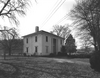 | June 19, 1980 (#80001021) | Park St. 34°06′09″N 85°20′23″W / 34.1025°N 85.339722°W / 34.1025; -85.339722 (John M. Carroll House) | Cave Spring | |
| 5 | Carroll-Harper House |  | June 19, 1980 (#80001023) | Cedartown St. 34°06′13″N 85°20′10″W / 34.103611°N 85.336111°W / 34.103611; -85.336111 (Carroll-Harper House) | Cave Spring | |
| 6 | Carroll-Richardson Grist Mill | Upload image | June 19, 1980 (#80001025) | Mill St. 34°06′04″N 85°20′27″W / 34.101111°N 85.340833°W / 34.101111; -85.340833 (Carroll-Richardson Grist Mill) | Cave Spring | |
| 7 | Cave Spring Commercial Historic District | 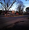 | June 19, 1980 (#80001028) | Alabama, Rome and Cedartown Rds., Broad and Padlock Sts. 34°06′27″N 85°20′11″W / 34.1075°N 85.336389°W / 34.1075; -85.336389 (Cave Spring Commercial Historic District) | Cave Spring | |
| 8 | Cave Spring Female Academy |  | June 19, 1980 (#80001030) | Rome St. 34°06′43″N 85°19′59″W / 34.111944°N 85.333056°W / 34.111944; -85.333056 (Cave Spring Female Academy) | Cave Spring | |
| 9 | Cave Spring High School | Upload image | June 19, 1980 (#80001032) | Rome St. 34°06′37″N 85°20′07″W / 34.110278°N 85.335278°W / 34.110278; -85.335278 (Cave Spring High School) | Cave Spring | Demolished |
| 10 | Cave Spring Railroad Station |  | June 19, 1980 (#80001034) | Alabama St. 34°06′28″N 85°20′32″W / 34.107778°N 85.342222°W / 34.107778; -85.342222 (Cave Spring Railroad Station) | Cave Spring | |
| 11 | Cave Spring Residential Historic District | Upload image | June 19, 1980 (#80001035) | U.S. 411 and GA 100 34°06′29″N 85°20′22″W / 34.108056°N 85.339444°W / 34.108056; -85.339444 (Cave Spring Residential Historic District) | Cave Spring | |
| 12 | Chieftains |  | April 7, 1971 (#71000273) | 80 Chatillon Rd. 34°16′38″N 85°10′13″W / 34.27710°N 85.17019°W / 34.27710; -85.17019 (Chieftains) | Rome | National Historic Landmark |
| 13 | Chubb Methodist Episcopal Church |  | May 4, 1990 (#90000728) | Chubbtown Rd. 34°05′12″N 85°16′59″W / 34.086667°N 85.283056°W / 34.086667; -85.283056 (Chubb Methodist Episcopal Church) | Cave Spring | |
| 14 | Wesley O. Conner House |  | June 19, 1980 (#80001037) | Cedartown St. 34°06′00″N 85°19′51″W / 34.1°N 85.330833°W / 34.1; -85.330833 (Wesley O. Conner House) | Cave Spring | |
| 15 | Coosa Country Club Golf Course | Upload image | April 14, 2022 (#100007578) | 110 Branham Ave SW 34°15′22″N 85°11′04″W / 34.2562°N 85.1844°W / 34.2562; -85.1844 (Coosa Country Club Golf Course) | Rome | |
| 16 | William D. Cowdry Plantation | Upload image | June 19, 1980 (#80001039) | Rome Rd. 34°07′01″N 85°20′10″W / 34.116944°N 85.336111°W / 34.116944; -85.336111 (William D. Cowdry Plantation) | Cave Spring | |
| 17 | Double-Cola Bottling Company |  | August 30, 2006 (#06000738) | 419 E. Second Ave. 34°14′52″N 85°10′10″W / 34.247778°N 85.169444°W / 34.247778; -85.169444 (Double-Cola Bottling Company) | Rome | |
| 18 | East Rome Historic District | Upload image | July 25, 1985 (#85001637) | Roughly bounded by Walnut Ave., McCall Blvd., E. 8th and 10th Sts. 34°14′30″N 85°09′53″W / 34.241667°N 85.164722°W / 34.241667; -85.164722 (East Rome Historic District) | Rome |
|
| 19 | Fairview School |  | June 5, 2017 (#100001019) | 276 Padlock Mountain Rd., SW. 34°06′06″N 85°18′53″W / 34.101790°N 85.314798°W / 34.101790; -85.314798 (Fairview School) | Cave Spring | |
| 20 | Oliver P. Fannin House | Upload image | June 19, 1980 (#80001041) | Cedartown St. 34°06′16″N 85°20′13″W / 34.104444°N 85.336944°W / 34.104444; -85.336944 (Oliver P. Fannin House) | Cave Spring | |
| 21 | Floyd County Courthouse |  | September 18, 1980 (#80001067) | 5th Ave., and Tribune St. 34°15′22″N 85°10′17″W / 34.256111°N 85.171389°W / 34.256111; -85.171389 (Floyd County Courthouse) | Rome | |
| 22 | Joseph Ford House |  | June 19, 1980 (#80001043) | Love and Alabama Sts. 34°06′23″N 85°20′12″W / 34.106389°N 85.336667°W / 34.106389; -85.336667 (Joseph Ford House) | Cave Spring | |
| 23 | Georgia School for the Deaf Historic District |  | June 19, 1980 (#80001045) | Padlock St. 34°06′27″N 85°20′00″W / 34.1075°N 85.333333°W / 34.1075; -85.333333 (Georgia School for the Deaf Historic District) | Cave Spring | |
| 24 | Jackson Hill Historic District |  | April 25, 1997 (#97000370) | Jackson Hill, between GA 53 and the Oostanaula River 34°15′51″N 85°09′52″W / 34.264167°N 85.164444°W / 34.264167; -85.164444 (Jackson Hill Historic District) | Rome | |
| 25 | Lower Avenue A Historic District | Upload image | September 1, 1983 (#83000194) | Avenue A between N. 5th St. and Turner-McCall Blvd. 34°15′33″N 85°10′24″W / 34.259167°N 85.173333°W / 34.259167; -85.173333 (Lower Avenue A Historic District) | Rome | |
| 26 | Main High School |  | October 24, 2002 (#02001219) | 41 Washington Dr. 34°15′27″N 85°09′15″W / 34.2575°N 85.154167°W / 34.2575; -85.154167 (Main High School) | Rome | |
| 27 | John T. Mann House | 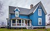 | June 19, 1980 (#80001047) | Rivers St. 34°06′33″N 85°20′12″W / 34.109167°N 85.336667°W / 34.109167; -85.336667 (John T. Mann House) | Cave Spring | |
| 28 | Mayo's Bar Lock and Dam |  | November 16, 1989 (#89002020) | On the Coosa River, 8 mi. SW of Rome 34°12′02″N 85°15′21″W / 34.200556°N 85.255833°W / 34.200556; -85.255833 (Mayo's Bar Lock and Dam) | Rome | |
| 29 | Dr. W. T. McKinney House | Upload image | June 19, 1980 (#80001049) | Cedartown St. 34°05′59″N 85°20′19″W / 34.099722°N 85.338611°W / 34.099722; -85.338611 (Dr. W. T. McKinney House) | Cave Spring | |
| 30 | Mt. Aventine Historic District | Upload image | August 18, 1983 (#83000195) | Address Restricted | Rome | |
| 31 | Myrtle Hill Cemetery |  | September 1, 1983 (#83000196) | Bounded by S. Broad, and Myrtle Sts., Pennington, and Branham Aves. 34°15′07″N 85°10′46″W / 34.251944°N 85.179444°W / 34.251944; -85.179444 (Myrtle Hill Cemetery) | Rome | |
| 32 | Oakdene Place | 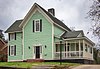 | August 4, 1983 (#83000197) | Roughly bounded by the Etowah River, Queen, and E. 6th Sts. 34°14′38″N 85°10′08″W / 34.243889°N 85.168889°W / 34.243889; -85.168889 (Oakdene Place) | Rome | |
| 33 | Old Brick Mill |  | September 9, 1993 (#93000936) | Park St. at Silver Cr. 34°11′19″N 85°10′28″W / 34.188611°N 85.174444°W / 34.188611; -85.174444 (Old Brick Mill) | Lindale | |
| 34 | Rivers Farm | Upload image | June 19, 1980 (#80001051) | Rome St. 34°07′00″N 85°20′13″W / 34.116667°N 85.336944°W / 34.116667; -85.336944 (Rivers Farm) | Cave Spring | |
| 35 | Samuel W. Robbins House |  | June 19, 1980 (#80001053) | Rome St. 34°06′30″N 85°20′10″W / 34.108333°N 85.336111°W / 34.108333; -85.336111 (Samuel W. Robbins House) | Cave Spring | |
| 36 | Rolator Park Historic District | Upload image | June 19, 1980 (#80001055) | Off U.S. 411 34°06′16″N 85°20′07″W / 34.104444°N 85.335278°W / 34.104444; -85.335278 (Rolator Park Historic District) | Cave Spring | |
| 37 | Rome Clock Tower |  | February 8, 1980 (#80001068) | Off GA 101 34°15′13″N 85°10′09″W / 34.253611°N 85.169167°W / 34.253611; -85.169167 (Rome Clock Tower) | Rome | |
| 38 | Roving House |  | June 19, 1980 (#80001057) | Rome St. 34°06′39″N 85°19′49″W / 34.110833°N 85.330278°W / 34.110833; -85.330278 (Roving House) | Cave Spring | |
| 39 | Sardis Presbyterian Church and Cemetery |  | January 12, 2005 (#04001468) | 7104 GA 20 NW 34°15′55″N 85°22′41″W / 34.265278°N 85.378056°W / 34.265278; -85.378056 (Sardis Presbyterian Church and Cemetery) | Coosa | |
| 40 | Simmons House |  | June 19, 1980 (#80001059) | Cedartown St. 34°05′57″N 85°19′59″W / 34.099167°N 85.333056°W / 34.099167; -85.333056 (Simmons House) | Cave Spring | |
| 41 | William S. Simmons Plantation | Upload image | June 19, 1980 (#80001061) | Alabama St. 34°06′03″N 85°20′41″W / 34.100833°N 85.344722°W / 34.100833; -85.344722 (William S. Simmons Plantation) | Cave Spring | |
| 42 | South Broad Street Historic District | Upload image | August 18, 1983 (#83004182) | S. Broad St. and Etowah Terrace 34°14′57″N 85°10′40″W / 34.249167°N 85.177778°W / 34.249167; -85.177778 (South Broad Street Historic District) | Rome | |
| 43 | Sullivan-Hillyer House |  | October 21, 2002 (#02001215) | 309 E. Second Ave. 34°15′00″N 85°10′17″W / 34.25°N 85.171389°W / 34.25; -85.171389 (Sullivan-Hillyer House) | Rome | |
| 44 | Thankful Baptist Church |  | September 5, 1985 (#85001973) | 935 Spiderwebb Dr. 34°15′28″N 85°09′36″W / 34.257778°N 85.16°W / 34.257778; -85.16 (Thankful Baptist Church) | Rome | |
| 45 | U.S. Post Office and Courthouse |  | May 6, 1975 (#75000592) | W. 4th Ave. and E. 1st St. 34°15′14″N 85°10′15″W / 34.253889°N 85.170833°W / 34.253889; -85.170833 (U.S. Post Office and Courthouse) | Rome | |
| 46 | Upper Avenue A Historic District | Upload image | September 1, 1983 (#83000198) | Roughly bounded by Oostanaula River, Turner-McCall Blvd., Avenue B and W. 11th St. 34°15′45″N 85°10′27″W / 34.2625°N 85.174167°W / 34.2625; -85.174167 (Upper Avenue A Historic District) | Rome | |
| 47 | George T. Watts House |  | June 19, 1980 (#80001063) | Love St. 34°06′22″N 85°20′24″W / 34.106111°N 85.34°W / 34.106111; -85.34 (George T. Watts House) | Cave Spring | |
| 48 | Wharton-Trout House | 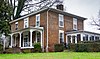 | June 19, 1980 (#80001065) | Rome St. 34°06′53″N 85°19′44″W / 34.114722°N 85.328889°W / 34.114722; -85.328889 (Wharton-Trout House) | Cave Spring |
References
- ^ National Park Service, United States Department of the Interior, "National Register of Historic Places: Weekly List Actions", retrieved August 30, 2024.
- ^ Numbers represent an alphabetical ordering by significant words. Various colorings, defined here, differentiate National Historic Landmarks and historic districts from other NRHP buildings, structures, sites or objects.
- ^ The eight-digit number below each date is the number assigned to each location in the National Register Information System database, which can be viewed by clicking the number.
Wikimedia Commons has media related to National Register of Historic Places in Floyd County, Georgia.
| |
|---|---|
| Topics | |
| Lists by state |
|
| Lists by insular areas | |
| Lists by associated state | |
| Other areas | |
| Related | |
| |


