National Register of Historic Places listings in Talbot County, Georgia
This is a list of properties and districts in Talbot County, Georgia that are listed on the National Register of Historic Places (NRHP).
Map all coordinates using OpenStreetMap
Download coordinates as:
- KML
- GPX (all coordinates)
- GPX (primary coordinates)
- GPX (secondary coordinates)
This National Park Service list is complete through NPS recent listings posted August 30, 2024.[1]
- v
- t
- e
Properties on the National Register of Historic Places in Georgia by county
- Appling
- Atkinson
- Bacon
- Baker
- Baldwin
- Banks
- Barrow
- Bartow
- Ben Hill
- Berrien
- Bibb
- Bleckley
- Brantley
- Brooks
- Bryan
- Bulloch
- Burke
- Butts
- Calhoun
- Camden
- Candler
- Carroll
- Catoosa
- Charlton
- Chatham
- Chattahoochee
- Chattooga
- Cherokee
- Clarke
- Clay
- Clayton
- Clinch
- Cobb
- Coffee
- Colquitt
- Columbia
- Cook
- Coweta
- Crawford
- Crisp
- Dade
- Dawson
- Decatur
- DeKalb
- Dodge
- Dooly
- Dougherty
- Douglas
- Early
- Echols
- Effingham
- Elbert
- Emanuel
- Evans
- Fannin
- Fayette
- Floyd
- Forsyth
- Franklin
- Fulton
- Gilmer
- Glascock
- Glynn
- Gordon
- Grady
- Greene
- Gwinnett
- Habersham
- Hall
- Hancock
- Haralson
- Harris
- Hart
- Heard
- Henry
- Houston
- Irwin
- Jackson
- Jasper
- Jeff Davis
- Jefferson
- Jenkins
- Johnson
- Jones
- Lamar
- Lanier
- Laurens
- Lee
- Liberty
- Lincoln
- Long
- Lowndes
- Lumpkin
- Macon
- Madison
- Marion
- McDuffie
- McIntosh
- Meriwether
- Miller
- Mitchell
- Monroe
- Montgomery
- Morgan
- Murray
- Muscogee
- Newton
- Oconee
- Oglethorpe
- Paulding
- Peach
- Pickens
- Pierce
- Pike
- Polk
- Pulaski
- Putnam
- Quitman
- Rabun
- Randolph
- Richmond
- Rockdale
- Schley
- Screven
- Seminole
- Spalding
- Stephens
- Stewart
- Sumter
- Talbot
- Taliaferro
- Tattnall
- Taylor
- Telfair
- Terrell
- Thomas
- Tift
- Toombs
- Towns
- Treutlen
- Troup
- Turner
- Twiggs
- Union
- Upson
- Walker
- Walton
- Ware
- Warren
- Washington
- Wayne
- Webster
- Wheeler
- White
- Whitfield
- Wilcox
- Wilkes
- Wilkinson
- Worth

Current listings
| [2] | Name on the Register | Image | Date listed[3] | Location | City or town | Description |
|---|---|---|---|---|---|---|
| 1 | Frederick A. Bailey House | Upload image | September 4, 1980 (#80001238) | U.S. 80 32°39′26″N 84°32′06″W / 32.657222°N 84.535°W / 32.657222; -84.535 (Frederick A. Bailey House) | Talbotton | Early interpretation of Greek Revival style, built in 1837. |
| 2 | Newton P. Carreker House |  | August 26, 1980 (#80001239) | 344 Jackson St. 32°40′46″N 84°32′21″W / 32.679444°N 84.539167°W / 32.679444; -84.539167 (Newton P. Carreker House) | Talbotton | |
| 3 | The Elms |  | September 4, 2004 (#04000930) | GA 36 at 47 Rising Sun Rd., 3 mi. east of Woodland. 32°47′23″N 84°30′24″W / 32.789722°N 84.506667°W / 32.789722; -84.506667 (The Elms) | Woodland | Circa 1838 |
| 4 | LeVert Historic District | 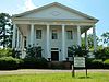 | January 11, 1976 (#76000649) | Roughly bounded by Washington Ave., railroad tracks, Madison and Smith Sts. 32°40′28″N 84°32′19″W / 32.674444°N 84.538611°W / 32.674444; -84.538611 (LeVert Historic District) | Talbotton | |
| 5 | Lockhart-Cosby Plantation |  | October 14, 1994 (#94001215) | GA 208 7 mi. E of Talbotton 32°38′38″N 84°22′48″W / 32.643889°N 84.38°W / 32.643889; -84.38 (Lockhart-Cosby Plantation) | Talbot | |
| 6 | John Frank Mathews Plantation | 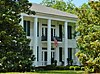 | December 4, 1986 (#86003456) | US 80 at George Smith Rd. 32°42′37″N 84°21′36″W / 32.710278°N 84.36°W / 32.710278; -84.36 (John Frank Mathews Plantation) | Prattsburg | |
| 7 | David Shelton House | 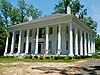 | September 17, 1980 (#80001240) | George W. Towns Ave. 32°41′10″N 84°32′04″W / 32.686111°N 84.534444°W / 32.686111; -84.534444 (David Shelton House) | Talbotton | |
| 8 | Martin and Lucretia Stamper House |  | September 10, 2007 (#07000939) | 3224 Flint Hill Hwy (GA 85E) 32°48′21″N 84°39′14″W / 32.805833°N 84.653889°W / 32.805833; -84.653889 (Martin and Lucretia Stamper House) | Shiloh | Greek Revival Plantation home built in 1833. Also known as "Merrywood". |
| 9 | Talbot County Courthouse |  | September 18, 1980 (#80001241) | Courthouse Sq. 32°40′37″N 84°32′27″W / 32.676944°N 84.540833°W / 32.676944; -84.540833 (Talbot County Courthouse) | Talbotton | |
| 10 | George W. B. Towns House |  | May 7, 1973 (#73000644) | GA 208 32°40′43″N 84°32′45″W / 32.678611°N 84.545833°W / 32.678611; -84.545833 (George W. B. Towns House) | Talbotton | |
| 11 | Weeks-Kimbrough House | 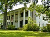 | December 27, 1979 (#79000747) | Washington Ave. 32°40′10″N 84°32′05″W / 32.669444°N 84.534722°W / 32.669444; -84.534722 (Weeks-Kimbrough House) | Talbotton | |
| 12 | Zion Episcopal Church |  | May 8, 1974 (#74000702) | S of Talbotton on U.S. 80 32°40′28″N 84°32′23″W / 32.674444°N 84.539722°W / 32.674444; -84.539722 (Zion Episcopal Church) | Talbotton |
References
- ^ National Park Service, United States Department of the Interior, "National Register of Historic Places: Weekly List Actions", retrieved August 30, 2024.
- ^ Numbers represent an alphabetical ordering by significant words. Various colorings, defined here, differentiate National Historic Landmarks and historic districts from other NRHP buildings, structures, sites or objects.
- ^ The eight-digit number below each date is the number assigned to each location in the National Register Information System database, which can be viewed by clicking the number.
Wikimedia Commons has media related to National Register of Historic Places in Talbot County, Georgia.
| |
|---|---|
| Topics | |
| Lists by state |
|
| Lists by insular areas | |
| Lists by associated state | |
| Other areas | |
| Related | |
| |


