List of listed buildings in Kirkmabreck, Dumfries and Galloway
Wikimedia Commons has media related to Kirkmabreck.
This is a list of listed buildings in the parish of Kirkmabreck, in Dumfries and Galloway, Scotland.
Map all coordinates using OpenStreetMap
Download coordinates as:
- KML
- GPX (all coordinates)
- GPX (primary coordinates)
- GPX (secondary coordinates)
List
| Name | Location | Date Listed | Grid Ref. [note 1] | Geo-coordinates | Notes | LB Number [note 2] | Image |
|---|---|---|---|---|---|---|---|
| Creetown, 63-65 And 67-69 St John Street | 54°54′00″N 4°22′45″W / 54.89992°N 4.379072°W / 54.89992; -4.379072 (Creetown, 63-65 And 67-69 St John Street) | Category C(S) | 13129 |  Upload Photo | |||
| Creetown, 26 St John Street | 54°54′02″N 4°22′46″W / 54.900418°N 4.379367°W / 54.900418; -4.379367 (Creetown, 26 St John Street) | Category C(S) | 13132 | Upload Photo | |||
| Kirkdale Bridge | 54°51′02″N 4°18′40″W / 54.850619°N 4.310987°W / 54.850619; -4.310987 (Kirkdale Bridge) | Category A | 13137 |  Upload another image | |||
| Kirkdale House And Sundial | 54°51′08″N 4°18′54″W / 54.852285°N 4.31507°W / 54.852285; -4.31507 (Kirkdale House And Sundial) | Category A | 13138 |  Upload another image | |||
| Barholm Farm | 54°51′00″N 4°18′22″W / 54.84993°N 4.306102°W / 54.84993; -4.306102 (Barholm Farm) | Category B | 10094 | Upload Photo | |||
| Creetown, High Street North, Kilbucho | 54°54′04″N 4°22′35″W / 54.901221°N 4.376466°W / 54.901221; -4.376466 (Creetown, High Street North, Kilbucho) | Category B | 10147 | Upload Photo | |||
| Creetown, Hill Of Burns, Gatepiers And Stable Courtyard | 54°53′58″N 4°22′35″W / 54.89954°N 4.376445°W / 54.89954; -4.376445 (Creetown, Hill Of Burns, Gatepiers And Stable Courtyard) | Category B | 10149 | Upload Photo | |||
| Creetown, Kirk Brae, Kirkmabreck Parish Church And Graveyard | 54°53′52″N 4°22′41″W / 54.89791°N 4.377987°W / 54.89791; -4.377987 (Creetown, Kirk Brae, Kirkmabreck Parish Church And Graveyard) | Category B | 10151 |  Upload another image | |||
| Kirkdale Mausoleum And Kirkdale Kirk And Graveyard Walls | 54°51′33″N 4°19′10″W / 54.859095°N 4.319496°W / 54.859095; -4.319496 (Kirkdale Mausoleum And Kirkdale Kirk And Graveyard Walls) | Category A | 13139 |  Upload another image | |||
| Kirkdale Steadings And Slaughterhouse | 54°51′18″N 4°19′05″W / 54.855076°N 4.318159°W / 54.855076; -4.318159 (Kirkdale Steadings And Slaughterhouse) | Category A | 13140 | Upload Photo | |||
| Cassencaire House With Gatepiers And Walled Garden | 54°53′25″N 4°22′39″W / 54.890191°N 4.377422°W / 54.890191; -4.377422 (Cassencaire House With Gatepiers And Walled Garden) | Category B | 10106 | Upload Photo | |||
| Creetown, 3 St John Street With Railings | 54°54′07″N 4°22′44″W / 54.902055°N 4.378871°W / 54.902055; -4.378871 (Creetown, 3 St John Street With Railings) | Category C(S) | 10153 | Upload Photo | |||
| Glen Farmhouse, With Stable Block | 54°53′42″N 4°16′02″W / 54.895068°N 4.267166°W / 54.895068; -4.267166 (Glen Farmhouse, With Stable Block) | Category B | 13136 | Upload Photo | |||
| Kirkmabreck Kirk | 54°52′50″N 4°21′05″W / 54.880496°N 4.35133°W / 54.880496; -4.35133 (Kirkmabreck Kirk) | Category B | 13142 |  Upload another image | |||
| Creetown, Barholm Street, Bayview With Boundary Wall, Gate And Railings | 54°54′07″N 4°22′48″W / 54.901872°N 4.379921°W / 54.901872; -4.379921 (Creetown, Barholm Street, Bayview With Boundary Wall, Gate And Railings) | Category B | 10145 | Upload Photo | |||
| Creetown,13 St John Street | 54°54′06″N 4°22′44″W / 54.901668°N 4.378863°W / 54.901668; -4.378863 (Creetown,13 St John Street) | Category C(S) | 13124 | Upload Photo | |||
| Creetown, Station Yard, Station | 54°54′39″N 4°22′45″W / 54.910858°N 4.379172°W / 54.910858; -4.379172 (Creetown, Station Yard, Station) | Category B | 13134 | Upload Photo | |||
| Barholm Castle | 54°50′58″N 4°18′20″W / 54.849509°N 4.305549°W / 54.849509; -4.305549 (Barholm Castle) | Category A | 10093 | 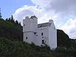 Upload another image | |||
| Creetown, 2, 4 St John Street, Ellangowan Hotel | 54°54′04″N 4°22′46″W / 54.901165°N 4.379333°W / 54.901165; -4.379333 (Creetown, 2, 4 St John Street, Ellangowan Hotel) | Category B | 13131 | Upload Photo | |||
| Creetown, South Barholm Lodge | 54°54′07″N 4°22′54″W / 54.902028°N 4.381599°W / 54.902028; -4.381599 (Creetown, South Barholm Lodge) | Category B | 13133 | Upload Photo | |||
| Carsluith Castle And Adjoining Steadings | 54°51′34″N 4°20′48″W / 54.859434°N 4.346769°W / 54.859434; -4.346769 (Carsluith Castle And Adjoining Steadings) | Category A | 10104 |  Upload another image | |||
| Creetown, Barholm Mains, Wickham Place (Former Stables) | 54°54′18″N 4°23′12″W / 54.90512°N 4.386649°W / 54.90512; -4.386649 (Creetown, Barholm Mains, Wickham Place (Former Stables)) | Category B | 10108 | Upload Photo | |||
| Creetown, 15 St John Street | 54°54′06″N 4°22′44″W / 54.90156°N 4.378857°W / 54.90156; -4.378857 (Creetown, 15 St John Street) | Category B | 13125 | Upload Photo | |||
| Creetown, 19 St John Street | 54°54′05″N 4°22′44″W / 54.901407°N 4.378879°W / 54.901407; -4.378879 (Creetown, 19 St John Street) | Category C(S) | 13127 | Upload Photo | |||
| Carsluith, Corn Mill And Round-Ended Barn | 54°51′56″N 4°21′12″W / 54.865536°N 4.353326°W / 54.865536; -4.353326 (Carsluith, Corn Mill And Round-Ended Barn) | Category B | 10105 | Upload Photo | |||
| Creetown, Crispin Street, St Crispins | 54°53′56″N 4°22′42″W / 54.898979°N 4.378471°W / 54.898979; -4.378471 (Creetown, Crispin Street, St Crispins) | Category B | 10146 | Upload Photo | |||
| Creetown, Hill Of Burns Hotel And Sundial | 54°53′59″N 4°22′40″W / 54.899629°N 4.37787°W / 54.899629; -4.37787 (Creetown, Hill Of Burns Hotel And Sundial) | Category B | 10148 | Upload Photo | |||
| Glebe House | 54°52′49″N 4°22′26″W / 54.880228°N 4.373889°W / 54.880228; -4.373889 (Glebe House) | Category B | 13135 | Upload Photo | |||
| Creetown, Hill Street, St Josephs Roman Catholic Church | 54°54′05″N 4°22′40″W / 54.901473°N 4.377822°W / 54.901473; -4.377822 (Creetown, Hill Street, St Josephs Roman Catholic Church) | Category B | 10150 | Upload Photo | |||
| Creetown Moneypool Bridge | 54°54′11″N 4°22′47″W / 54.903009°N 4.379691°W / 54.903009; -4.379691 (Creetown Moneypool Bridge) | Category C(S) | 10152 | Upload Photo | |||
| Creetown ,5 St John Street | 54°54′07″N 4°22′44″W / 54.90201°N 4.378868°W / 54.90201; -4.378868 (Creetown ,5 St John Street) | Category C(S) | 10154 | Upload Photo | |||
| Creetown, 7-9 St John Street | 54°54′07″N 4°22′44″W / 54.901829°N 4.378904°W / 54.901829; -4.378904 (Creetown, 7-9 St John Street) | Category C(S) | 10155 | Upload Photo | |||
| Creetown, 17 St John Street | 54°54′05″N 4°22′44″W / 54.90147°N 4.378883°W / 54.90147; -4.378883 (Creetown, 17 St John Street) | Category B | 13126 | Upload Photo | |||
| Creetown,59-61 St John Street, Cherry Trees And Stables | 54°54′00″N 4°22′44″W / 54.900092°N 4.379004°W / 54.900092; -4.379004 (Creetown,59-61 St John Street, Cherry Trees And Stables) | Category C(S) | 13128 | Upload Photo | |||
| Creetown, 75 St John Street | 54°53′59″N 4°22′45″W / 54.899695°N 4.37909°W / 54.899695; -4.37909 (Creetown, 75 St John Street) | Category C(S) | 13130 | Upload Photo | |||
| Kirkdale Ice House | 54°50′59″N 4°18′44″W / 54.849645°N 4.312099°W / 54.849645; -4.312099 (Kirkdale Ice House) | Category C(S) | 13141 | Upload Photo | |||
| Carsluith, Bridge Cottage | 54°51′53″N 4°21′20″W / 54.864658°N 4.355504°W / 54.864658; -4.355504 (Carsluith, Bridge Cottage) | Category C(S) | 10095 | Upload Photo | |||
| Creetown, Adamson Square, Clocktower | 54°54′05″N 4°22′45″W / 54.901509°N 4.379182°W / 54.901509; -4.379182 (Creetown, Adamson Square, Clocktower) | Category C(S) | 10107 | Upload Photo | |||
| 11 Creetown, St John Street | 54°54′06″N 4°22′44″W / 54.901767°N 4.378869°W / 54.901767; -4.378869 (11 Creetown, St John Street) | Category B | 10156 | Upload Photo |
Key
The scheme for classifying buildings in Scotland is:
- Category A: "buildings of national or international importance, either architectural or historic; or fine, little-altered examples of some particular period, style or building type."[1]
- Category B: "buildings of regional or more than local importance; or major examples of some particular period, style or building type, which may have been altered."[1]
- Category C: "buildings of local importance; lesser examples of any period, style, or building type, as originally constructed or moderately altered; and simple traditional buildings which group well with other listed buildings."[1]
In March 2016 there were 47,288 listed buildings in Scotland. Of these, 8% were Category A, and 50% were Category B, with the remaining 42% being Category C.[2]
Notes
- ^ Sometimes known as OSGB36, the grid reference (where provided) is based on the British national grid reference system used by the Ordnance Survey.
• "Guide to National Grid". Ordnance Survey. Retrieved 12 December 2007.
• "Get-a-map". Ordnance Survey. Retrieved 17 December 2007. - ^ Historic Environment Scotland assign a unique alphanumeric identifier to each designated site in Scotland, for listed buildings this always begins with "LB", for example "LB12345".
References
- All entries, addresses and coordinates are based on data from Historic Scotland. This data falls under the Open Government Licence
- ^ a b c "What is Listing?". Historic Environment Scotland. Retrieved 29 May 2018.
- ^ Scotland's Historic Environment Audit 2016 (PDF). Historic Environment Scotland and the Built Environment Forum Scotland. pp. 15–16. Retrieved 29 May 2018.
- v
- t
- e
- Annan
- Applegarth
- Caerlaverock
- Canonbie
- Closeburn
- Cummertrees
- Dalton
- Dornock
- Dryfesdale
- Dumfries
- Dunscore
- Durisdeer
- Eskdalemuir
- Ewes
- Glencairn
- Gretna
- Half Morton
- Hoddom
- Holywood
- Hutton and Corrie
- Johnstone
- Keir
- Kirkconnel
- Kirkmahoe
- Kirkmichael
- Kirkpatrick-Fleming
- Kirkpatrick-Juxta
- Langholm
- Lochmaben
- Lockerbie
- Middlebie
- Moffat
- Morton
- Mouswald
- Penpont
- Ruthwell
- Sanquhar
- St Mungo
- Tinwald
- Torthorwald
- Tundergarth
- Tynron
- Wamphray
- Westerkirk
- Anwoth
- Balmaclellan
- Balmaghie
- Borgue
- Buittle
- Carsphairn
- Castle Douglas
- Colvend and Southwick
- Crossmichael
- Dalbeattie
- Dalry
- Gatehouse of Fleet
- Girthon
- Kells
- Kelton
- Kirkbean
- Kirkcudbright
- Kirkgunzeon
- Kirkmabreck
- Kirkpatrick Durham
- Kirkpatrick Irongray
- Lochrutton
- Minnigaff
- New Abbey
- New Galloway
- Newton Stewart
- Parton
- Rerrick
- Terregles
- Tongland
- Troqueer
- Twynholm
- Urr


