List of listed buildings in Durisdeer, Dumfries and Galloway
This is a list of listed buildings in the parish of Durisdeer in Dumfries and Galloway, Scotland.
Map all coordinates using OpenStreetMap
Download coordinates as:
- KML
- GPX (all coordinates)
- GPX (primary coordinates)
- GPX (secondary coordinates)
List
| Name | Location | Date Listed | Grid Ref. [note 1] | Geo-coordinates | Notes | LB Number [note 2] | Image |
|---|---|---|---|---|---|---|---|
| Carronbridge Mill Office And Former Cartshed | 55°15′37″N 3°46′59″W / 55.260414°N 3.782925°W / 55.260414; -3.782925 (Carronbridge Mill Office And Former Cartshed) | Category B | 3867 |  Upload Photo | |||
| Coshogle Farmhouse And Steading | 55°19′33″N 3°47′47″W / 55.32596°N 3.796302°W / 55.32596; -3.796302 (Coshogle Farmhouse And Steading) | Category B | 3880 | Upload Photo | |||
| Coshogle Cottage | 55°19′43″N 3°47′33″W / 55.328613°N 3.792528°W / 55.328613; -3.792528 (Coshogle Cottage) | Category C(S) | 3881 | Upload Photo | |||
| Crairiepark Farmhouse And Steading | 55°19′07″N 3°48′57″W / 55.318633°N 3.815907°W / 55.318633; -3.815907 (Crairiepark Farmhouse And Steading) | Category B | 3883 | Upload Photo | |||
| Drumlanrig Creel Bridge | 55°17′08″N 3°48′12″W / 55.285647°N 3.803346°W / 55.285647; -3.803346 (Drumlanrig Creel Bridge) | Category B | 3889 | Upload Photo | |||
| Durisdeer Village Hope Cottage | 55°18′54″N 3°44′41″W / 55.314987°N 3.744795°W / 55.314987; -3.744795 (Durisdeer Village Hope Cottage) | Category C(S) | 3859 | Upload Photo | |||
| Durisdeer Village Rose Cottage | 55°18′55″N 3°44′40″W / 55.315216°N 3.744522°W / 55.315216; -3.744522 (Durisdeer Village Rose Cottage) | Category C(S) | 3870 | Upload Photo | |||
| Enterkin Viaduct | 55°19′10″N 3°48′05″W / 55.31954°N 3.801402°W / 55.31954; -3.801402 (Enterkin Viaduct) | Category B | 3872 | Upload Photo | |||
| Crairiehill Farmhouse And Steading | 55°18′47″N 3°48′23″W / 55.312949°N 3.806476°W / 55.312949; -3.806476 (Crairiehill Farmhouse And Steading) | Category B | 3882 | Upload Photo | |||
| Drumlanrig Bridge Cottage | 55°16′49″N 3°47′49″W / 55.280195°N 3.797037°W / 55.280195; -3.797037 (Drumlanrig Bridge Cottage) | Category B | 3888 |  Upload another image | |||
| Drumlanrig Mains Offices, Sawmill And Workshops | 55°16′54″N 3°48′31″W / 55.281795°N 3.80854°W / 55.281795; -3.80854 (Drumlanrig Mains Offices, Sawmill And Workshops) | Category B | 3893 | Upload Photo | |||
| Sweetbit Farmhouse And Steading | 55°18′22″N 3°48′15″W / 55.306046°N 3.804083°W / 55.306046; -3.804083 (Sweetbit Farmhouse And Steading) | Category B | 3860 | Upload Photo | |||
| 18-22 (Numbers Inclusive) Carronbridge Village | 55°15′52″N 3°46′50″W / 55.264383°N 3.780694°W / 55.264383; -3.780694 (18-22 (Numbers Inclusive) Carronbridge Village) | Category B | 3864 | Upload Photo | |||
| Carronbridge Village Miss Findlater (Formerly Smithy Cottage) Former Smithy And Smithy Cottage | 55°15′53″N 3°46′49″W / 55.264657°N 3.780408°W / 55.264657; -3.780408 (Carronbridge Village Miss Findlater (Formerly Smithy Cottage) Former Smithy And Smithy Cottage) | Category C(S) | 3865 | Upload Photo | |||
| Carronbridge Village Moss Side House And Gatepiers | 55°16′01″N 3°46′56″W / 55.266996°N 3.782118°W / 55.266996; -3.782118 (Carronbridge Village Moss Side House And Gatepiers) | Category B | 3868 | Upload Photo | |||
| Gateslack Farmhouse | 55°18′12″N 3°44′52″W / 55.30326°N 3.747872°W / 55.30326; -3.747872 (Gateslack Farmhouse) | Category B | 3873 | Upload Photo | |||
| Holestane Farmhouse, Steading, Dairy And Outbuildings | 55°16′49″N 3°46′36″W / 55.280259°N 3.776697°W / 55.280259; -3.776697 (Holestane Farmhouse, Steading, Dairy And Outbuildings) | Category B | 3876 | Upload Photo | |||
| Priestcrown Wood Railway Embankment | 55°19′27″N 3°48′34″W / 55.324094°N 3.809458°W / 55.324094; -3.809458 (Priestcrown Wood Railway Embankment) | Category B | 3879 | Upload Photo | |||
| Dalveen Farm Martyr's Monument | 55°20′40″N 3°45′40″W / 55.344555°N 3.761061°W / 55.344555; -3.761061 (Dalveen Farm Martyr's Monument) | Category B | 3885 | Upload Photo | |||
| Ballagan North Range Of Steading (Former Stable, Cartshed And Barn) | 55°17′33″N 3°50′21″W / 55.29249°N 3.839219°W / 55.29249; -3.839219 (Ballagan North Range Of Steading (Former Stable, Cartshed And Barn)) | Category B | 3896 | Upload Photo | |||
| Drumlanrig Summer House North Of Duchess Well | 55°16′23″N 3°48′48″W / 55.273161°N 3.813201°W / 55.273161; -3.813201 (Drumlanrig Summer House North Of Duchess Well) | Category B | 3854 | Upload Photo | |||
| Durisdeer Village Durisdeer Parish Church, Queensberry Mausoleum, Former School/Vestry And Churchyard | 55°18′56″N 3°44′39″W / 55.315536°N 3.744157°W / 55.315536; -3.744157 (Durisdeer Village Durisdeer Parish Church, Queensberry Mausoleum, Former School/Vestry And Churchyard) | Category A | 3856 | Upload Photo | |||
| Durisdeer Village Castlehill Cottage | 55°18′57″N 3°45′10″W / 55.315772°N 3.752725°W / 55.315772; -3.752725 (Durisdeer Village Castlehill Cottage) | Category C(S) | 3857 | Upload Photo | |||
| Carronbridge Village Carronfoot House | 55°15′47″N 3°47′06″W / 55.262972°N 3.784975°W / 55.262972; -3.784975 (Carronbridge Village Carronfoot House) | Category B | 3866 | Upload Photo | |||
| Kirkbride Churchyard | 55°19′54″N 3°48′25″W / 55.331583°N 3.80682°W / 55.331583; -3.80682 (Kirkbride Churchyard) | Category B | 3877 | Upload Photo | |||
| Dalveen Farm House Steading And Barn | 55°20′37″N 3°45′39″W / 55.343641°N 3.760863°W / 55.343641; -3.760863 (Dalveen Farm House Steading And Barn) | Category B | 3884 | Upload Photo | |||
| Drumlanrig Bridge (Drumlanrig Castle East Approach Over River Nith | 55°16′47″N 3°47′49″W / 55.279692°N 3.797014°W / 55.279692; -3.797014 (Drumlanrig Bridge (Drumlanrig Castle East Approach Over River Nith) | Category B | 3887 | 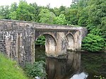 Upload another image | |||
| Drumlanrig Laundry Cottages | 55°16′36″N 3°48′38″W / 55.276749°N 3.810641°W / 55.276749; -3.810641 (Drumlanrig Laundry Cottages) | Category B | 3892 | Upload Photo | |||
| Alton Farmhouse And Steading | 55°17′49″N 3°48′22″W / 55.296967°N 3.806049°W / 55.296967; -3.806049 (Alton Farmhouse And Steading) | Category B | 3894 | Upload Photo | |||
| Drumlanrig St Geoffrey's Bridge | 55°16′17″N 3°49′01″W / 55.271399°N 3.816914°W / 55.271399; -3.816914 (Drumlanrig St Geoffrey's Bridge) | Category C(S) | 3853 |  Upload another image | |||
| Carronbank Cottage And Outbuildings | 55°17′33″N 3°45′42″W / 55.292493°N 3.761668°W / 55.292493; -3.761668 (Carronbank Cottage And Outbuildings) | Category B | 3862 | Upload Photo | |||
| Glenarlie Bridge | 55°19′51″N 3°50′15″W / 55.330928°N 3.837532°W / 55.330928; -3.837532 (Glenarlie Bridge) | Category B | 3874 | Upload Photo | |||
| Drumlanrig Gardener's Cottage (At Flower Garden) | 55°16′23″N 3°48′23″W / 55.27312°N 3.806273°W / 55.27312; -3.806273 (Drumlanrig Gardener's Cottage (At Flower Garden)) | Category C(S) | 3890 | Upload Photo | |||
| Drumlanrig Glass House In Flower Garden | 55°16′23″N 3°48′23″W / 55.272967°N 3.806282°W / 55.272967; -3.806282 (Drumlanrig Glass House In Flower Garden) | Category B | 3891 |  Upload another image | |||
| Ardoch Farmhouse And Steading | 55°19′45″N 3°49′54″W / 55.32919°N 3.831776°W / 55.32919; -3.831776 (Ardoch Farmhouse And Steading) | Category B | 3895 | Upload Photo | |||
| Drumlanrig Cottages At Drumlanrig Mains | 55°16′52″N 3°48′34″W / 55.281182°N 3.809316°W / 55.281182; -3.809316 (Drumlanrig Cottages At Drumlanrig Mains) | Category C(S) | 3852 | Upload Photo | |||
| Durisdeer Village Glenview Mr Henson | 55°18′54″N 3°44′38″W / 55.314963°N 3.743959°W / 55.314963; -3.743959 (Durisdeer Village Glenview Mr Henson) | Category B | 3858 | Upload Photo | |||
| Carron Water And A702 Railway Viaduct | 55°17′29″N 3°45′52″W / 55.291501°N 3.764396°W / 55.291501; -3.764396 (Carron Water And A702 Railway Viaduct) | Category B | 3861 | Upload Photo | |||
| Carronbridge Village Carron Bridge (A76 Over Carron Water) | 55°15′51″N 3°46′49″W / 55.264246°N 3.780232°W / 55.264246; -3.780232 (Carronbridge Village Carron Bridge (A76 Over Carron Water)) | Category B | 3863 | Upload Photo | |||
| Drumlanrig Summerhouse To South West Of Mansion | 55°16′23″N 3°48′48″W / 55.273161°N 3.813201°W / 55.273161; -3.813201 (Drumlanrig Summerhouse To South West Of Mansion) | Category B | 3855 |  Upload another image | |||
| Durisdeer Mill Village Old Foot Bridge Over Carron Water | 55°19′07″N 3°45′42″W / 55.318744°N 3.761697°W / 55.318744; -3.761697 (Durisdeer Mill Village Old Foot Bridge Over Carron Water) | Category B | 3871 | Upload Photo | |||
| Hapland Farmhouse And Steading | 55°18′56″N 3°47′30″W / 55.315648°N 3.791612°W / 55.315648; -3.791612 (Hapland Farmhouse And Steading) | Category B | 3875 | Upload Photo | |||
| Chapel Farmhouse And Steading | 55°19′49″N 3°45′58″W / 55.330356°N 3.76598°W / 55.330356; -3.76598 (Chapel Farmhouse And Steading) | Category B | 3869 | Upload Photo | |||
| Drumlanrig Castle, Outbuildings and Pavilion Blocks Piers, Balustrades and Quadrant Walls and Garden Urns | 55°16′25″N 3°48′31″W / 55.273651°N 3.808705°W / 55.273651; -3.808705 (Drumlanrig Castle, Outbuildings and Pavilion Blocks Piers, Balustrades and Quadrant Walls and Garden Urns) | Category A | 3886 |  Upload another image |
Key
The scheme for classifying buildings in Scotland is:
- Category A: "buildings of national or international importance, either architectural or historic; or fine, little-altered examples of some particular period, style or building type."[1]
- Category B: "buildings of regional or more than local importance; or major examples of some particular period, style or building type, which may have been altered."[1]
- Category C: "buildings of local importance; lesser examples of any period, style, or building type, as originally constructed or moderately altered; and simple traditional buildings which group well with other listed buildings."[1]
In March 2016 there were 47,288 listed buildings in Scotland. Of these, 8% were Category A, and 50% were Category B, with the remaining 42% being Category C.[2]
Notes
- ^ Sometimes known as OSGB36, the grid reference (where provided) is based on the British national grid reference system used by the Ordnance Survey.
• "Guide to National Grid". Ordnance Survey. Retrieved 12 December 2007.
• "Get-a-map". Ordnance Survey. Retrieved 17 December 2007. - ^ Historic Environment Scotland assign a unique alphanumeric identifier to each designated site in Scotland, for listed buildings this always begins with "LB", for example "LB12345".
References
- All entries, addresses and coordinates are based on data from Historic Scotland. This data falls under the Open Government Licence
- ^ a b c "What is Listing?". Historic Environment Scotland. Retrieved 29 May 2018.
- ^ Scotland's Historic Environment Audit 2016 (PDF). Historic Environment Scotland and the Built Environment Forum Scotland. pp. 15–16. Retrieved 29 May 2018.
- v
- t
- e
- Annan
- Applegarth
- Caerlaverock
- Canonbie
- Closeburn
- Cummertrees
- Dalton
- Dornock
- Dryfesdale
- Dumfries
- Dunscore
- Durisdeer
- Eskdalemuir
- Ewes
- Glencairn
- Gretna
- Half Morton
- Hoddom
- Holywood
- Hutton and Corrie
- Johnstone
- Keir
- Kirkconnel
- Kirkmahoe
- Kirkmichael
- Kirkpatrick-Fleming
- Kirkpatrick-Juxta
- Langholm
- Lochmaben
- Lockerbie
- Middlebie
- Moffat
- Morton
- Mouswald
- Penpont
- Ruthwell
- Sanquhar
- St Mungo
- Tinwald
- Torthorwald
- Tundergarth
- Tynron
- Wamphray
- Westerkirk
- Anwoth
- Balmaclellan
- Balmaghie
- Borgue
- Buittle
- Carsphairn
- Castle Douglas
- Colvend and Southwick
- Crossmichael
- Dalbeattie
- Dalry
- Gatehouse of Fleet
- Girthon
- Kells
- Kelton
- Kirkbean
- Kirkcudbright
- Kirkgunzeon
- Kirkmabreck
- Kirkpatrick Durham
- Kirkpatrick Irongray
- Lochrutton
- Minnigaff
- New Abbey
- New Galloway
- Newton Stewart
- Parton
- Rerrick
- Terregles
- Tongland
- Troqueer
- Twynholm
- Urr


