List of listed buildings in Girthon, Dumfries and Galloway
This is a list of listed buildings in the civil parish of Girthon, Dumfries and Galloway, Scotland.
Map all coordinates using OpenStreetMap
Download coordinates as:
- KML
- GPX (all coordinates)
- GPX (primary coordinates)
- GPX (secondary coordinates)
List
| Name | Location | Date Listed | Grid Ref. [note 1] | Geo-coordinates | Notes | LB Number [note 2] | Image |
|---|---|---|---|---|---|---|---|
| Clauchan Cottage Girthon | 54°51′26″N 4°10′25″W / 54.85732°N 4.173556°W / 54.85732; -4.173556 (Clauchan Cottage Girthon) | Category C(S) | 9861 |  Upload Photo | |||
| The Temple, (Cally Estate) | 54°51′50″N 4°10′26″W / 54.863793°N 4.173951°W / 54.863793; -4.173951 (The Temple, (Cally Estate)) | Category B | 9851 | Upload Photo | |||
| Disdow And Outbuildings | 54°53′08″N 4°09′36″W / 54.88566°N 4.159974°W / 54.88566; -4.159974 (Disdow And Outbuildings) | Category C(S) | 9856 | Upload Photo | |||
| Enrick Farmhouse | 54°52′01″N 4°09′32″W / 54.867071°N 4.158995°W / 54.867071; -4.158995 (Enrick Farmhouse) | Category B | 9857 | Upload Photo | |||
| High Lodge, (Cally Estate) | 54°52′18″N 4°09′34″W / 54.871685°N 4.159382°W / 54.871685; -4.159382 (High Lodge, (Cally Estate)) | Category B | 9860 | Upload Photo | |||
| Belvedere Lodge (Cally Estate) | 54°52′07″N 4°10′41″W / 54.868639°N 4.177921°W / 54.868639; -4.177921 (Belvedere Lodge (Cally Estate)) | Category B | 9865 | Upload Photo | |||
| Girthon Old Kirk And Churchyard | 54°51′21″N 4°10′26″W / 54.855715°N 4.173828°W / 54.855715; -4.173828 (Girthon Old Kirk And Churchyard) | Category A | 9859 | 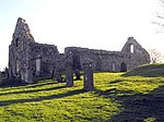 Upload another image | |||
| Cally Mains Hay Barn | 54°51′47″N 4°11′45″W / 54.862942°N 4.195768°W / 54.862942; -4.195768 (Cally Mains Hay Barn) | Category B | 9853 | Upload Photo | |||
| Dalmalin Lodge | 54°53′58″N 4°11′11″W / 54.899364°N 4.186302°W / 54.899364; -4.186302 (Dalmalin Lodge) | Category C(S) | 9863 | Upload Photo | |||
| Cally Palace Hotel, Formerly Cally House | 54°52′11″N 4°11′00″W / 54.869628°N 4.183429°W / 54.869628; -4.183429 (Cally Palace Hotel, Formerly Cally House) | Category A | 9854 | Upload Photo | |||
| Furgusson Tombstone | 55°00′45″N 4°11′08″W / 55.012625°N 4.18544°W / 55.012625; -4.18544 (Furgusson Tombstone) | Category C(S) | 9858 | Upload Photo | |||
| Kirk House (Former Manse) | 54°51′22″N 4°10′26″W / 54.856219°N 4.173808°W / 54.856219; -4.173808 (Kirk House (Former Manse)) | Category B | 9862 | Upload Photo | |||
| Cally Mains Farm Steading | 54°51′49″N 4°11′43″W / 54.863498°N 4.195331°W / 54.863498; -4.195331 (Cally Mains Farm Steading) | Category B | 9866 | Upload Photo | |||
| Cross Cottage, (Cally Estate) | 54°52′29″N 4°10′41″W / 54.874667°N 4.178075°W / 54.874667; -4.178075 (Cross Cottage, (Cally Estate)) | Category B | 9855 | Upload Photo | |||
| Walled Garden, (Calley Estate) | 54°52′12″N 4°10′35″W / 54.869917°N 4.176338°W / 54.869917; -4.176338 (Walled Garden, (Calley Estate)) | Category B | 43278 | Upload Photo | |||
| Auchencloy Monument | 55°00′46″N 4°11′06″W / 55.012658°N 4.185114°W / 55.012658; -4.185114 (Auchencloy Monument) | Category C(S) | 9864 | Upload Photo | |||
| Cally Mains Farmhouse | 54°51′46″N 4°11′50″W / 54.862837°N 4.197087°W / 54.862837; -4.197087 (Cally Mains Farmhouse) | Category B | 9852 | Upload Photo |
Key
The scheme for classifying buildings in Scotland is:
- Category A: "buildings of national or international importance, either architectural or historic; or fine, little-altered examples of some particular period, style or building type."[1]
- Category B: "buildings of regional or more than local importance; or major examples of some particular period, style or building type, which may have been altered."[1]
- Category C: "buildings of local importance; lesser examples of any period, style, or building type, as originally constructed or moderately altered; and simple traditional buildings which group well with other listed buildings."[1]
In March 2016 there were 47,288 listed buildings in Scotland. Of these, 8% were Category A, and 50% were Category B, with the remaining 42% being Category C.[2]
Notes
- ^ Sometimes known as OSGB36, the grid reference (where provided) is based on the British national grid reference system used by the Ordnance Survey.
• "Guide to National Grid". Ordnance Survey. Retrieved 12 December 2007.
• "Get-a-map". Ordnance Survey. Retrieved 17 December 2007. - ^ Historic Environment Scotland assign a unique alphanumeric identifier to each designated site in Scotland, for listed buildings this always begins with "LB", for example "LB12345".
References
- All entries, addresses and coordinates are based on data from Historic Scotland. This data falls under the Open Government Licence
- ^ a b c "What is Listing?". Historic Environment Scotland. Retrieved 29 May 2018.
- ^ Scotland's Historic Environment Audit 2016 (PDF). Historic Environment Scotland and the Built Environment Forum Scotland. pp. 15–16. Retrieved 29 May 2018.
- v
- t
- e
- Annan
- Applegarth
- Caerlaverock
- Canonbie
- Closeburn
- Cummertrees
- Dalton
- Dornock
- Dryfesdale
- Dumfries
- Dunscore
- Durisdeer
- Eskdalemuir
- Ewes
- Glencairn
- Gretna
- Half Morton
- Hoddom
- Holywood
- Hutton and Corrie
- Johnstone
- Keir
- Kirkconnel
- Kirkmahoe
- Kirkmichael
- Kirkpatrick-Fleming
- Kirkpatrick-Juxta
- Langholm
- Lochmaben
- Lockerbie
- Middlebie
- Moffat
- Morton
- Mouswald
- Penpont
- Ruthwell
- Sanquhar
- St Mungo
- Tinwald
- Torthorwald
- Tundergarth
- Tynron
- Wamphray
- Westerkirk
- Anwoth
- Balmaclellan
- Balmaghie
- Borgue
- Buittle
- Carsphairn
- Castle Douglas
- Colvend and Southwick
- Crossmichael
- Dalbeattie
- Dalry
- Gatehouse of Fleet
- Girthon
- Kells
- Kelton
- Kirkbean
- Kirkcudbright
- Kirkgunzeon
- Kirkmabreck
- Kirkpatrick Durham
- Kirkpatrick Irongray
- Lochrutton
- Minnigaff
- New Abbey
- New Galloway
- Newton Stewart
- Parton
- Rerrick
- Terregles
- Tongland
- Troqueer
- Twynholm
- Urr


