List of listed buildings in Castle Douglas, Dumfries and Galloway
This is a list of listed buildings in the Civil Parish of Castle Douglas in the historical county of Kirkcudbrightshire in Dumfries and Galloway, Scotland.
Map all coordinates using OpenStreetMap
Download coordinates as:
- KML
- GPX (all coordinates)
- GPX (primary coordinates)
- GPX (secondary coordinates)
List
| Name | Location | Date Listed | Grid Ref. [note 1] | Geo-coordinates | Notes | LB Number [note 2] | Image |
|---|---|---|---|---|---|---|---|
| 114-118 (Even Nos) Queen Street | 54°56′21″N 3°55′48″W / 54.939093°N 3.92997°W / 54.939093; -3.92997 (114-118 (Even Nos) Queen Street) | Category C(S) | 22977 |  Upload Photo | |||
| 11-15 (Odd Nos) St Andrews Street And King Street, The Douglas Arms Hotel | 54°56′21″N 3°55′55″W / 54.939285°N 3.932056°W / 54.939285; -3.932056 (11-15 (Odd Nos) St Andrews Street And King Street, The Douglas Arms Hotel) | Category C(S) | 22980 | Upload Photo | |||
| Kelton Manse Of Kelton Stables | 54°55′23″N 3°56′13″W / 54.92294°N 3.936874°W / 54.92294; -3.936874 (Kelton Manse Of Kelton Stables) | Category C(S) | 22972 | Upload Photo | |||
| Lochbank With Gatepiers And Boundary Walls | 54°55′47″N 3°56′14″W / 54.929622°N 3.937211°W / 54.929622; -3.937211 (Lochbank With Gatepiers And Boundary Walls) | Category B | 50124 | Upload Photo | |||
| 210 And 212 King Street And 32 St Andrew Street | 54°56′20″N 3°55′56″W / 54.93902°N 3.932308°W / 54.93902; -3.932308 (210 And 212 King Street And 32 St Andrew Street) | Category C(S) | 50164 | Upload Photo | |||
| Furbar | 54°55′41″N 3°56′26″W / 54.927923°N 3.940563°W / 54.927923; -3.940563 (Furbar) | Category B | 22971 | Upload Photo | |||
| 122-126 (Even Nos) Queen Street | 54°56′20″N 3°55′48″W / 54.938992°N 3.930106°W / 54.938992; -3.930106 (122-126 (Even Nos) Queen Street) | Category C(S) | 22978 | Upload Photo | |||
| 66 St Andrew Street | 54°56′15″N 3°55′45″W / 54.937525°N 3.929115°W / 54.937525; -3.929115 (66 St Andrew Street) | Category B | 49413 | Upload Photo | |||
| 193 & 195 King Street, The Merrick Hotel | 54°56′21″N 3°55′54″W / 54.93903°N 3.931716°W / 54.93903; -3.931716 (193 & 195 King Street, The Merrick Hotel) | Category C(S) | 50048 | Upload Photo | |||
| Threave Lodge And Gates | 54°55′37″N 3°56′25″W / 54.926806°N 3.94015°W / 54.926806; -3.94015 (Threave Lodge And Gates) | Category C(S) | 22984 | Upload Photo | |||
| Littlebank (Former Lodge To Lochbank), With Boundary Walls | 54°55′46″N 3°56′15″W / 54.929581°N 3.93749°W / 54.929581; -3.93749 (Littlebank (Former Lodge To Lochbank), With Boundary Walls) | Category C(S) | 50125 | Upload Photo | |||
| Abercromby Road, St John The Evangelist, Rc Church, Presbytery And Retaining Walls | 54°56′24″N 3°56′00″W / 54.94012°N 3.933235°W / 54.94012; -3.933235 (Abercromby Road, St John The Evangelist, Rc Church, Presbytery And Retaining Walls) | Category C(S) | 22970 | Upload Photo | |||
| Kirkland House And Gatepiers | 54°55′36″N 3°56′21″W / 54.92676°N 3.939134°W / 54.92676; -3.939134 (Kirkland House And Gatepiers) | Category B | 22975 | Upload Photo | |||
| Abercromby Road, Kilmichael - Outbuilding Formerly Old House Of Fuffnock | 54°56′41″N 3°56′27″W / 54.944745°N 3.94078°W / 54.944745; -3.94078 (Abercromby Road, Kilmichael - Outbuilding Formerly Old House Of Fuffnock) | Category C(S) | 22969 | Upload Photo | |||
| 131-133 (Odd Nos) King Street, Royal Bank Scotland | 54°56′25″N 3°55′49″W / 54.940195°N 3.930195°W / 54.940195; -3.930195 (131-133 (Odd Nos) King Street, Royal Bank Scotland) | Category B | 22973 | Upload Photo | |||
| New Market Street Castle Douglas Cattle Mart | 54°56′33″N 3°55′28″W / 54.942479°N 3.924496°W / 54.942479; -3.924496 (New Market Street Castle Douglas Cattle Mart) | Category A | 22976 | 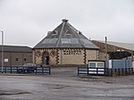 Upload another image | |||
| St Andrew Street, Town Hall And Customs House | 54°56′23″N 3°55′57″W / 54.9396°N 3.93257°W / 54.9396; -3.93257 (St Andrew Street, Town Hall And Customs House) | Category B | 22979 | Upload Photo | |||
| Marle Street And Lochside Road, Lochside Theatre Former St Andrews Parish Church (Church Of Scotland) With Retaining Walls, Railings, Piers And Lamp Standards | 54°56′13″N 3°55′51″W / 54.937048°N 3.930871°W / 54.937048; -3.930871 (Marle Street And Lochside Road, Lochside Theatre Former St Andrews Parish Church (Church Of Scotland) With Retaining Walls, Railings, Piers And Lamp Standards) | Category C(S) | 22981 | Upload Photo | |||
| St Andrew Street, The Brae | 54°56′18″N 3°55′43″W / 54.938432°N 3.928612°W / 54.938432; -3.928612 (St Andrew Street, The Brae) | Category B | 22982 | Upload Photo | |||
| St Andrew Street, The Grove | 54°56′15″N 3°55′38″W / 54.937364°N 3.927358°W / 54.937364; -3.927358 (St Andrew Street, The Grove) | Category C(S) | 22983 | Upload Photo | |||
| King Street, Castle Douglas Library With Art Gallery, Boundary Wall, Railings, Gates And Gatepiers | 54°56′32″N 3°55′38″W / 54.94212°N 3.927305°W / 54.94212; -3.927305 (King Street, Castle Douglas Library With Art Gallery, Boundary Wall, Railings, Gates And Gatepiers) | Category B | 49671 |  Upload another image | |||
| 35 King Street, Imperial Hotel | 54°56′32″N 3°55′41″W / 54.942207°N 3.928043°W / 54.942207; -3.928043 (35 King Street, Imperial Hotel) | Category B | 22974 | 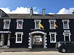 Upload another image | |||
| Whitepark Road, St Ninians Episcopal Church | 54°56′13″N 3°55′41″W / 54.936821°N 3.928175°W / 54.936821; -3.928175 (Whitepark Road, St Ninians Episcopal Church) | Category B | 22985 | Upload Photo |
Key
The scheme for classifying buildings in Scotland is:
- Category A: "buildings of national or international importance, either architectural or historic; or fine, little-altered examples of some particular period, style or building type."[1]
- Category B: "buildings of regional or more than local importance; or major examples of some particular period, style or building type, which may have been altered."[1]
- Category C: "buildings of local importance; lesser examples of any period, style, or building type, as originally constructed or moderately altered; and simple traditional buildings which group well with other listed buildings."[1]
In March 2016 there were 47,288 listed buildings in Scotland. Of these, 8% were Category A, and 50% were Category B, with the remaining 42% being Category C.[2]
Notes
- ^ Sometimes known as OSGB36, the grid reference (where provided) is based on the British national grid reference system used by the Ordnance Survey.
• "Guide to National Grid". Ordnance Survey. Retrieved 12 December 2007.
• "Get-a-map". Ordnance Survey. Retrieved 17 December 2007. - ^ Historic Environment Scotland assign a unique alphanumeric identifier to each designated site in Scotland, for listed buildings this always begins with "LB", for example "LB12345".
References
- All entries, addresses and coordinates are based on data from Historic Scotland. This data falls under the Open Government Licence
- ^ a b c "What is Listing?". Historic Environment Scotland. Retrieved 29 May 2018.
- ^ Scotland's Historic Environment Audit 2016 (PDF). Historic Environment Scotland and the Built Environment Forum Scotland. pp. 15–16. Retrieved 29 May 2018.
- v
- t
- e
- Annan
- Applegarth
- Caerlaverock
- Canonbie
- Closeburn
- Cummertrees
- Dalton
- Dornock
- Dryfesdale
- Dumfries
- Dunscore
- Durisdeer
- Eskdalemuir
- Ewes
- Glencairn
- Gretna
- Half Morton
- Hoddom
- Holywood
- Hutton and Corrie
- Johnstone
- Keir
- Kirkconnel
- Kirkmahoe
- Kirkmichael
- Kirkpatrick-Fleming
- Kirkpatrick-Juxta
- Langholm
- Lochmaben
- Lockerbie
- Middlebie
- Moffat
- Morton
- Mouswald
- Penpont
- Ruthwell
- Sanquhar
- St Mungo
- Tinwald
- Torthorwald
- Tundergarth
- Tynron
- Wamphray
- Westerkirk
- Anwoth
- Balmaclellan
- Balmaghie
- Borgue
- Buittle
- Carsphairn
- Castle Douglas
- Colvend and Southwick
- Crossmichael
- Dalbeattie
- Dalry
- Gatehouse of Fleet
- Girthon
- Kells
- Kelton
- Kirkbean
- Kirkcudbright
- Kirkgunzeon
- Kirkmabreck
- Kirkpatrick Durham
- Kirkpatrick Irongray
- Lochrutton
- Minnigaff
- New Abbey
- New Galloway
- Newton Stewart
- Parton
- Rerrick
- Terregles
- Tongland
- Troqueer
- Twynholm
- Urr


