National Register of Historic Places listings in Macon County, Alabama

This is a list of the National Register of Historic Places listings in Macon County, Alabama.
This is intended to be a complete list of the properties and districts on the National Register of Historic Places in Macon County, Alabama, United States. Latitude and longitude coordinates are provided for many National Register properties and districts; these locations may be seen together in an online map.[1]
There are 16 properties and districts listed on the National Register in the county, including 2 National Historic Landmarks.
This National Park Service list is complete through NPS recent listings posted August 30, 2024.[2]
Map all coordinates using OpenStreetMap
Download coordinates as:
- KML
- GPX (all coordinates)
- GPX (primary coordinates)
- GPX (secondary coordinates)
Current listings
| [3] | Name on the Register | Image | Date listed[4] | Location | City or town | Description |
|---|---|---|---|---|---|---|
| 1 | Archeological Site No. 1MC110 | Upload image | December 14, 1985 (#85003118) | Address Restricted | Tuskegee | |
| 2 | Atasi Site | Upload image | April 18, 1977 (#77000210) | Address Restricted | Shorter | |
| 3 | Butler Chapel African Methodist Episcopal Zion Church |  | August 28, 1995 (#95001022) | 1002 N. Church St. 32°25′07″N 85°41′58″W / 32.4186°N 85.6994°W / 32.4186; -85.6994 (Butler Chapel African Methodist Episcopal Zion Church) | Tuskegee | |
| 4 | Creek Stand A.M.E. Zion Church Cemetery |  | April 26, 2016 (#15000432) | Slim Rd. off County Road 10 32°17′24″N 85°29′23″W / 32.2901°N 85.4896°W / 32.2901; -85.4896 (Creek Stand A.M.E. Zion Church Cemetery) | Creek Stand | |
| 5 | Creekwood | 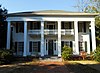 | April 13, 1989 (#89000310) | Society Hill Rd., 0.4 miles (0.64 km) north of County Highway 10 32°18′00″N 85°28′46″W / 32.3°N 85.4794°W / 32.3; -85.4794 (Creekwood) | Creek Stand | c. 1844 |
| 6 | Grey Columns |  | January 11, 1980 (#80000364) | 399 Old Montgomery Rd. 32°25′27″N 85°41′59″W / 32.424291°N 85.699596°W / 32.424291; -85.699596 (Grey Columns) | Tuskegee | Built in 1857, Grey Columns now serves as the home of the president of Tuskegee University. |
| 7 | Macon County Courthouse |  | November 17, 1978 (#78000495) | E. Northside and N. Main Sts. 32°25′28″N 85°41′27″W / 32.4244°N 85.6908°W / 32.4244; -85.6908 (Macon County Courthouse) | Tuskegee | |
| 8 | Macon County High School | 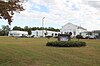 | November 16, 2020 (#100005781) | 500 East Main St. 32°33′38″N 85°39′45″W / 32.5605°N 85.6625°W / 32.5605; -85.6625 (Macon County High School) | Notasulga | Currently serves as Notasulga High School |
| 9 | Main Street Historic District |  | March 12, 1984 (#84000650) | Main St. 32°25′22″N 85°41′23″W / 32.4228°N 85.6897°W / 32.4228; -85.6897 (Main Street Historic District) | Tuskegee | |
| 10 | North Main Street Historic District |  | March 7, 1985 (#85000445) | 600, 615, and 616 N. Main, 101 and 110 E. Water, 700 Water, 701 Maple, and 811 N. Maple Sts. 32°25′46″N 85°41′40″W / 32.4294°N 85.6944°W / 32.4294; -85.6944 (North Main Street Historic District) | Tuskegee | |
| 11 | St. Paul Baptist Church and Armstrong School | Upload image | July 5, 2023 (#100009106) | 14650 Cty. Rd. 2 32°14′23″N 85°40′28″W / 32.2397°N 85.6744°W / 32.2397; -85.6744 (St. Paul Baptist Church and Armstrong School) | Tuskegee vicinity | |
| 12 | Shiloh Missionary Baptist Church and Rosenwald School |  | August 6, 2010 (#10000522) | 7 Shiloh Rd. 32°31′41″N 85°40′40″W / 32.5280°N 85.6778°W / 32.5280; -85.6778 (Shiloh Missionary Baptist Church and Rosenwald School) | Notasulga | |
| 13 | Shiloh Missionary Baptist Church Cemetery |  | April 5, 2016 (#15000433) | State Route 81 at Pistol Range Rd. 32°31′08″N 85°40′55″W / 32.5188°N 85.6819°W / 32.5188; -85.6819 (Shiloh Missionary Baptist Church Cemetery) | Notasulga | |
| 14 | Tuskegee Airmen National Historic Site |  | November 6, 1998 (#01000284) | c/o Tuskegee Institute, PO Drawer 10 32°27′33″N 85°40′48″W / 32.4592°N 85.68°W / 32.4592; -85.68 (Tuskegee Airmen National Historic Site) | Tuskegee | National Historic Landmark District, historic training site for African-American pilots and crewmen during World War II (before the US Air Force was a separate branch of the service and before desegregation). |
| 15 | Tuskegee Institute National Historic Site |  | October 15, 1966 (#66000151) | 1 mile (1.6 km) northwest of Tuskegee on U.S. Route 80 32°25′49″N 85°42′28″W / 32.4303°N 85.7078°W / 32.4303; -85.7078 (Tuskegee Institute National Historic Site) | Tuskegee | One of the best-known historically black colleges and universities in the United States, Tuskegee was founded by Booker T. Washington in 1881. It began with a curriculum designed to provide industrial and vocational education to African Americans and featured such acclaimed educators as George Washington Carver.[5] Tuskegee Institute is also a National Historic Landmark. |
| 16 | Tuskegee Veterans Administration Hospital |  | March 19, 2012 (#12000140) | 2400 Hospital Rd. 32°26′43″N 85°42′47″W / 32.4452°N 85.7131°W / 32.4452; -85.7131 (Tuskegee Veterans Administration Hospital) | Tuskegee | Part of the United States' second generation of veterans hospitals; multiple property submission. |
See also
Wikimedia Commons has media related to National Register of Historic Places in Macon County, Alabama.
- List of National Historic Landmarks in Alabama
- National Register of Historic Places listings in Alabama
References
- ^ The latitude and longitude information provided in this table was derived originally from the National Register Information System, which has been found to be fairly accurate for about 99% of listings. Some locations in this table may have been corrected to current GPS standards.
- ^ National Park Service, United States Department of the Interior, "National Register of Historic Places: Weekly List Actions", retrieved August 30, 2024.
- ^ Numbers represent an alphabetical ordering by significant words. Various colorings, defined here, differentiate National Historic Landmarks and historic districts from other NRHP buildings, structures, sites or objects.
- ^ The eight-digit number below each date is the number assigned to each location in the National Register Information System database, which can be viewed by clicking the number.
- ^ "Tuskegee Institute". National Historic Landmarks Program. National Park Service. Archived from the original on 2008-02-18. Retrieved 2008-02-22.
- v
- t
- e
by county
- Autauga
- Baldwin
- Barbour
- Bibb
- Blount
- Bullock
- Butler
- Calhoun
- Chambers
- Cherokee
- Chilton
- Choctaw
- Clarke
- Clay
- Cleburne
- Coffee
- Colbert
- Conecuh
- Coosa
- Covington
- Crenshaw
- Cullman
- Dale
- Dallas
- DeKalb
- Elmore
- Escambia
- Etowah
- Fayette
- Franklin
- Geneva
- Greene
- Hale
- Henry
- Houston
- Jackson
- Jefferson
- Lamar
- Lauderdale
- Lawrence
- Lee
- Limestone
- Lowndes
- Macon
- Madison
- Marengo
- Marion
- Marshall
- Mobile
- Monroe
- Montgomery
- Morgan
- Perry
- Pickens
- Pike
- Randolph
- Russell
- St. Clair
- Shelby
- Sumter
- Talladega
- Tallapoosa
- Tuscaloosa
- Walker
- Washington
- Wilcox
- Winston


