National Register of Historic Places listings in Etowah County, Alabama

This is a list of the National Register of Historic Places listings in Etowah County, Alabama.
This is intended to be a complete list of the properties and districts on the National Register of Historic Places in Etowah County, Alabama, United States. Latitude and longitude coordinates are provided for many National Register properties and districts; these locations may be seen together in an online map.[1]
There are 15 properties and districts listed on the National Register in the county.
This National Park Service list is complete through NPS recent listings posted August 30, 2024.[2]
Map all coordinates using OpenStreetMap
Download coordinates as:
- KML
- GPX (all coordinates)
- GPX (primary coordinates)
- GPX (secondary coordinates)
Current listings
| [3] | Name on the Register | Image | Date listed[4] | Location | City or town | Description |
|---|---|---|---|---|---|---|
| 1 | Alabama City Library |  | December 27, 1974 (#74000410) | 1 Cabot Ave. 34°01′32″N 86°02′38″W / 34.025579°N 86.043817°W / 34.025579; -86.043817 (Alabama City Library) | Gadsden | |
| 2 | Alabama City Wall Street Historic District |  | May 16, 2002 (#02000484) | Roughly along Wall St. from Norris Ave. to Meighan Boulevard 34°01′14″N 86°02′44″W / 34.020556°N 86.045556°W / 34.020556; -86.045556 (Alabama City Wall Street Historic District) | Gadsden | |
| 3 | Attalla Downtown Historic District | 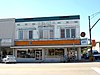 | December 11, 2013 (#13000893) | 3rd St. N., 4th St. N. & 5th Ave. S. 34°01′21″N 86°05′22″W / 34.022529°N 86.089416°W / 34.022529; -86.089416 (Attalla Downtown Historic District) | Attalla | |
| 4 | Eleventh Street School | 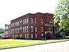 | May 10, 1984 (#84000616) | 1026 Chestnut St. 34°00′49″N 86°01′05″W / 34.013611°N 86.018056°W / 34.013611; -86.018056 (Eleventh Street School) | Gadsden | |
| 5 | Forrest Cemetery Chapel and Comfort Station |  | September 3, 1992 (#92001069) | 1100 S. 15th St. 34°00′41″N 86°01′34″W / 34.011389°N 86.026111°W / 34.011389; -86.026111 (Forrest Cemetery Chapel and Comfort Station) | Gadsden | |
| 6 | Gadsden Coca-Cola Bottling Plant | Upload image | November 17, 2023 (#100009569) | 644 Walnut Street 34°00′41″N 86°00′34″W / 34.0113°N 86.0094°W / 34.0113; -86.0094 (Gadsden Coca-Cola Bottling Plant) | Gadsden | |
| 7 | Gadsden Downtown Historic District |  | September 26, 1997 (#97001165) | Along Broad St., roughly bounded by Locust, 3rd, S. 5th, Chestnut, and 7th Sts. 34°00′49″N 86°00′17″W / 34.013611°N 86.004722°W / 34.013611; -86.004722 (Gadsden Downtown Historic District) | Gadsden | |
| 8 | Gadsden Times-News Building |  | January 11, 1983 (#83002967) | 4th and Chestnut Sts. 34°00′44″N 86°00′14″W / 34.012222°N 86.003889°W / 34.012222; -86.003889 (Gadsden Times-News Building) | Gadsden | |
| 9 | Charles Gunn House |  | February 19, 1993 (#93000052) | 872 Chestnut St. 34°00′50″N 86°00′54″W / 34.013889°N 86.015°W / 34.013889; -86.015 (Charles Gunn House) | Gadsden | |
| 10 | Colonel O.R. Hood House | 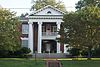 | May 8, 1986 (#86001000) | 862 Chestnut St. 34°00′50″N 86°00′51″W / 34.013859°N 86.014291°W / 34.013859; -86.014291 (Colonel O.R. Hood House) | Gadsden | |
| 11 | Legion Park Bowl | 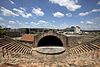 | September 28, 1988 (#88001581) | 336 1st St., S. 34°00′30″N 86°00′05″W / 34.008333°N 86.001389°W / 34.008333; -86.001389 (Legion Park Bowl) | Gadsden | |
| 12 | Noojin House and Bellevue-Mineral Springs Hotel Site | Upload image | June 27, 2023 (#100008433) | 326 Bellevue Dr. 34°01′49″N 86°01′16″W / 34.0303°N 86.0210°W / 34.0303; -86.0210 (Noojin House and Bellevue-Mineral Springs Hotel Site) | Gadsden | |
| 13 | Turrentine Historic District | 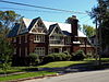 | July 6, 2005 (#05000649) | 300-633 Turrentine Ave. 34°00′31″N 86°00′51″W / 34.008611°N 86.014167°W / 34.008611; -86.014167 (Turrentine Historic District) | Gadsden | |
| 14 | U.S. Post Office | 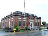 | June 21, 1983 (#83002968) | 401 4th St. 34°01′19″N 86°05′25″W / 34.021944°N 86.090278°W / 34.021944; -86.090278 (U.S. Post Office) | Attalla | |
| 15 | Campbell Professional Building |  | June 3, 1976 (#76000325) | 600 Broad St. 34°00′52″N 86°00′24″W / 34.014444°N 86.006667°W / 34.014444; -86.006667 (Campbell Professional Building) | Gadsden |
See also
Wikimedia Commons has media related to National Register of Historic Places in Etowah County, Alabama.
- List of National Historic Landmarks in Alabama
- National Register of Historic Places listings in Alabama
References
- ^ The latitude and longitude information provided in this table was derived originally from the National Register Information System, which has been found to be fairly accurate for about 99% of listings. Some locations in this table may have been corrected to current GPS standards.
- ^ National Park Service, United States Department of the Interior, "National Register of Historic Places: Weekly List Actions", retrieved August 30, 2024.
- ^ Numbers represent an alphabetical ordering by significant words. Various colorings, defined here, differentiate National Historic Landmarks and historic districts from other NRHP buildings, structures, sites or objects.
- ^ The eight-digit number below each date is the number assigned to each location in the National Register Information System database, which can be viewed by clicking the number.
- v
- t
- e
by county
- Autauga
- Baldwin
- Barbour
- Bibb
- Blount
- Bullock
- Butler
- Calhoun
- Chambers
- Cherokee
- Chilton
- Choctaw
- Clarke
- Clay
- Cleburne
- Coffee
- Colbert
- Conecuh
- Coosa
- Covington
- Crenshaw
- Cullman
- Dale
- Dallas
- DeKalb
- Elmore
- Escambia
- Etowah
- Fayette
- Franklin
- Geneva
- Greene
- Hale
- Henry
- Houston
- Jackson
- Jefferson
- Lamar
- Lauderdale
- Lawrence
- Lee
- Limestone
- Lowndes
- Macon
- Madison
- Marengo
- Marion
- Marshall
- Mobile
- Monroe
- Montgomery
- Morgan
- Perry
- Pickens
- Pike
- Randolph
- Russell
- St. Clair
- Shelby
- Sumter
- Talladega
- Tallapoosa
- Tuscaloosa
- Walker
- Washington
- Wilcox
- Winston

Municipalities and communities of Etowah County, Alabama, United States | ||
|---|---|---|
County seat: Gadsden | ||
| Cities |  | |
| Towns | ||
| CDPs | ||
| Unincorporated communities | ||
| Former City | ||
| Footnotes | ‡This populated place also has portions in an adjacent county or counties | |
| ||


