National Register of Historic Places listings in Lawrence County, Alabama

This is a list of the National Register of Historic Places listings in Lawrence County, Alabama.
This is intended to be a complete list of the properties and districts on the National Register of Historic Places in Lawrence County, Alabama, United States. Latitude and longitude coordinates are provided for many National Register properties and districts; these locations may be seen together in a Google map.[1]
There are 11 properties and districts listed on the National Register in the county.
This National Park Service list is complete through NPS recent listings posted August 30, 2024.[2]
Map all coordinates using OpenStreetMap
Download coordinates as:
- KML
- GPX (all coordinates)
- GPX (primary coordinates)
- GPX (secondary coordinates)
Current listings
| [3] | Name on the Register | Image | Date listed[4] | Location | City or town | Description |
|---|---|---|---|---|---|---|
| 1 | Archeological Site No. 1LA102 | Upload image | December 14, 1985 (#85003117) | Address Restricted | Haleyville | |
| 2 | Boxwood Plantation Slave Quarter | 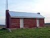 | July 10, 2013 (#13000470) | 20416 AL 20 34°38′02″N 87°06′49″W / 34.633966°N 87.113708°W / 34.633966; -87.113708 (Boxwood Plantation Slave Quarter) | Courtland | |
| 3 | Bride's Hill |  | July 9, 1986 (#86001544) | Lock Rd. 34°40′13″N 87°14′40″W / 34.670278°N 87.244444°W / 34.670278; -87.244444 (Bride's Hill) | Wheeler | |
| 4 | Courtland Historic District |  | May 13, 1991 (#91000597) | Roughly bounded by Clinton, Madison, Van Buren, Jefferson, Ussery, Tennessee, Monroe and Academy Sts. 34°40′03″N 87°18′34″W / 34.6675°N 87.309444°W / 34.6675; -87.309444 (Courtland Historic District) | Courtland | Includes a boundary increase on June 26, 1998 |
| 5 | Goode-Hall House |  | October 1, 1974 (#74000418) | North of Town Creek off State Route 101 34°43′31″N 87°23′24″W / 34.725278°N 87.39°W / 34.725278; -87.39 (Goode-Hall House) | Town Creek | |
| 6 | Thomas Holland House |  | October 1, 1991 (#91001478) | Off Alternate U.S. Route 72 south of Hillsboro 34°35′45″N 87°12′20″W / 34.59583°N 87.20556°W / 34.59583; -87.20556 (Thomas Holland House) | Hillsboro | Destroyed by fire in 1997 |
| 7 | Ice House |  | June 22, 2000 (#00000712) | 844 Seminary St. 34°28′56″N 87°17′24″W / 34.48224°N 87.289885°W / 34.48224; -87.289885 (Ice House) | Moulton | |
| 8 | John McMahon House | 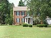 | December 11, 1987 (#87001454) | Junction of South Lane and Jefferson St. 34°40′07″N 87°18′21″W / 34.668611°N 87.305833°W / 34.668611; -87.305833 (John McMahon House) | Courtland | |
| 9 | Moulton Courthouse Square Historic District |  | August 14, 1998 (#98001026) | Roughly bounded by Lawrence, Main, Court, and Market Sts. 34°28′52″N 87°17′30″W / 34.481111°N 87.291667°W / 34.481111; -87.291667 (Moulton Courthouse Square Historic District) | Moulton | |
| 10 | Wheeler Hydroelectric Project |  | July 26, 2016 (#16000431) | 24455 AL 101 34°48′22″N 87°22′55″W / 34.80623°N 87.38188°W / 34.80623; -87.38188 (Wheeler Hydroelectric Project) | Rogersville | |
| 11 | Joseph Wheeler Plantation | 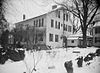 | April 13, 1977 (#77000209) | East of Courtland off State Route 20 34°38′56″N 87°15′21″W / 34.648889°N 87.255833°W / 34.648889; -87.255833 (Joseph Wheeler Plantation) | Wheeler |
See also
Wikimedia Commons has media related to National Register of Historic Places in Lawrence County, Alabama.
- List of National Historic Landmarks in Alabama
- National Register of Historic Places listings in Alabama
References
- ^ The latitude and longitude information provided in this table was derived originally from the National Register Information System, which has been found to be fairly accurate for about 99% of listings. Some locations in this table may have been corrected to current GPS standards.
- ^ National Park Service, United States Department of the Interior, "National Register of Historic Places: Weekly List Actions", retrieved August 30, 2024.
- ^ Numbers represent an alphabetical ordering by significant words. Various colorings, defined here, differentiate National Historic Landmarks and historic districts from other NRHP buildings, structures, sites or objects.
- ^ The eight-digit number below each date is the number assigned to each location in the National Register Information System database, which can be viewed by clicking the number.
- v
- t
- e
by county
- Autauga
- Baldwin
- Barbour
- Bibb
- Blount
- Bullock
- Butler
- Calhoun
- Chambers
- Cherokee
- Chilton
- Choctaw
- Clarke
- Clay
- Cleburne
- Coffee
- Colbert
- Conecuh
- Coosa
- Covington
- Crenshaw
- Cullman
- Dale
- Dallas
- DeKalb
- Elmore
- Escambia
- Etowah
- Fayette
- Franklin
- Geneva
- Greene
- Hale
- Henry
- Houston
- Jackson
- Jefferson
- Lamar
- Lauderdale
- Lawrence
- Lee
- Limestone
- Lowndes
- Macon
- Madison
- Marengo
- Marion
- Marshall
- Mobile
- Monroe
- Montgomery
- Morgan
- Perry
- Pickens
- Pike
- Randolph
- Russell
- St. Clair
- Shelby
- Sumter
- Talladega
- Tallapoosa
- Tuscaloosa
- Walker
- Washington
- Wilcox
- Winston


