Sawley, Lancashire
Human settlement in England
- Sawley
- Ribble Valley
- Lancashire
- North West
- Ribble Valley
- List of places
- UK
- England
- Lancashire
Sawley is a village and civil parish in the Borough of Ribble Valley in Lancashire, England. The population of the civil parish was 305 at the 2001 Census,[2] rising to 345 at the 2011 census.[1] It is situated north-east of Clitheroe, on the River Ribble. It was historically part of the West Riding of Yorkshire.
The parish adjoins the Ribble Valley parishes of Bolton-by-Bowland, Paythorne, Gisburn, Rimington, Downham, Chatburn and Grindleton.
History
Historically, Sawley fell under the Earl of Northumberland's Percy fee rather than being part of the neighbouring Lordship of Bowland.[3] Sawley Abbey, a ruined abbey of Cistercian monks, is in the village. The abbey was founded in 1147 and dissolved in 1536.[4] By the early 17th-century, the manor had come into the possession of James Hay, who in 1615 was created Lord Hay of Sawley, and later 1st Earl of Carlisle.[5]
Governance
Sawley was an extra-parochial area in the Staincliffe Wapentake of the West Riding of Yorkshire. This became a civil parish in 1858, forming part of the Bowland Rural District from 1894 to 1974. The civil parish previously had a detached area on the southern side of Gisburn with a smaller part of that parish on the western side of Sawley. In 1938 these areas were joined with the respective parishes.[6] It has since become part of the Lancashire borough of Ribble Valley. Sawley shares a parish council with two other parishes, Bolton-by-Bowland and Gisburn Forest.[7]
Along with Waddington, West Bradford and Grindleton, the parish forms the Waddington and West Bradford ward of Ribble Valley Borough Council. [8][9]
Media gallery
-
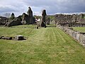 The ruins of Sawley Abbey.
 -
 Sawley Bridge on the River Ribble.
 -
 Former Sawley School, now the Village Hall.
 -
 The Spread Eagle.
 -
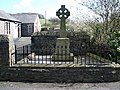 War Memorial.
 -
 Sawley Grange Farm.


See also
 Lancashire portal

References
- ^ a b UK Census (2011). "Local Area Report – Sawley Parish (1170215130)". Nomis. Office for National Statistics. Retrieved 8 February 2018.
- ^ "Parish headcount" (PDF). Lancashire Parish Portal. Lancashire County Council. Archived from the original (PDF) on 10 December 2006. Retrieved 20 September 2008.
- ^ The Lordship of Bowland http://www.forestofbowland.com/node/1864
- ^ Historic England. "Sawley Abbey (1072099)". National Heritage List for England. Retrieved 20 September 2008.
- ^ Whitaker, Thomas Dunham (1878), The history and antiquities of the deanery of Craven 3rd ed., Dodson (Leeds) and Cassell, Petter & Galpin (London), pp. 71–2, OCLC 504073084
- ^ "Sawley CP/ExP through time". visionofbritain.org.uk. GB Historical GIS / University of Portsmouth. Retrieved 25 March 2016.
- ^ "Bolton-by-Bowland, Gisburn Forest and Sawley Parish Council". Lancashire Parish Portal. Lancashire County Council. Archived from the original on 7 January 2006. Retrieved 20 September 2008.
- ^ "Waddington and West Bradford". MARIO. Lancashire County Council. Retrieved 25 March 2016.
- ^ "Waddington and West Bradford". Ordnance Survey Linked Data Platform. Ordnance Survey. Retrieved 25 March 2016.
External links
![]() Media related to Sawley, Lancashire at Wikimedia Commons
Media related to Sawley, Lancashire at Wikimedia Commons
- Sawley Conservation Area Appraisal
- v
- t
- e
Geography of the Borough of Ribble Valley
& suburbs
- Balderstone
- Barrow
- Bashall Eaves
- Billington
- Bolton-by-Bowland
- Brockhall Village
- Chatburn
- Chipping
- Clayton-le-Dale
- Dinckley
- Downham
- Dunsop Bridge
- Gisburn
- Great Mitton
- Grindleton
- Horton
- Hurst Green
- Langho
- Low Moor
- Mellor Brook
- Mellor
- Middop
- Newsholme
- Newton
- Osbaldeston
- Paythorne
- Pendleton
- Read
- Ribchester
- Rimington
- Sabden
- Salesbury
- Sawley
- Simonstone
- Slaidburn
- Stydd
- Tosside
- Twiston
- Waddington
- West Bradford
- Whalley
- Whitewell
- Wilpshire
- Wiswell
- Worston
- York
- Aighton, Bailey and Chaigley
- Balderstone
- Bashall Eaves
- Billington and Langho
- Bolton-by-Bowland
- Bowland Forest High
- Bowland Forest Low
- Bowland-with-Leagram
- Chatburn
- Chipping
- Clayton-le-Dale
- Clitheroe
- Dinckley
- Downham
- Dutton
- Easington
- Gisburn
- Gisburn Forest
- Great Mitton
- Grindleton
- Horton
- Hothersall
- Little Mitton
- Longridge
- Mearley
- Mellor
- Middop
- Newsholme
- Newton
- Osbaldeston
- Paythorne
- Pendleton
- Ramsgreave
- Read
- Ribchester
- Rimington
- Sabden
- Salesbury
- Sawley
- Simonstone
- Slaidburn
- Thornley-with-Wheatley
- Twiston
- Waddington
- West Bradford
- Whalley
- Wilpshire
- Wiswell
- Worston
| Footpaths | |
|---|---|
| Hills | |
| Waterways | |
Authority control databases | |
|---|---|
| International |
|
| National |
|
 | This Lancashire location article is a stub. You can help Wikipedia by expanding it. |
- v
- t
- e


