National Register of Historic Places listings in Power County, Idaho

This is a list of the National Register of Historic Places listings in Power County, Idaho.
This is intended to be a complete list of the properties and districts on the National Register of Historic Places in Power County, Idaho, United States. Latitude and longitude coordinates are provided for many National Register properties and districts; these locations may be seen together in a map.[1]
There are 12 properties and districts listed on the National Register in the county. More may be added; properties and districts nationwide are added to the Register weekly.[2]
This National Park Service list is complete through NPS recent listings posted July 12, 2024.[3]
Map all coordinates using OpenStreetMap
Download coordinates as:
- KML
- GPX (all coordinates)
- GPX (primary coordinates)
- GPX (secondary coordinates)
Current listings
| [4] | Name on the Register[5] | Image | Date listed[6] | Location | City or town | Description |
|---|---|---|---|---|---|---|
| 1 | American Falls Archeological District |  | July 1, 1999 (#99000804) | Address Restricted[7] | American Falls | |
| 2 | American Falls East Shore Power Plants | 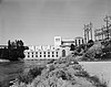 | October 29, 1976 (#76000680) | State Highway 39 42°46′34″N 112°52′27″W / 42.776111°N 112.874167°W / 42.776111; -112.874167 (American Falls East Shore Power Plants) | American Falls | |
| 3 | American Falls Reservoir Flooded Townsite | Upload image | January 28, 2002 (#01001480) | American Falls Reservoir 42°47′31″N 112°51′55″W / 42.791944°N 112.865278°W / 42.791944; -112.865278 (American Falls Reservoir Flooded Townsite) | American Falls | |
| 4 | Bethany Deaconess Hospital | 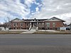 | April 27, 1995 (#95000507) | 500 Pocatello Highway Ave. 42°47′02″N 112°50′53″W / 42.783889°N 112.848056°W / 42.783889; -112.848056 (Bethany Deaconess Hospital) | American Falls | |
| 5 | William Davie House |  | April 2, 2008 (#08000252) | 703 Hutchinson Ave. 42°46′53″N 112°51′18″W / 42.78137°N 112.85489°W / 42.78137; -112.85489 (William Davie House) | American Falls | |
| 6 | Oneida Milling and Elevator Company Grain Elevator | 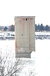 | July 16, 1993 (#93000380) | Offshore in American Falls Reservoir 42°47′05″N 112°52′04″W / 42.784722°N 112.867778°W / 42.784722; -112.867778 (Oneida Milling and Elevator Company Grain Elevator) | American Falls | |
| 7 | Oregon Trail Historic District |  | March 20, 1973 (#73000688) | Southwest of American Falls along U.S. Route 30N, and west of American Falls 42°39′16″N 113°02′38″W / 42.654444°N 113.043889°W / 42.654444; -113.043889 (Oregon Trail Historic District) | American Falls | "West of American Falls" represents a boundary increase |
| 8 | Power County Courthouse |  | September 22, 1987 (#87001601) | 543 Bannock Ave. 42°46′59″N 112°50′55″W / 42.783056°N 112.848611°W / 42.783056; -112.848611 (Power County Courthouse) | American Falls | |
| 9 | Register Rock |  | July 24, 1978 (#78001097) | West of American Falls on U.S. Route 30 42°39′10″N 113°00′58″W / 42.652778°N 113.016111°W / 42.652778; -113.016111 (Register Rock) | American Falls | |
| 10 | St. John's Episcopal Church | 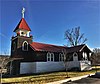 | February 7, 2007 (#07000004) | 328 Roosevelt St. 42°46′56″N 112°51′04″W / 42.782222°N 112.851111°W / 42.782222; -112.851111 (St. John's Episcopal Church) | American Falls | |
| 11 | Walter Sparks House | 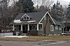 | February 7, 2007 (#07000002) | 408 Roosevelt St. 42°46′55″N 112°50′58″W / 42.781944°N 112.849444°W / 42.781944; -112.849444 (Walter Sparks House) | American Falls | |
| 12 | Richard and Winnie Warwas House |  | August 31, 2006 (#06000741) | 275 Polk St. 42°46′53″N 112°51′11″W / 42.781389°N 112.853056°W / 42.781389; -112.853056 (Richard and Winnie Warwas House) | American Falls |
See also
Wikimedia Commons has media related to National Register of Historic Places in Power County, Idaho.
References
- ^ The latitude and longitude information provided in this table was derived originally from the National Register Information System, which has been found to be fairly accurate for about 99% of listings. Some locations in this table may have been corrected to current GPS standards.
- ^ "National Register of Historic Places: Weekly List Actions". National Park Service. Retrieved March 29, 2009.
- ^ National Park Service, United States Department of the Interior, "National Register of Historic Places: Weekly List Actions", retrieved July 12, 2024.
- ^ Numbers represent an alphabetical ordering by significant words. Various colorings, defined here, differentiate National Historic Landmarks and historic districts from other NRHP buildings, structures, sites or objects.
- ^ "National Register Information System". National Register of Historic Places. National Park Service. April 24, 2008.
- ^ The eight-digit number below each date is the number assigned to each location in the National Register Information System database, which can be viewed by clicking the number.
- ^ Some listings on the NRHP are highly sensitive sites and may be subject to looting or vandalism. The NRHP lists this site as "Address Restricted."
- v
- t
- e
- Ada
- Adams
- Bannock
- Bear Lake
- Benewah
- Bingham
- Blaine
- Boise
- Bonner
- Bonneville
- Boundary
- Butte
- Camas
- Canyon
- Caribou
- Cassia
- Clark
- Clearwater
- Custer
- Elmore
- Franklin
- Fremont
- Gem
- Gooding
- Idaho
- Jefferson
- Jerome
- Kootenai
- Latah
- Lemhi
- Lewis
- Lincoln
- Madison
- Minidoka
- Nez Perce
- Oneida
- Owyhee
- Payette
- Power
- Shoshone
- Teton
- Twin Falls
- Valley
- Washington

| |
|---|---|
| Topics | |
| Lists by state |
|
| Lists by insular areas | |
| Lists by associated state | |
| Other areas | |
| Related | |
| |


Municipalities and communities of Power County, Idaho, United States | ||
|---|---|---|
County seat: American Falls | ||
| Cities |  | |
| CDP | ||
| Unincorporated communities | ||
| Indian reservation | ||
| Footnotes | ‡This populated place also has portions in an adjacent county or counties | |
| ||


