National Register of Historic Places listings in Harrison County, Iowa

This is intended to be a complete list of the properties and districts on the National Register of Historic Places in Harrison County, Iowa, United States. Latitude and longitude coordinates are provided for many National Register properties and districts; these locations may be seen together in a map.[1]
There are 13 properties and districts listed on the National Register in the county, including one National Historic Landmark.
This National Park Service list is complete through NPS recent listings posted September 5, 2024.[2]
Map all coordinates using OpenStreetMap
Download coordinates as:
- KML
- GPX (all coordinates)
- GPX (primary coordinates)
- GPX (secondary coordinates)
| [3] | Name on the Register[4] | Image | Date listed[5] | Location | City or town | Description |
|---|---|---|---|---|---|---|
| 1 | William Haner Polygonal Barn | Upload image | June 30, 1986 (#86001435) | County Road L16 41°49′14″N 95°49′25″W / 41.820556°N 95.823611°W / 41.820556; -95.823611 (William Haner Polygonal Barn) | Pisgah | |
| 2 | Harrison County Courthouse |  | July 2, 1981 (#81000243) | 7th St. 41°38′37″N 95°47′23″W / 41.643611°N 95.789722°W / 41.643611; -95.789722 (Harrison County Courthouse) | Logan | |
| 3 | I.O.O.F. Hall |  | June 23, 2011 (#11000391) | 613-615 Iowa Ave. 41°51′16″N 95°36′03″W / 41.854451°N 95.60083°W / 41.854451; -95.60083 (I.O.O.F. Hall) | Dunlap | |
| 4 | Modale School and Masonic Hall | Upload image | February 5, 2014 (#13001136) | 107 S. Main St. 41°37′09″N 96°00′44″W / 41.619028°N 96.012278°W / 41.619028; -96.012278 (Modale School and Masonic Hall) | Modale | |
| 5 | Murray General Merchandise Store | Upload image | July 31, 1998 (#98000930) | Junction of Mulberry and 2nd Sts. 41°48′34″N 96°01′28″W / 41.8095°N 96.024583°W / 41.8095; -96.024583 (Murray General Merchandise Store) | Little Sioux | |
| 6 | Old Harrison County Courthouse | Upload image | February 24, 1983 (#83000365) | 401 Locust 41°41′39″N 95°52′17″W / 41.694083°N 95.871361°W / 41.694083; -95.871361 (Old Harrison County Courthouse) | Magnolia | |
| 7 | Siebels' Department Store-Boyer Valley Bank |  | June 6, 2012 (#12000327) | 501-505 Walker St. 41°44′14″N 95°42′08″W / 41.737336°N 95.702357°W / 41.737336; -95.702357 (Siebels' Department Store-Boyer Valley Bank) | Woodbine | |
| 8 | State Savings Bank |  | April 18, 1985 (#85000836) | 312 E. 7th St. 41°38′34″N 95°47′15″W / 41.642778°N 95.787583°W / 41.642778; -95.787583 (State Savings Bank) | Logan | |
| 9 | John R. Wheeler Jr. House | Upload image | November 4, 1986 (#86003171) | 407 S. 3rd St. 41°51′04″N 95°36′11″W / 41.851111°N 95.603194°W / 41.851111; -95.603194 (John R. Wheeler Jr. House) | Dunlap | |
| 10 | Woodbine Lincoln Highway and Brick Street Historic District | 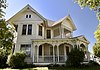 | January 29, 2013 (#12001083) | 101–524 Lincoln Way, 303–524 Walker, parts of 5th, 4th, & 3rd Sts. 41°44′10″N 95°42′11″W / 41.73625°N 95.703167°W / 41.73625; -95.703167 (Woodbine Lincoln Highway and Brick Street Historic District) | Woodbine | |
| 11 | Woodbine Normal and Grade School |  | November 18, 2002 (#02001227) | 5th and Weare 41°44′15″N 95°42′24″W / 41.7375°N 95.706667°W / 41.7375; -95.706667 (Woodbine Normal and Grade School) | Woodbine | |
| 12 | Woodbine Public Library | 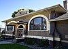 | May 23, 1997 (#97000462) | 58 5th St. 41°44′13″N 95°42′13″W / 41.736833°N 95.7035°W / 41.736833; -95.7035 (Woodbine Public Library) | Woodbine | |
| 13 | Woodbine Savings Bank | 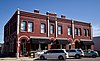 | March 27, 2012 (#12000167) | 424 Walker St. 41°44′11″N 95°42′07″W / 41.736263°N 95.702033°W / 41.736263; -95.702033 (Woodbine Savings Bank) | Woodbine |
Former listings
| [3] | Name on the Register | Image | Date listed | Date removed | Location | City or town | Description |
|---|---|---|---|---|---|---|---|
| 1 | Harrison County Jail | Upload image | April 14, 1983 (#83004517) | May 10, 2006 | 105 South First Avenue | Logan |
See also
Wikimedia Commons has media related to National Register of Historic Places in Harrison County, Iowa.
- List of National Historic Landmarks in Iowa
- National Register of Historic Places listings in Iowa
- Listings in neighboring counties: Burt (NE), Crawford, Monona, Pottawattamie, Washington (NE)
References
- ^ The latitude and longitude information provided in this table was derived originally from the National Register Information System, which has been found to be fairly accurate for about 99% of listings. Some locations in this table may have been corrected to current GPS standards.
- ^ National Park Service, United States Department of the Interior, "National Register of Historic Places: Weekly List Actions", retrieved September 5, 2024.
- ^ a b Numbers represent an alphabetical ordering by significant words. Various colorings, defined here, differentiate National Historic Landmarks and historic districts from other NRHP buildings, structures, sites or objects.
- ^ "National Register Information System". National Register of Historic Places. National Park Service. April 24, 2008.
- ^ The eight-digit number below each date is the number assigned to each location in the National Register Information System database, which can be viewed by clicking the number.
- v
- t
- e
- List of U.S. National Historic Landmarks by state:
- Alabama
- Alaska
- Arizona
- Arkansas
- California
- Colorado
- Connecticut
- Delaware
- Florida
- Georgia
- Hawaii
- Idaho
- Illinois
- Indiana
- Iowa
- Kansas
- Kentucky
- Louisiana
- Maine
- Maryland
- Massachusetts
- Michigan
- Minnesota
- Mississippi
- Missouri
- Montana
- Nebraska
- Nevada
- New Hampshire
- New Jersey
- New Mexico
- New York
- North Carolina
- North Dakota
- Ohio
- Oklahoma
- Oregon
- Pennsylvania
- Rhode Island
- South Carolina
- South Dakota
- Tennessee
- Texas
- Utah
- Vermont
- Virginia
- Washington
- West Virginia
- Wisconsin
- Wyoming
 National Register of Historic Places portal
 Category


