National Register of Historic Places listings in Carroll County, Iowa

This is a list of the National Register of Historic Places listings in Carroll County, Iowa.
This is intended to be a complete list of the properties and districts on the National Register of Historic Places in Carroll County, Iowa, United States. Latitude and longitude coordinates are provided for many National Register properties and districts; these locations may be seen together in a map.[1]
There are 19 properties and districts listed on the National Register in the county.
This National Park Service list is complete through NPS recent listings posted August 30, 2024.[2]
Map all coordinates using OpenStreetMap
Download coordinates as:
- KML
- GPX (all coordinates)
- GPX (primary coordinates)
- GPX (secondary coordinates)
| [3] | Name on the Register[4] | Image | Date listed[5] | Location | City or town | Description |
|---|---|---|---|---|---|---|
| 1 | American Express Building-Carroll | 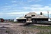 | September 6, 1990 (#90001299) | Junction of N. West and W. 5th Sts. 42°03′55″N 94°52′18″W / 42.065278°N 94.871667°W / 42.065278; -94.871667 (American Express Building-Carroll) | Carroll | |
| 2 | Armour Creameries Poultry House | Upload image | November 18, 2011 (#11000815) | 218 5th Ave. S. 41°52′10″N 94°40′39″W / 41.869497°N 94.677461°W / 41.869497; -94.677461 (Armour Creameries Poultry House) | Coon Rapids | |
| 3 | Carnegie Library Building | Upload image | November 13, 1976 (#76000739) | 125 E. 6th St. 42°03′58″N 94°51′58″W / 42.066111°N 94.866111°W / 42.066111; -94.866111 (Carnegie Library Building) | Carroll | |
| 4 | Carroll City-Mount Olivet Cemetery | Upload image | February 10, 2022 (#100007432) | South Grant Rd. 42°03′21″N 94°51′38″W / 42.055849°N 94.860583°W / 42.055849; -94.860583 (Carroll City-Mount Olivet Cemetery) | Carroll | |
| 5 | Chicago & Northwestern Passenger Depot and Baggage Room-Carroll | 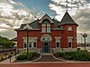 | September 6, 1990 (#90001302) | Junction of N. West and W. 5th Sts. 42°03′56″N 94°52′21″W / 42.065556°N 94.8725°W / 42.065556; -94.8725 (Chicago & Northwestern Passenger Depot and Baggage Room-Carroll) | Carroll | |
| 6 | Fobes Octagon Barn | Upload image | June 30, 1986 (#86001420) | Iowa Highway 286 42°08′14″N 94°42′30″W / 42.137222°N 94.708333°W / 42.137222; -94.708333 (Fobes Octagon Barn) | Lanesboro | |
| 7 | Graham Park Historic District | Upload image | May 23, 2024 (#100010399) | North Grant Road 42°04′03″N 94°51′35″W / 42.0676°N 94.8597°W / 42.0676; -94.8597 (Graham Park Historic District) | Carroll | |
| 8 | Holy Guardian Angels Church and Cemetery Historic District | Upload image | May 9, 2019 (#04001424) | Jade Ave. and 245th St. 42°00′01″N 94°55′02″W / 42.0003°N 94.9172°W / 42.0003; -94.9172 (Holy Guardian Angels Church and Cemetery Historic District) | Roselle | |
| 9 | Kittyhawk Avenue Bridge | Upload image | June 25, 1998 (#98000749) | Kittyhawk Ave. over an unnamed stream 42°01′47″N 94°53′52″W / 42.029722°N 94.897778°W / 42.029722; -94.897778 (Kittyhawk Avenue Bridge) | Carroll | |
| 10 | William A. Leet and Frederick Hassler Farmstead District | Upload image | May 5, 1999 (#99000526) | 12196 311th St. 41°54′19″N 95°02′58″W / 41.905278°N 95.049444°W / 41.905278; -95.049444 (William A. Leet and Frederick Hassler Farmstead District) | Manning | |
| 11 | Manning Commercial Historic District | 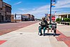 | October 23, 2015 (#15000745) | 217-411, 413-507, 302-326 Main, 717-723 3rd, 303 Center & 825 5th Sts. 41°54′32″N 95°03′54″W / 41.909°N 95.0651°W / 41.909; -95.0651 (Manning Commercial Historic District) | Manning | |
| 12 | Manning Milwaukee Railroad Trestle | Upload image | August 21, 2020 (#100005487) | Crosses Railroad/Center St., 682 ft. north of Julia St. 41°54′50″N 95°03′48″W / 41.913962°N 95.063459°W / 41.913962; -95.063459 (Manning Milwaukee Railroad Trestle) | Manning | |
| 13 | Manning Water Tower | Upload image | May 31, 2016 (#16000296) | 620 3rd Street 41°54′32″N 95°03′47″W / 41.908838°N 95.063187°W / 41.908838; -95.063187 (Manning Water Tower) | Manning | |
| 14 | Olympic Avenue Bridge | Upload image | June 25, 1998 (#98000747) | Olympic Avenue over an unnamed stream 42°06′53″N 94°48′45″W / 42.114722°N 94.8125°W / 42.114722; -94.8125 (Olympic Avenue Bridge) | Carroll | |
| 15 | Quail Avenue Bridge | Upload image | June 25, 1998 (#98000750) | Quail Ave. over an unnamed stream 42°01′50″N 94°47′00″W / 42.030556°N 94.783333°W / 42.030556; -94.783333 (Quail Avenue Bridge) | Carroll | |
| 16 | Robin Avenue Bridge | Upload image | June 25, 1998 (#98000748) | Robin Ave. over an unnamed stream 42°05′51″N 94°45′51″W / 42.0975°N 94.764167°W / 42.0975; -94.764167 (Robin Avenue Bridge) | Carroll | Replaced in 2013. |
| 17 | Storm Creek Bridge | Upload image | June 25, 1998 (#98000744) | Phoenix Ave. over Storm Creek 42°06′07″N 94°48′11″W / 42.101944°N 94.803056°W / 42.101944; -94.803056 (Storm Creek Bridge) | Carroll | |
| 18 | Storm Creek Bridge 2 | Upload image | June 25, 1998 (#98000746) | 190th St. over Storm Creek 42°04′42″N 94°46′49″W / 42.078333°N 94.780278°W / 42.078333; -94.780278 (Storm Creek Bridge 2) | Carroll |
Former listings
| [3] | Name on the Register | Image | Date listed | Date removed | Location | City or town | Description |
|---|---|---|---|---|---|---|---|
| 1 | Coon Rapids Bridge | Upload image | June 25, 1998 (#98000745) | October 15, 2014 | Sumpter Ave. over the Middle Raccoon River 41°51′54″N 94°40′38″W / 41.865°N 94.677222°W / 41.865; -94.677222 (Coon Rapids Bridge) | Coon Rapids |
See also
Wikimedia Commons has media related to National Register of Historic Places in Carroll County, Iowa.
- List of National Historic Landmarks in Iowa
- National Register of Historic Places listings in Iowa
- Listings in neighboring counties: Audubon, Calhoun, Crawford, Greene, Guthrie, Sac
References
- ^ The latitude and longitude information provided in this table was derived originally from the National Register Information System, which has been found to be fairly accurate for about 99% of listings. Some locations in this table may have been corrected to current GPS standards.
- ^ National Park Service, United States Department of the Interior, "National Register of Historic Places: Weekly List Actions", retrieved August 30, 2024.
- ^ a b Numbers represent an alphabetical ordering by significant words. Various colorings, defined here, differentiate National Historic Landmarks and historic districts from other NRHP buildings, structures, sites or objects.
- ^ "National Register Information System". National Register of Historic Places. National Park Service. April 24, 2008.
- ^ The eight-digit number below each date is the number assigned to each location in the National Register Information System database, which can be viewed by clicking the number.
- v
- t
- e
- List of U.S. National Historic Landmarks by state:
- Alabama
- Alaska
- Arizona
- Arkansas
- California
- Colorado
- Connecticut
- Delaware
- Florida
- Georgia
- Hawaii
- Idaho
- Illinois
- Indiana
- Iowa
- Kansas
- Kentucky
- Louisiana
- Maine
- Maryland
- Massachusetts
- Michigan
- Minnesota
- Mississippi
- Missouri
- Montana
- Nebraska
- Nevada
- New Hampshire
- New Jersey
- New Mexico
- New York
- North Carolina
- North Dakota
- Ohio
- Oklahoma
- Oregon
- Pennsylvania
- Rhode Island
- South Carolina
- South Dakota
- Tennessee
- Texas
- Utah
- Vermont
- Virginia
- Washington
- West Virginia
- Wisconsin
- Wyoming
 National Register of Historic Places portal
 Category


