Dhanbari Upazila
You can help expand this article with text translated from the corresponding article in Bangla. (January 2020) Click [show] for important translation instructions.
- View a machine-translated version of the Bangla article.
- Machine translation, like DeepL or Google Translate, is a useful starting point for translations, but translators must revise errors as necessary and confirm that the translation is accurate, rather than simply copy-pasting machine-translated text into the English Wikipedia.
- Do not translate text that appears unreliable or low-quality. If possible, verify the text with references provided in the foreign-language article.
- You must provide copyright attribution in the edit summary accompanying your translation by providing an interlanguage link to the source of your translation. A model attribution edit summary is
Content in this edit is translated from the existing Bangla Wikipedia article at [[:bn:ধনবাড়ী উপজেলা]]; see its history for attribution. - You may also add the template
{{Translated|bn|ধনবাড়ী উপজেলা}}to the talk page. - For more guidance, see Wikipedia:Translation.
Upazila in Dhaka, Bangladesh
Dhanbari ধনবাড়ী | |
|---|---|
Upazila | |
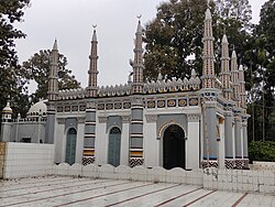 Dhanbari Mosque | |
 | |
| Coordinates: 24°37′N 90°1.5′E / 24.617°N 90.0250°E / 24.617; 90.0250 | |
| Country |  Bangladesh Bangladesh |
| Division | Dhaka |
| District | Tangail |
| Headquarters | Dhanbari |
| Area | |
| • Total | 133.75 km2 (51.64 sq mi) |
| Population (2011) | |
| • Total | 176,068 |
| • Density | 1,300/km2 (3,400/sq mi) |
| Time zone | UTC+6 (BST) |
| Website | dhanbari |
Dhanbari (Bengali: ধনবাড়ী) is an upazila under Tangail District in the Dhaka Division, Bangladesh. It was established when former Madhupur Upazila was split into two upazilas in 2006 by the efforts of Fakir Mahbub Anam Swapan, Central BNP leader who contested two times as a candidate of BNP in the constituency Tangail-1 (Madhupur-Dhanbari). Former prime Minister Begum Khaleda Zia laid the foundation of this newly formed upazila.
Demographics
| Religions in Dhanbari upazila (2011)[1] | ||||
|---|---|---|---|---|
| Religion | Percent | |||
| Islam | 97.30% | |||
| Hinduism | 2.65% | |||
| Other or not stated | 0.05% | |||
According to the 2011 Bangladesh census, Dhanbari Upazila had 45,948 households and a population of 176,068. 36,851 (20.93%) were under 10 years of age. Dhanbari had a literacy rate (age 7 and over) of 44.00%, compared to the national average of 51.8%, and a sex ratio of 1051 females per 1000 males. 36,125 (20.52%) lived in urban areas.[1][2]
Administration
Dhanbari Upazila is divided into Dhanbari Municipality and seven union parishads: Baniajan, Birtara, Bolibhadra, Dhopakhali, Jodunathpur, Musuddi, and Paiska. The union parishads are subdivided into 103 mauzas and 132 villages.
Dhanbari Municipality is subdivided into 9 wards and 25 mahallas.
Education
There are seven colleges in the upazila: Asya Hasan Ali Mohila Degree College, Bhai Ghat Ideal College, Dhanbari College, Mushuddi Razia College, Norilla College, Panchpotol Degree College, and Ukhariabari College.[3]
According to Banglapedia, Govt. Dhanbari Nawab Institution, founded in 1910, Paiska High School (1960), and Pankata Islamia Secondary School (1943) are notable secondary schools.[4]
Notable people
- Nawab Syed Ali Hasan Ali Choudhury
- Dr. Sheikh Nizamul Islam, MP
- Syeda Ashika Akbar, MP
- Dr. Abdur Razzaq, MP
See also
References
- ^ a b "Bangladesh Population and Housing Census 2011 Zila Report – Tangail" (PDF). bbs.gov.bd. Bangladesh Bureau of Statistics.
- ^ "Community Tables: Tangail district" (PDF). bbs.gov.bd. Bangladesh Bureau of Statistics. 2011.
- ^ "List of Colleges". Department of Secondary and Higher Education. Retrieved 6 September 2020.
- ^ Sajida Begum (2012), "Dhanbari Upazila", in Sirajul Islam; Ahmed A. Jamal (eds.), Banglapedia: National Encyclopedia of Bangladesh (Second ed.), Asiatic Society of Bangladesh
- v
- t
- e


 | This Dhaka Division location article is a stub. You can help Wikipedia by expanding it. |
- v
- t
- e


