Boston Harbor Islands National and State Park
Group of islands in Boston, Massachusetts
42°19′7″N 70°56′45″W / 42.31861°N 70.94583°W / 42.31861; -70.94583
Boston Harbor Islands National and State Park is a combination national recreation area and state park situated among the islands of Boston Harbor. The park is made up of 34 islands and peninsulas[2][3] and is managed by the Boston Harbor Islands Partnership.[4] Twenty-one of the islands are also included in the Boston Harbor Islands Archeological District.
The park is significant for a wide range of natural and cultural resources, including three national historic landmarks, unique geological features, archaeological resources resulting from thousands of years of occupation of the islands by indigenous people of Massachusetts, and complex natural communities.[4]
Attractions include hiking trails, beaches, the Civil War-era Fort Warren, and Boston Light, the oldest lighthouse station in the United States.[5] Georges Island and Spectacle Island are served seasonally by ferries to and from Boston, and Peddocks Island is served by a ferry from Hingham.[6]
In 2008, Peddocks Island was used for filming scenes in Martin Scorsese's Shutter Island.[7]
List of islands and peninsulas
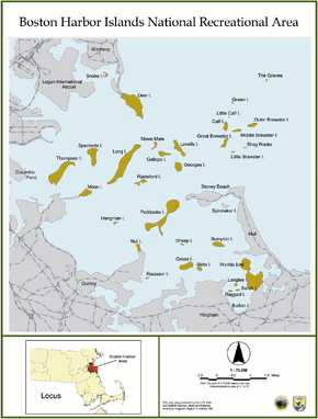
The Boston Harbor Islands National Recreation Area is made up of islands and peninsulas on and around Boston Harbor. These include:[8][9]
- Bumpkin Island (Hingham)
- Button Island (Hingham)
- Calf Island (Boston)
- Deer Island (Boston)
- Gallops Island (Boston)
- Georges Island (Boston)
- Grape Island (Weymouth)
- The Graves (Boston)
- Great Brewster Island (Boston)
- Green Island (Boston)
- Hangman Island (Quincy)
- Langlee Island (Hingham)
- Little Brewster Island (Boston)
- Little Calf Island (Boston)
- Long Island (Boston)
- Lovells Island (Boston)
- Middle Brewster Island (Boston)
- Moon Island (Quincy)
- Nixes Mate (Boston)
- Nut Island (Quincy)
- Outer Brewster Island (Boston)
- Peddocks Island (Hull)
- Raccoon Island (Quincy)
- Ragged Island (Hingham)
- Rainsford Island (Boston)
- Sarah Island (Hingham)
- Shag Rocks (Boston)
- Sheep Island (Weymouth)
- Slate Island (Weymouth)
- Snake Island (Winthrop)
- Spectacle Island (Boston)
- Cathleen Stone Island, formerly known as Thompson Island (Boston)
- Webb Memorial Park (Weymouth)
- World's End (Hingham)
Though they are located in Boston Harbor, neither Castle Island nor Spinnaker Island belong to Boston Harbor Islands National Recreation Area. Other former islands (Apple Island, Governors Island and Noddle's Island) were obliterated by the formation of East Boston and the expansion of Logan International Airport before the creation of the national recreation area.
Management
The Boston Harbor Islands National Recreation Area is managed by the Boston Harbor Islands Partnership,[10] a statutory body established as a federal operating committee by the park enabling legislation. The partnership consists of individual members who represent a range of federal, state, city, and nonprofit agencies, including:
- National Park Service
- U.S. Coast Guard
- Massachusetts Department of Conservation and Recreation
- Massachusetts Port Authority
- Massachusetts Water Resources Authority
- City of Boston
- City of Boston Planning Department
- Boston Harbor Now
- Cathleen Stone Island Outward Bound Education Center
- The Trustees of Reservations
- Boston Harbor Islands Advisory Council[4]
Apart from the representative for the Coast Guard, who is appointed by the Secretary of Homeland Security, all the members of the partnership are appointed by the Secretary of the Interior after consultation with the appropriate agency or other body.[11][12][13]
In practice, day-to-day management of each individual island or other site is the responsibility of one of the partner agencies or other bodies. The partnership provides a consistency and coordination across the whole park.[14]
Access
Boston Harbor City Cruises offers ferry service from Long Wharf to Georges and Spectacle Islands. Ferry service from Hingham to Peddocks Island is also available.[6]
Deer Island, Nut Island, Worlds End, and Webb Memorial are accessible by road from the mainland. Moon Island and Long Island are closed to the public.
See also
- National Register of Historic Places listings in Plymouth County, Massachusetts
- National Register of Historic Places listings in Suffolk County, Massachusetts
References
- ^ "Listing of acreage – December 31, 2011" (XLSX). Land Resource Division, National Park Service. Retrieved December 16, 2012. (National Park Service Acreage Reports)
- ^ "Boston Harbor Islands National Recreation Area". June 27, 2024. Retrieved August 8, 2024.
- ^ "World's End (U.S. National Park Service)". www.nps.gov. Retrieved August 8, 2024.
- ^ a b c "Boston Harbor Islands: A Partnership Park". Boston Harbor Islands. March 19, 2024. Retrieved August 8, 2024.
- ^ "National Historic Landmark nomination for Boston Light". National Park Service. Archived from the original on June 14, 2006. Retrieved June 18, 2006.
- ^ a b "Ferry Schedule". Boston Harbor Islands. Boston Harbor Islands. Archived from the original on July 24, 2024. Retrieved August 8, 2024.
- ^ Riglian, Adam (April 14, 2008). "DiCaprio, Scorsese filming on Peddocks Island". The Patriot Ledger. GateHouse Media. Archived from the original on October 27, 2008. Retrieved May 21, 2008.
- ^ US Geological Survey 7.5 minute series topographic map "Hull" 1971
- ^ "Island Facts". Boston Harbor Islands National Recreation Area. October 30, 2023. Retrieved August 8, 2024.
- ^ "Boston Harbor Islands Partnership - Boston Harbor Islands National Recreation Area (U.S. National Park Service)". www.nps.gov. Retrieved April 4, 2018.
- ^ "Islands Partnership - Governance". Boston Harbor Islands Partnership. Archived from the original on October 5, 2006. Retrieved October 6, 2006.
- ^ "Islands Partnership - Membership". Boston Harbor Islands Partnership. Archived from the original on August 30, 2006. Retrieved October 6, 2006.
- ^ "Public Law 104-33, 110 Stat. 4093 Sec. 1029. Boston Harbor Islands Recreation Area". Retrieved October 6, 2006.
- ^ "Boston Harbor Islands - General Management Plan" (PDF). National Park Service. Retrieved October 19, 2006.
Bibliography
- Best, Neil A., "Preliminary Design of a Recirculating Aquaculture System in Boston Harbor", Masters Thesis, Ocean Engineering, MIT, February 1997. Technical Advisor, Clifford A. Goudey.
- The Boston Globe, "Harboring recreation", Guest Editorial, June 3, 2006.
- Kales, Emily, Kales, David, "All About the Boston Harbor Islands", Hewitts Cove Publishing, 1983.
- Marcus, John, "Scientists Test Once-Polluted Harbor’s Crop Potential", Los Angeles Times, Sunday, January 11, 1998
- Mikal, Alan, "Exploring Boston Harbor", Christopher Publishing House, North Quincy, Massachusetts, 1973. ISBN 978-0-8158-0303-4
- Northeastern Naturalist, Volume 12, Issue sp3, July 2005. Articles on the Boston Harbor Islands. [1]
- Richburg, Julie A., Patterson, William A., III, "Historical Description of the Vegetation of the Boston Harbor Islands, 1600-2000", Northeastern Naturalist, v.12, Special Issue 3, 13-30, 2005.
- Sammarco, Anthony Mitchell, "Boston's Harbor Islands", Images of America series, 1998. ISBN 0-7524-0900-X
- Sherman, Annie, "The Other Islands: The Harbor Islands make for an easy day trip for sunbathers, history buffs—and especially the traffic-weary", Boston magazine, May 2007 issue.
- Snow, Edward Rowe
- "The Islands of Boston Harbor", 1935. ISBN 0-396-08349-8 [2]
- "Sailing Down Boston Bay", Yankee Publishing Company, 1941.
- "Some Events of Boston and Its Neighbors", printed for the State Street Trust Company, Boston, Massachusetts, 1917.
- "The Islands of Boston Harbor", in "Some Events of Boston and Its Neighbors", Chapter 4, printed for the State Street Trust Company, Boston, Massachusetts, 1917.
- Sweetser, M.F., "King's Handbook of Boston Harbor", Moses King Corporation, Boston, 1882; reprinted in 1988 by Applewood Books, and The Friends of Boston Harbor Islands, and in 2010 by BiblioLife. ISBN 978-1-141-97744-4 (2010 reprint). This book was written about the time when the first Boston almshouse was being built on Long Island.
Further reading
Wikimedia Commons has media related to Boston Harbor Islands National Recreation Area.
- Metro (Boston edition) newspaper, "Boston Harbor Islands", Boston Neighborhood section, August 1, 2007, p. 14.
- "Harbor islands are jewels, but lack resources and accessibility", Boston Globe, OP/ED, Sunday, April 4, 2010
External links
 Massachusetts portal

- Boston Harbor Islands National Recreation Area
- Boston Harbor Islands Visitor Guide
- Boston Harbor resources site
- NOAA Soundings Map of Boston Harbor
- Island Alliance (Boston Harbor)
- Boston Harbor Islands - Massachusetts Department of Conservation & Recreation (DCR).
- The Boston Harbor Association resources
 Boston Harbor Islands travel guide from Wikivoyage
- Volunteers and Friends of the Boston Harbor Islands Inc. records, 1770-2011, University Archives and Special Collections, Joseph P. Healey Library, University of Massachusetts Boston
- Sean M. Fisher (2015), Guide to Related Archival Collections Outside of the DCR Archives Pertaining to the Metropolitan Parks System, the Metropolitan Water Works System, and the State Forests and Parks System, Commonwealth of Massachusetts, Department of Conservation and Recreation, OCLC 971134548,
Boston Harbor Islands
- v
- t
- e
- Alewife Brook
- Arborway
- Blue Hills
- Blue Hills Reservation
- Charles River Reservation
- Day Boulevard
- Fellsway
- Fellsway East
- Fellsway West
- Fenway
- Fresh Pond
- Furnace Brook
- Hamond Pond
- Hull Shore Drive
- Jamaicaway
- Lynn Fells
- Lynnway
- Memorial Drive
- Morrissey Boulevard
- Mystic Valley
- Nahant Beach Boulevard
- Nantasket Avenue
- Park Drive
- Quincy Shore Drive
- Revere Beach
- Riverway
- Soldiers Field Road
- Stony Brook
- Storrow Drive
- Truman
- VFW
- West Roxbury
- Winthrop
- Winthrop Shore Drive
- Department of Conservation and Recreation
- Greater Boston
- List of Massachusetts State Parks
| |||||||||||||||||
|---|---|---|---|---|---|---|---|---|---|---|---|---|---|---|---|---|---|
| |||||||||||||||||
| |||||||||||||||||
| |||||||||||||||||
| |||||||||||||||||
| |||||||||||||||||
| |||||||||||||||||
| |||||||||||||||||
| |||||||||||||||||

| |||||||||||||||||
|---|---|---|---|---|---|---|---|---|---|---|---|---|---|---|---|---|---|
| Topics |  | ||||||||||||||||
| Lists by county | |||||||||||||||||
| Lists by city |
| ||||||||||||||||
| Other lists | |||||||||||||||||
| |||||||||||||||||


Authority control databases | |
|---|---|
| International |
|
| National |
|


