National Register of Historic Places listings in Medford, Massachusetts

This is a list of places and properties listed on the National Register of Historic Places in Medford, Massachusetts.
This National Park Service list is complete through NPS recent listings posted June 7, 2024.[1]
Map all coordinates using OpenStreetMap
Download coordinates as:
- KML
- GPX (all coordinates)
- GPX (primary coordinates)
- GPX (secondary coordinates)
Current listings
| [2] | Name on the Register[3] | Image | Date listed[4] | Location | City or town | Description |
|---|---|---|---|---|---|---|
| 1 | Albree-Hall-Lawrence House | 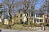 | April 30, 1976 (#76000256) | 353 Lawrence Rd. 42°25′29″N 71°07′12″W / 42.424722°N 71.12°W / 42.424722; -71.12 (Albree-Hall-Lawrence House) | ||
| 2 | John B. Angier House | 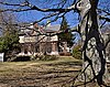 | April 23, 1975 (#75000267) | 129 High St. 42°25′12″N 71°06′54″W / 42.42°N 71.115°W / 42.42; -71.115 (John B. Angier House) | ||
| 3 | Bigelow Block |  | February 24, 1975 (#75000268) | NE Corner of Forest and Salem Sts. 42°25′06″N 71°06′36″W / 42.418333°N 71.11°W / 42.418333; -71.11 (Bigelow Block) | ||
| 4 | Charles Brooks House |  | June 18, 1975 (#75000269) | 309 High St. 42°25′18″N 71°07′28″W / 42.421667°N 71.124444°W / 42.421667; -71.124444 (Charles Brooks House) | ||
| 5 | Jonathan Brooks House | 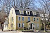 | June 26, 1975 (#75000270) | 2 Woburn St. 42°25′18″N 71°07′26″W / 42.421667°N 71.123889°W / 42.421667; -71.123889 (Jonathan Brooks House) | ||
| 6 | Shepherd Brooks Estate |  | April 21, 1975 (#75000271) | 275 Grove St. 42°26′00″N 71°08′22″W / 42.433333°N 71.139444°W / 42.433333; -71.139444 (Shepherd Brooks Estate) | ||
| 7 | Paul Curtis House |  | May 6, 1975 (#75000272) | 114 South St. 42°25′02″N 71°07′01″W / 42.417222°N 71.116944°W / 42.417222; -71.116944 (Paul Curtis House) | ||
| 8 | Fells Connector Parkways, Metropolitan System of Greater Boston |  | May 9, 2003 (#03000379) | Fellsway East:E. Border Rd. To Fellsway W Fellsway West: Fulton St. to Fellsway E Fellsway:Fellsway E to Wellington Br 42°26′40″N 71°04′45″W / 42.444444°N 71.079167°W / 42.444444; -71.079167 (Fells Connector Parkways, Metropolitan System of Greater Boston) | Extends into Malden. | |
| 9 | George P. Fernald House |  | April 30, 1976 (#76000258) | 12 Rock Hill St. 42°25′14″N 71°07′23″W / 42.420556°N 71.123056°W / 42.420556; -71.123056 (George P. Fernald House) | ||
| 10 | Jonathan Fletcher House | 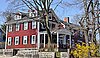 | June 23, 1975 (#75000274) | 283 High St. 42°25′18″N 71°07′23″W / 42.421667°N 71.123056°W / 42.421667; -71.123056 (Jonathan Fletcher House) | ||
| 11 | Grace Episcopal Church |  | November 3, 1972 (#72000139) | 160 High St. 42°25′12″N 71°07′00″W / 42.42°N 71.116667°W / 42.42; -71.116667 (Grace Episcopal Church) | ||
| 12 | Isaac Hall House |  | April 16, 1975 (#75000275) | 43 High St. 42°25′07″N 71°06′41″W / 42.418611°N 71.111389°W / 42.418611; -71.111389 (Isaac Hall House) | ||
| 13 | Hillside Avenue Historic District |  | April 21, 1975 (#75000276) | Property on both sides of Hillside and Grand View Aves. 42°25′13″N 71°06′46″W / 42.420278°N 71.112778°W / 42.420278; -71.112778 (Hillside Avenue Historic District) | ||
| 14 | Lawrence Light Guard Armory | 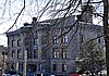 | March 10, 1975 (#75000277) | 90 High St. 42°25′07″N 71°06′47″W / 42.418611°N 71.113056°W / 42.418611; -71.113056 (Lawrence Light Guard Armory) | ||
| 15 | Joseph K. Manning House | 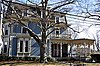 | April 7, 1989 (#88000712) | 35–37 Forest St. 42°25′11″N 71°06′37″W / 42.419722°N 71.110278°W / 42.419722; -71.110278 (Joseph K. Manning House) | ||
| 16 | John H. McGill House |  | April 9, 1980 (#80000640) | 56 Vernon St. 42°25′28″N 71°07′41″W / 42.424444°N 71.128056°W / 42.424444; -71.128056 (John H. McGill House) | ||
| 17 | Medford Pipe Bridge |  | January 18, 1990 (#89002253) | Over the Mystic River, between S. Court St. and Mystic Valley Parkway. 42°25′06″N 71°06′44″W / 42.418333°N 71.112222°W / 42.418333; -71.112222 (Medford Pipe Bridge) | ||
| 18 | Middlesex Canal Historic and Archeological District | 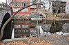 | November 19, 2009 (#09000936) | Numerous locations along the historic route of the Middlesex Canal 42°25′03″N 71°07′50″W / 42.4175°N 71.1306°W / 42.4175; -71.1306 (Middlesex Canal Historic and Archeological District) | Extends into other Middlesex County communities and Boston in Suffolk County. | |
| 19 | Middlesex Fells Reservation Parkways | 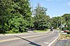 | February 4, 2003 (#02001749) | E Border Rd., Fellsway E, Fellsway W, Hillcrest Pky., South St., Pond St., S Border Rd., Ravine Rd., and Woodland Rd. 42°26′43″N 71°06′10″W / 42.445278°N 71.102778°W / 42.445278; -71.102778 (Middlesex Fells Reservation Parkways) | Included roadways are in Medford, Stoneham, and Winchester. | |
| 20 | Middlesex Fells Reservoirs Historic District |  | January 18, 1990 (#89002249) | Roughly bounded by Pond St., Woodland Rd., I-93, and MA 28 42°27′18″N 71°05′43″W / 42.455°N 71.095278°W / 42.455; -71.095278 (Middlesex Fells Reservoirs Historic District) | Extends into Stoneham. | |
| 21 | Mystic Dam |  | January 18, 1990 (#89002282) | Between Lower and Upper Mystic Lakes 42°25′50″N 71°08′56″W / 42.430556°N 71.148889°W / 42.430556; -71.148889 (Mystic Dam) | Extends between Medford and Arlington; incorrectly listed as being in Winchester | |
| 22 | Mystic Gatehouse | 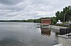 | January 18, 1990 (#89002284) | East of Edgewater Pl. on the southeastern end of Upper Mystic Lake 42°25′52″N 71°08′52″W / 42.431111°N 71.147778°W / 42.431111; -71.147778 (Mystic Gatehouse) | Incorrectly listed as being in Winchester. | |
| 23 | Mystic Valley Parkway, Metropolitan Park System of Greater Boston MPS |  | January 18, 2006 (#05001529) | Mystic Valley Parkway 42°25′47″N 71°07′49″W / 42.429722°N 71.130278°W / 42.429722; -71.130278 (Mystic Valley Parkway, Metropolitan Park System of Greater Boston MPS) | Runs through Arlington, Medford, Somerville, and Winchester. | |
| 24 | Edward Oakes House |  | April 9, 1980 (#80000639) | 5 Sylvia Rd. 42°24′43″N 71°06′39″W / 42.411944°N 71.110833°W / 42.411944; -71.110833 (Edward Oakes House) | ||
| 25 | Old Medford High School |  | October 6, 1983 (#83004068) | 22-24 Forest St. 42°25′15″N 71°06′32″W / 42.420833°N 71.108889°W / 42.420833; -71.108889 (Old Medford High School) | Now houses condominiums and a community theater. | |
| 26 | Old Ship Street Historic District | 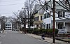 | April 14, 1975 (#75000279) | Both sides of Pleasant St. from Riverside Ave. to Park St. 42°24′59″N 71°06′06″W / 42.416389°N 71.101667°W / 42.416389; -71.101667 (Old Ship Street Historic District) | ||
| 27 | Park Street Railroad Station |  | April 21, 1975 (#75000280) | 20 Magoun Ave. 42°24′59″N 71°05′55″W / 42.416389°N 71.098611°W / 42.416389; -71.098611 (Park Street Railroad Station) | Now houses a community service organization. | |
| 28 | Richard Pinkham House |  | January 16, 2008 (#07001399) | 24 Brooks Park 42°24′43″N 71°06′35″W / 42.411944°N 71.109722°W / 42.411944; -71.109722 (Richard Pinkham House) | ||
| 29 | Revere Beach Parkway-Metropolitan Park System of Greater Boston |  | December 6, 2007 (#07001241) | Revere Beach Pkwy 42°24′16″N 71°01′49″W / 42.404386°N 71.030361°W / 42.404386; -71.030361 (Revere Beach Parkway-Metropolitan Park System of Greater Boston) | Extends into Everett and Chelsea | |
| 30 | Isaac Royall House | 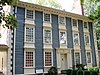 | October 15, 1966 (#66000786) | 15 George St. 42°24′43″N 71°06′44″W / 42.411944°N 71.112222°W / 42.411944; -71.112222 (Isaac Royall House) | ||
| 31 | Salem Street Burying Ground | 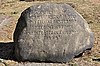 | August 27, 1981 (#81000115) | Medford Sq. 42°25′05″N 71°06′27″W / 42.418172°N 71.107614°W / 42.418172; -71.107614 (Salem Street Burying Ground) | ||
| 32 | Peter Tufts House | 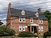 | November 24, 1968 (#68000044) | 350 Riverside Ave. 42°24′40″N 71°05′39″W / 42.411111°N 71.094167°W / 42.411111; -71.094167 (Peter Tufts House) | ||
| 33 | Unitarian Universalist Church and Parsonage |  | April 21, 1975 (#75000281) | 141 and 147 High St. 42°25′13″N 71°06′55″W / 42.420278°N 71.115278°W / 42.420278; -71.115278 (Unitarian Universalist Church and Parsonage) | ||
| 34 | US Post Office-Medford Main |  | June 18, 1986 (#86001346) | 20 Forest St. 42°25′08″N 71°06′36″W / 42.418889°N 71.11°W / 42.418889; -71.11 (US Post Office-Medford Main) | ||
| 35 | John Wade House |  | June 18, 1975 (#75000282) | 253 High St. 42°25′15″N 71°07′18″W / 42.420833°N 71.121667°W / 42.420833; -71.121667 (John Wade House) | ||
| 36 | Jonathan Wade House | 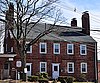 | April 21, 1975 (#75000283) | 13 Bradlee Rd. 42°25′08″N 71°06′39″W / 42.418889°N 71.110833°W / 42.418889; -71.110833 (Jonathan Wade House) |
References
Wikimedia Commons has media related to National Register of Historic Places in Medford, Massachusetts.
- ^ National Park Service, United States Department of the Interior, "National Register of Historic Places: Weekly List Actions", retrieved June 7, 2024.
- ^ Numbers represent an alphabetical ordering by significant words. Various colorings, defined here, differentiate National Historic Landmarks and historic districts from other NRHP buildings, structures, sites or objects.
- ^ "National Register Information System". National Register of Historic Places. National Park Service. April 24, 2008.
- ^ The eight-digit number below each date is the number assigned to each location in the National Register Information System database, which can be viewed by clicking the number.
- v
- t
- e

| Barnstable County | |
|---|---|
| Bristol County | |
| Essex County | |
| Hampden County | |
| Middlesex County | |
| Norfolk County | |
| Suffolk County | |
| Worcester County |
 Category
 National Register of Historic Places portal
 United States portal


