Lea Newbold
| Lea Newbold | |
| Före detta civil parish | |
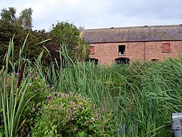 Lea Hall Farm | |
| Land |  Storbritannien Storbritannien |
|---|---|
| Riksdel | England |
| Enhetskommun | Cheshire West and Chester |
| Ceremoniellt grevskap | Cheshire |
| Civil parish | Aldford and Saighton |
| Koordinater | 53°07′42″N 2°50′45″V / 53.12826°N 2.84578°V / 53.12826; -2.84578 |
| Folkmängd | 8 (2001) |
| Tidszon | UTC (UTC+0) |
| - sommartid | BST (UTC+1) |
| Geonames | 7294603 |
  Läge i Storbritannien | |
Lea Newbold var en civil parish 1866–2015[1] när det uppgick den en del av den då nybildade Aldford and Saighton,[2] i distriktet Cheshire West and Chester, i Storbritannien.[3] Den låg i grevskapet Cheshire och riksdelen England, i den södra delen av landet, 260 km nordväst om huvudstaden London. Civil parish hade 8 invånare år 2001.[4] Byn nämndes i Domedagsboken (Domesday Book) år 1086, och kallades då Lai.[5]
Källor
- ^ ”Relationships and changes Lea Newbold Tn/CP through time”. A Vision of Britain through Time. https://visionofbritain.org.uk/unit/10090441. Läst 30 augusti 2023.
- ^ ”Cheshire West and Chester Registration District”. UKBMD. https://www.ukbmd.org.uk/reg/districts/cheshire%20west%20and%20chester.html. Läst 30 augusti 2023.
- ^ Lea Newbold hos Geonames.org (cc-by); post uppdaterad 2010-10-17; databasdump nerladdad 2016-05-06
- ^ ”Lea Newbold”. GENUKI. https://www.genuki.org.uk/big/eng/CHS/Leanewbold. Läst 30 augusti 2023.
- ^ ”Cheshire L-Z”. The Domesday Book Online. https://www.domesdaybook.co.uk/cheshire2.html#leanewbold. Läst 30 augusti 2023.
Externa länkar
 Wikimedia Commons har media som rör Lea Newbold.Bilder & media


