Appleton (Ohio)
| Appleton | |||
|---|---|---|---|
| Land |  USA USA | ||
| Delstat |  Ohio Ohio | ||
| Fylke | Licking County | ||
| Status | kommunefritt område (unincorporated community) | ||
| Grunnlagt | 1832 | ||
 Appleton 40°12′33″N 82°36′59″V | |||
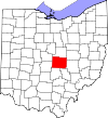
Appleton er et kommunefritt område (unincorporated community) i Licking County, i delstaten Ohio i USA.[1]
Historie
Appleton ble opprettet i 1832.[2] Et postkontor ble etablert i Appleton i 1836 og var i drift til 1904.[3]
Referanser
- ^ «Appleton». Geographic Names Information System, U.S. Geological Survey.
- ^ Brister, Edwin M. P. (1909). Centennial History of the City of Newark and Licking County, Ohio. S.J. Clarke Publishing Company. s. 249.
- ^ «Licking County». Jim Forte Postal History. Besøkt 6. desember 2015.
- v
- d
- r
Den politiske og geografiske oppdelingen av Licking County, Ohio
Fylkeshovedstad: Newark
Heath • New Albany‡ • Newark • Pataskala • Reynoldsburg‡
Alexandria • Buckeye Lake‡ • Granville • Gratiot‡ • Hanover • Hartford • Hebron • Johnstown • Kirkersville • St. Louisville • Utica‡
Bennington • Bowling Green • Burlington • Eden • Etna • Fallsbury • Franklin • Granville • Hanover • Harrison • Hartford • Hopewell • Jersey • Liberty • Licking • Madison • Mary Ann • McKean • Monroe • Newark • Newton • Perry • St. Albans • Union • Washington
place
Beechwood Trails • Brownsville • Etna • Granville South • Harbor Hills • Marne
områder
Amsterdam • Appleton • Ben • Boston • Chatham • Columbia Center • Fleatown • Fredonia • Homer • Jacksontown • Jersey • Linnville • Lloyd Corners • Lock‡ • Locust Grove • Luray • New Way • Outville • Perryton • Rain Rock • Rocky Fork • Toboso • Union Station • Vanatta • Wagram • Welsh Hills • Wilkins Run
Belfast • Central City • Claylick • Denmans Crossroads • Exeter • Livingston • Lockport • Long Run • Moscow • Mount Hope • New Winchester • Oberlin • Raccoon Town
‡Dette befolkede stedet har også areal i tilstøtende fylke(r)
Portal: USA


