Yvrac-et-Malleyrand
Gemeente in Frankrijk  | |||
|---|---|---|---|
  | |||
| Situering | |||
| Regio | Nouvelle-Aquitaine | ||
| Departement | Charente (16) | ||
| Arrondissement | Angoulême | ||
| Kanton | Val de Tardoire | ||
| Coördinaten | 45° 45′ NB, 0° 27′ OL | ||
| Algemeen | |||
| Oppervlakte | 18,9 km² | ||
| Inwoners (1 januari 2021) | 564 (30 inw./km²) | ||
| Hoogte | 109 - 315 m | ||
| Overig | |||
| Postcode | 16110 | ||
| INSEE-code | 16425 | ||
| Website | Officiële website | ||
| Detailkaart | |||
 | |||
| Foto's | |||
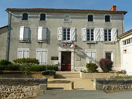 | |||
| Gemeentehuis | |||
| |||

Yvrac-et-Malleyrand is een gemeente in het Franse departement Charente (regio Nouvelle-Aquitaine) en telt 530 inwoners (2008). De plaats maakt deel uit van het arrondissement Angoulême.
Geografie
De oppervlakte van Yvrac-et-Malleyrand bedraagt 18,8 km², de bevolkingsdichtheid is 24,7 inwoners per km².
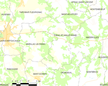
De onderstaande kaart toont de ligging van Yvrac-et-Malleyrand met de belangrijkste infrastructuur en aangrenzende gemeenten.
 |
Demografie
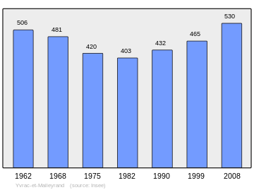
Onderstaande figuur toont het verloop van het inwonertal (bron: INSEE-tellingen).
Externe links
- (fr) Statistische informatie op de website van INSEE
Mediabestanden
Zie de categorie Yvrac-et-Malleyrand van Wikimedia Commons voor mediabestanden over dit onderwerp.


