Nardodipace
Gemeente in Italië  | |||
|---|---|---|---|
  | |||
| Situering | |||
| Regio | Calabrië (CAL) | ||
| Provincie | Vibo Valentia (VV) | ||
| Coördinaten | 38° 28′ NB, 16° 20′ OL | ||
| Algemeen | |||
| Oppervlakte | 32,7 km² | ||
| Inwoners (1 januari 2023) | 1.087 (46 inw./km²) | ||
| Overig | |||
| Postcode | 88020 | ||
| Netnummer | 0963 | ||
| Beschermheilige | Maria | ||
| ISTAT-code | 102024 | ||
| Website | http://www.comune.nardodipace.vv.it/ | ||
| Detailkaart | |||
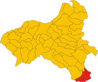 | |||
| Locatie van Nardodipace in Vibo Valentia (VV) | |||
| |||

Nardodipace is een gemeente in de Italiaanse provincie Vibo Valentia (regio Calabrië) en telt 1437 inwoners (31-12-2004). De oppervlakte bedraagt 32,7 km², de bevolkingsdichtheid is 46 inwoners per km².
-
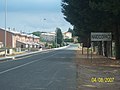 Nardodipace
 -
 Plein in Nardodipace
 -
 Gemeentehuis


Demografie
Nardodipace telt ongeveer 521 huishoudens. Het aantal inwoners daalde in de periode 1991-2001 met 8,3% volgens cijfers uit de tienjaarlijkse volkstellingen van ISTAT.
| Jaar | Inwoneraantal |
|---|---|
| 1991 | 1610 |
| 2001 | 1477 |
Geografie
Nardodipace grenst aan de volgende gemeenten: Caulonia (RC), Fabrizia, Martone (RC), Mongiana, Pazzano (RC), Roccella Ionica (RC), Stilo (RC).
Bronnen, noten en/of referenties
- Italiaans bureau voor statistiek
Gemeenten in de provincie Vibo Valentia
Acquaro · Arena · Briatico · Brognaturo · Capistrano · Cessaniti · Dasà · Dinami · Drapia · Fabrizia · Filadelfia · Filandari · Filogaso · Francavilla Angitola · Francica · Gerocarne · Jonadi · Joppolo · Limbadi · Maierato · Mileto · Mongiana · Monterosso Calabro · Nardodipace · Nicotera · Parghelia · Pizzo · Pizzoni · Polia · Ricadi · Rombiolo · San Calogero · San Costantino Calabro · San Gregorio d'Ippona · San Nicola da Crissa · Sant'Onofrio · Serra San Bruno · Simbario · Sorianello · Soriano Calabro · Spadola · Spilinga · Stefanaconi · Tropea · Vallelonga · Vazzano · Vibo Valentia · Zaccanopoli · Zambrone · Zungri
Mediabestanden
Zie de categorie Nardodipace van Wikimedia Commons voor mediabestanden over dit onderwerp.


