Fenland (district)
Niet-metropolitaans district in Engeland  | |||
|---|---|---|---|
 (Details) | |||
  | |||
| Situering | |||
| Land | Engeland | ||
| County | Cambridgeshire | ||
| Regio | East of England | ||
| Coördinaten | 52°34'30"NB, 0°2'56"OL | ||
| Algemeen | |||
| Oppervlakte | 546,4502[1] km² | ||
| Inwoners (2018[2]) | 101.491 (186 inw./km²) | ||
| ONS-code | E07000010 | ||
| Website | Officiële website | ||
| Detailkaart | |||
 | |||
| |||

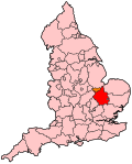
Fenland is een Engels district in het shire-graafschap (non-metropolitan county OF county) Cambridgeshire. Het bestuurlijke centrum is de plaats March. Fenland heeft een oppervlakte van 546 km² en telt 101.000 inwoners.
Het district ligt in het vlakke, moerasachtige en agrarische gebied The Fens, waarnaar het ook vernoemd is.
Van de bevolking is 19,1% ouder dan 65 jaar. De werkloosheid bedraagt 2,7% van de beroepsbevolking (cijfers volkstelling 2001).
Civil parishes in district Fenland
Benwick, Chatteris, Christchurch, Doddington, Elm, Gorefield, Leverington, Manea, March, Newton, Parson Drove, Tydd St. Giles, Whittlesey, Wimblington, Wisbech, Wisbech St. Mary.
Bronnen, noten en/of referenties
- ↑ Office for National Statistics → Download → SAM_for_Administrative_Areas_(2018).zip → SAM_LAD_DEC_2018_UK.xlsx. Gearchiveerd op 12 juni 2023.
- ↑ https://www.ons.gov.uk/file?uri=/peoplepopulationandcommunity/populationandmigration/populationestimates/datasets/populationestimatesforukenglandandwalesscotlandandnorthernireland/mid20182019laboundaries/ukmidyearestimates20182019ladcodes.xls Schatting Office for National Statistics: knop MYE5 → kolom Estimated Population mid-2018]
- Volkstelling 2001, Office for National Statistics


