アンジョー県
アンジョー県 | |
|---|---|
  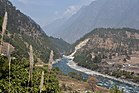 ロヒット川とキビトゥ | |
 アルナーチャル・プラデーシュ州内の位置 | |
| 国 |  インド インド |
| 州 | アルナーチャル・プラデーシュ州 |
| 県都 | ハワイ |
| 政府 | |
| • ローク・サバー | アルナーチャル・イースト |
| • アルナーチャル・プラデーシュ州議会 | ハユリアン |
| 面積 | |
| • Total | 6,190 km2 |
| 人口 (2011) | |
| • Total | 21,167人 |
| • 密度 | 3.4人/km2 |
| 人口統計 | |
| • 識字率(英語版) | 59.4% |
| • 性比(男性千人あたり女性数) | 805 |
| 等時帯 | UTC+05:30 (IST) |
| ウェブサイト | anjaw |
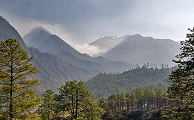
座標: 北緯27度55分30秒 東経96度20分53秒 / 北緯27.92500度 東経96.34806度 / 27.92500; 96.34806 アンジョー県(アンジョーけん、英語: Anjaw District、/ˈændʒɔ:/)は、インド北東部アルナーチャル・プラデーシュ州の県。2004年に、アルナーチャル・プラデーシュ州の県域再編修正法 (the Arunachal Pradesh Re-organization of Districts Amendment Act) により、ロヒット県(英語版)から分離する形で、県として新設された[1]。この県は、北側を中国と接している。 標高1296mにあるハワイは県都であり、ブラマプトラ川の支流であるロヒット川(英語版)の河岸に位置している。この県は、インドで最も東に位置している[2] 中国との国境にさらに近い集落には、ドン(英語版)[3]、ワロン(英語版)、キビトゥ(英語版)、カホ(英語版)がある。
歴史
1962年の中印国境紛争の際には、アンジョー県の一部が中国によって占領された[4]。国境紛争地域であるため、アンジョー県にはインド軍が常駐している。2020年中印国境紛争の際には、追加の部隊がこの地域に派遣された[5]。
地理
河川
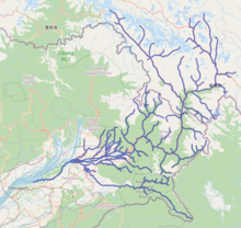
おもな河川は以下の通りである[2]。
- ロヒット川 (Lohit River) - 地元のミシュミ人はタル (Talu) と呼ぶ。
- Lam River
- Tidding River
- Delei River
- Krowti River
- Dichu River
- Lati River
- Klung River
- Dav River
- Telua River
- Ampani River
- Sarti River
- Yepak river
交通
2,000-キロメートル (1,200 mi)におよぶ、マゴ (Mago)=ティンブ(英語版)とビジャイナガル(英語版)をマクマホンラインに沿って結ぶ、アルナーチャル・フロンティア・ハイウェイ(英語版)が構想されており[6][7][8][9]、さらに構想中の東西産業回廊ハイウェイ(英語版)と交差し、この県を縦貫すること担っているが、その地図は、 こちらやこちら[10]にある。
経済
農業
おもな農産物は、トウモロコシ、雑穀、米、豆、カルダモン、オレンジ、ナシ、プラム、リンゴである[11]。
行政区分
アルナーチャル・プラデーシュ州議会(英語版)の選挙区はハユリアン選挙区(英語版)だけがある。この選挙区は、ローク・サバー(連邦議会下院)のアルナーチャル・イースト選挙区(英語版)の一部になっている[12]。
この県には、「サークル (circle)」と称される郡が8つある。
- Hayuliang
- Metengliang
- Goiliang
- Chaglagam
- Manchal
- ハワイ郡 (Hawai)
- Walong
- Kibithoo

人口
2011年(英語版)の国勢調査(英語版)によれば、アンジョー県の人口(英語版)は 21,167人であり、おおよそパラオの人口と同じである[13]。これは、640あるインドの県の中で、639番目にあたる。人口密度は、3人毎平方キロメートル (7.8/sq mi) である。2001年から2011年にかけての人口増加率は、13.77% であった。アンジョー県の性比は、男性1,000人に対して女性805人であり、識字率は 59.4% である[要出典]
部族
ミシュミ人(英語版)と、 ザクリン人(英語版)[14](かつては「メヨル (Meyor)」と称されていた)が、この県の主要な部族となっている。
2011年の国勢調査によれば、部族人口は合わせて 16,451人 (77.72%) を占め、そのおもな部族は、 Idu/Taraon Mishmi (9,991人)、Kaman/Miju Mishmi (5,021人)、Degaru Mishmi (472人)、Meyor (472人) であった。
言語
宗教
植物相、動物相
この件は、野生生物が豊かである。希少な哺乳動物としては、ミジュ諸語(英語版)で 「gheyam」と称されるミシュミタキン(英語版)、アカゴーラル(英語版)、ゴンシャンホエジカ(英語版)、ブタオホエジカ(英語版)などがおり、鳥類の希少種ではミジュ諸語で「mankree」と称されるオジロニジキジがいる。松の一種で、ミジュ諸語で「Rok Sak」というメルクシマツ(英語版)は、インド北東部の中でもアンジョー県にしか自生していない[17]。近年、科学的に関心が寄せられてるモモンガも、この件には生息している。当地のものは「Mishmi giant flying squirrel」と称され、「Petaurista mishmiensis」と学名が命名されている[18]。近年、科学者たちが新たに発見したのはホオジロマカク(英語版)である。これは、2015年に中国で発見されていたが、インドに生息していることが確認されたのは最近のことである。この発見によって、インドに生息する哺乳類の総数は 438種となった。
金融
アンジョー県に店舗を構える銀行の一覧。
- インドステイト銀行、ハワイ[19]
- インドステイト銀行、ハユリアン[20]
脚注
- ^ Law, Gwillim (25 September 2011). “Districts of India”. Statoids. 2011年10月11日閲覧。
- ^ a b “Anjaw District”. 14 November 2006時点のオリジナルよりアーカイブ。2006年10月27日閲覧。
- ^ Gokhale, Nitin A. (20 August 2001). “Dong”. Outlook India. http://www.outlookindia.com/article.aspx?212945 2012年12月16日閲覧。.
- ^ Sharma, Shantanu Nandan (22 June 2020). “What's it like to live in villages along the India-China border?”. The Economic Times. https://economictimes.indiatimes.com/news/politics-and-nation/whats-it-like-to-live-in-villages-along-the-india-china-frontier/articleshow/76486005.cms 2020年9月3日閲覧。
- ^ “India secures its east after western Himalayan clashes with China” (英語). Hindustan Times (2020年9月2日). 2020年9月3日閲覧。
- ^ “Top officials to meet to expedite road building along China border”. Dipak Kumar Dash. timesofindia.indiatimes.com. 27 October 2014閲覧。
- ^ “Narendra Modi government to provide funds for restoration of damaged highways”. Daily News and Analysis (20 September 2014). 27 October 2014閲覧。
- ^ “Indian Government Plans Highway Along Disputed China Border”. Ankit Panda. thediplomat.com. 27 October 2014閲覧。
- ^ “Govt planning road along McMohan line in Arunachal Pradesh: Kiren Rijiju”. Live Mint (14 October 2014). 2014年10月26日閲覧。
- ^ “China warns India against paving road in Arunachal”. Ajay Banerjee. tribuneindia.com. 2014年10月26日閲覧。
- ^ “Anjaw”. indiangos.com. 12 March 2007時点のオリジナルよりアーカイブ。2006年10月27日閲覧。
- ^ “Assembly Constituencies allocation w.r.t District and Parliamentary Constituencies”. Chief Electoral Officer, Arunachal Pradesh website. 13 August 2011時点のオリジナルよりアーカイブ。21 March 2011閲覧。
- ^ US Directorate of Intelligence. “Country Comparison:Population”. 2007年6月13日時点のオリジナルよりアーカイブ。2011年10月1日閲覧。 “Palau 20,956 July 2011 est.”
- ^ “Zakhring”. Ethnologue.com. 11 November 2006時点のオリジナルよりアーカイブ。2006年10月27日閲覧。
- ^ “Census of India Website : Office of the Registrar General & Census Commissioner, India”. www.censusindia.gov.in. 2022年3月31日時点のオリジナルよりアーカイブ。2023年12月4日閲覧。
- ^ “Anjaw District Religion Data - Hindu/Muslim”. Population Census Data. 2023年12月5日閲覧。
- ^ Choudhury, Anwaruddin (2008) Survey of mammals and birds in Dihang-Dibang biosphere reserve, Arunachal Pradesh. Final report to Ministry of Environment & Forests, Government of India. The Rhino Foundation for nature in NE India, Guwahati, India. 70pp.
- ^ Choudhury, Anwaruddin (2009). One more new flying squirrel of the genus Petaurista Link, 1795 from Arunachal Pradesh in north-east India. The Newsletter and Journal of the RhinoFoundation for nat. in NE India 8: 26–34, plates.
- ^ “State Bank of India Hawai, Branch Details”. 2023年12月4日閲覧。
- ^ “State Bank of India, Hayuliang Branch Details”. 2023年12月4日閲覧。
外部リンク
ウィキメディア・コモンズには、アンジョー県に関連するカテゴリがあります。
- Official website
 | 中国 | | ||
| ロヒット県(英語版) |  | ミャンマー | ||
 アンジョー県 アンジョー県 | ||||
 | ||||
| チャンラン県(英語版) |
典拠管理データベース | |
|---|---|
| 全般 |
|
| 国立図書館 |
|


