Southampton (New York)
| Southampton city | |
|---|---|
| (EN) Southampton, New York | |
  | |
 | |
| Localizzazione | |
| Stato |  Stati Uniti Stati Uniti |
| Stato federato |  New York New York |
| Contea | Suffolk |
| Amministrazione | |
| Sindaco | Anna Throne-Holst (D) |
| Territorio | |
| Coordinate | 40°53′07″N 72°23′43″W40°53′07″N, 72°23′43″W (Southampton) |
| Altitudine | 8 e 13 m s.l.m. |
| Superficie | 765,6 km² |
| Abitanti | 56 790 (2010) |
| Densità | 74,18 ab./km² |
| Altre informazioni | |
| Cod. postale | 11968–11969 e 11968 |
| Prefisso | 631 |
| Fuso orario | UTC-5 |
| Cartografia | |
  Southampton | |
 | |
| Sito istituzionale | |
| Modifica dati su Wikidata · Manuale | |
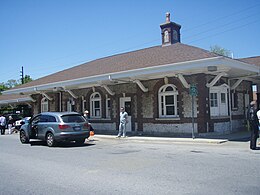
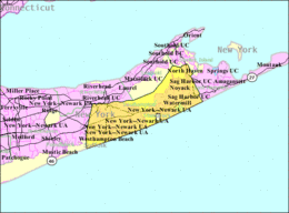
Southampton è un comune (city) degli Stati Uniti d'America della contea di Suffolk nello Stato di New York. La popolazione era di 56 790 persone al censimento del 2010. Fa parte dell'area metropolitana di New York. Situata nella parte orientale dell'isola di Long Island, Southampton occupa un settore che affaccia sull'oceano Atlantico, posto nella penisola di South Fork.
Geografia fisica
Secondo lo United States Census Bureau, ha un'area totale di 295,6 miglia quadrate (765,6 km²).
Storia
La città è stata fondata quando dei coloni provenienti da Lynn, Massachusetts, ottennero dei terreni locali da parte della tribù dei Shinnecock nel 1640. I primi coloni erano otto uomini, una donna, e un ragazzo che lavorava nelle terre di Conscience Point. Questi uomini erano Thomas Halsey, Edward Howell, Edmond Farrington, Edmund Needham, Abraham Pierson the Elder, Thomas Sayre, Josiah Stanborough, George Welbe, Henry Walton e Job Sayre. Il 7 luglio 1640 furono determinati i confini della città. Nel corso dei successivi anni (1640-1643) la popolazione di Southampton aumentò grazie all'arrivo di 43 famiglie.
Società
Evoluzione demografica
Secondo il censimento[1] del 2000, c'erano 54 712 persone.
Etnie e minoranze straniere
Secondo il censimento del 2000, la composizione etnica della città era formata dall'87,98% di bianchi, il 6,62% di afroamericani, lo 0,41% di nativi americani, lo 0,89% di asiatici, lo 0,08% di oceanici, il 2,28% di altre razze, e l'1,73% di due o più etnie.
Note
- ^ American FactFinder, su factfinder2.census.gov, United States Census Bureau. URL consultato il 20 dicembre 2016.
Altri progetti
Altri progetti
- Wikimedia Commons
 Wikimedia Commons contiene immagini o altri file su Southampton
Collegamenti esterni
- (EN) Sito ufficiale, su southamptontownny.gov.
- (EN) Southampton, in City-data.com, Advameg Inc.
V · D · M | |
|---|---|
| Town | Babylon · Brookhaven · East Hampton · Huntington · Islip · Riverhead (capoluogo) · Shelter Island · Smithtown · Southampton · Southold |
| Villaggi | Amityville · Asharoken · Babylon · Belle Terre · Bellport · Brightwaters · Dering Harbor · East Hampton · Greenport · Head of the Harbor · Huntington Bay · Islandia · Lake Grove · Lindenhurst · Lloyd Harbor · Mastic Beach · Nissequogue · North Haven · Northport · Ocean Beach · Old Field · Patchogue · Poquott · Port Jefferson · Quogue · Sag Harbor · Sagaponack · Saltaire · Shoreham · Southampton · Village of the Branch · Westhampton Beach · West Hampton Dunes |
| CDP | Amagansett · Aquebogue · Baiting Hollow · Bay Shore · Bayport · Baywood · Blue Point · Bohemia · Brentwood · Bridgehampton · Brookhaven · Calverton · Center Moriches · Centereach · Centerport · Central Islip · Cold Spring Harbor · Commack · Copiague · Coram · Cutchogue · Deer Park · Dix Hills · East Farmingdale · East Hampton North · East Islip · East Marion · East Moriches · East Northport · East Patchogue · East Quogue · East Shoreham · Eastport · Eatons Neck · Elwood · Farmingville · Fire Island · Fishers Island · Flanders · Fort Salonga · Gilgo · Gordon Heights · Great River · Greenlawn · Greenport West · Halesite · Hampton Bays · Hauppauge · Holbrook · Holtsville · Huntington · Huntington Station · Islip · Islip Terrace · Jamesport · Kings Park · Lake Ronkonkoma · Laurel · Manorville · Mastic · Mattituck · Medford · Melville · Middle Island · Miller Place · Montauk · Moriches · Mount Sinai · Napeague · Nesconset · New Suffolk · North Amityville · North Babylon · North Bay Shore · North Bellport · North Great River · North Lindenhurst · North Patchogue · North Sea · Northampton · Northville · Northwest Harbor · Noyack · Oak Beach-Captree · Oakdale · Orient · Peconic · Port Jefferson Station · Quiogue · Remsenburg-Speonk · Ridge · Riverhead · Riverside · Rocky Point · Ronkonkoma · Sayville · Selden · Setauket-East Setauket · Shelter Island · Shelter Island Heights · Shinnecock Hills · Shirley · Smithtown · Sound Beach · South Huntingto · Southold · Springs · St. James · Stony Brook · Stony Brook University · Terryville · Tuckahoe · Wading River · Wainscott · Water Mill · West Babylon · West Bay Shore · West Hills · West Islip · West Sayville · Westhampton · Wheatley Heights · Wyandanch · Yaphank |
| Altre comunità | Canaan Lake · Cherry Grove · Crystal Brook · Cupsogue Beach · Davis Park · Fire Island Pines · Hagerman · Ocean Bay Park · Point O' Woods · Remsenburg · South Haven · Speonk · Strongs Neck · Upton · Water Island · West Manor |
| Riserve indiane | Poospatuck · Shinnecock |
| Controllo di autorità | VIAF (EN) 31145376591983720491 · ISNI (EN) 0000 0004 0370 9808 · LCCN (EN) n83226247 · J9U (EN, HE) 987007566902305171 |
|---|
 Portale Stati Uniti d'America: accedi alle voci di Wikipedia che parlano degli Stati Uniti d'America


