Reichmannsdorf

Cet article est une ébauche concernant une localité allemande.
Vous pouvez partager vos connaissances en l’améliorant (comment ?) selon les recommandations des projets correspondants.
Reichmannsdorf


| Pays |  Allemagne Allemagne |
|---|---|
| Land | Thuringe |
| Rural district of Thuringia | arrondissement de Saalfeld-Rudolstadt |
| Commune urbaine | Saalfeld |
| Superficie | 19,99 km2 () |
| Altitude | 710 m |
| Coordonnées | 50° 32′ 00″ N, 11° 13′ 00″ E |
| Population | 767 hab. () |
|---|---|
| Densité | 38,4 hab./km2 () |
| Statut | Commune en Allemagne (jusqu'au ), Ortsteil (depuis le ) |
|---|
| Code postal | 98739 |
|---|---|
| Indicatif téléphonique | 036701 |
| Immatriculation | SLF |
| Site web | (de) www.vg-lpsr.de |

modifier - modifier le code - modifier Wikidata
Reichmannsdorf est une municipalité allemande du land de Thuringe, dans l’arrondissement de Saalfeld-Rudolstadt, au centre de l’Allemagne. En 2015, sa population est de 755 habitants.
Histoire

Cette section est vide, insuffisamment détaillée ou incomplète. Votre aide est la bienvenue ! Comment faire ?
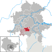
Géographie

Localisation du village.
Notes et références
Cette section est vide, insuffisamment détaillée ou incomplète. Votre aide est la bienvenue ! Comment faire ?
Liens externes
- Notices d'autorité
 :
: - VIAF
- GND
Source de la traduction
- (de) Cet article est partiellement ou en totalité issu de l’article de Wikipédia en allemand intitulé « Reichmannsdorf » (voir la liste des auteurs).
 Portail de la Thuringe


