Windmill Hill Historic District
Historic district in Rhode Island, United States
United States historic place
Windmill Hill Historic District | |
 | |
41°31′35″N 71°22′59″W / 41.52639°N 71.38306°W / 41.52639; -71.38306 | |
| Architectural style | Mid 19th Century Revival, Late Victorian |
|---|---|
| NRHP reference No. | 78000067 [1] |
| Added to NRHP | October 2, 1978 |
The Windmill Hill Historic District is a historic district encompassing a large rural landscape in Jamestown, Rhode Island. It is bounded on the north by Eldred Avenue, on the east by East Shore Road, on the south by Great Creek, and on the west by Narragansett Bay. The area's historical resources included six farmsteads, as well as the Quaker Meetinghouse, the Jamestown Windmill, and its associated miller's house and barn. The area is predominantly rolling hills with open pastureland and forest.[2] The district was listed on the National Register of Historic Places in 1978.[1] The area is also rich in prehistoric evidence of Native American occupation, which is the subject of the Jamestown Archeological District listing on the National Register.[2]
-
 Friends Meeting House with Jamestown Windmill in background
 -
 rear view of the Friends Meeting House (Quaker)
 -
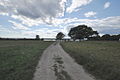 View of Watson Farm down to the shore of Narragansett Bay


See also
Wikimedia Commons has media related to Windmill Hill Historic District.
- Watson Farm, a museum farm operated by Historic New England located in the district
- National Register of Historic Places listings in Newport County, Rhode Island
References
- ^ a b "National Register Information System". National Register of Historic Places. National Park Service. January 23, 2007.
- ^ a b "Windmill Hill Historic District" (PDF). Rhode Island Preservation. Retrieved August 30, 2014.
External links
- Historic American Buildings Survey (HABS) No. RI-394, "Benjamin Carr Farm, Route 138 (Eldred Avenue) & Helm Street, Jamestown, Newport County, RI", 4 photos, 9 data pages, 1 photo caption page
- HABS No. RI-398, "Friends' Burial Ground, Eldred & Beacon Avenues, Jamestown, Newport County, RI", 3 photos, 8 data pages, 1 photo caption page
- HABS No. RI-395, "George C. Carr Farm, Eldred Avenue & North Road, Jamestown, Newport County, RI", 3 photos, 11 data pages, 1 photo caption page
- HABS No. RI-396, "Nicholas Carr Farm, Bounded by North, Weeden, & East Shore Roads, Jamestown, Newport County, RI", 7 photos, 9 data pages, 1 photo caption page
- v
- t
- e
- List of U.S. National Historic Landmarks by state:
- Alabama
- Alaska
- Arizona
- Arkansas
- California
- Colorado
- Connecticut
- Delaware
- Florida
- Georgia
- Hawaii
- Idaho
- Illinois
- Indiana
- Iowa
- Kansas
- Kentucky
- Louisiana
- Maine
- Maryland
- Massachusetts
- Michigan
- Minnesota
- Mississippi
- Missouri
- Montana
- Nebraska
- Nevada
- New Hampshire
- New Jersey
- New Mexico
- New York
- North Carolina
- North Dakota
- Ohio
- Oklahoma
- Oregon
- Pennsylvania
- Rhode Island
- South Carolina
- South Dakota
- Tennessee
- Texas
- Utah
- Vermont
- Virginia
- Washington
- West Virginia
- Wisconsin
- Wyoming
 National Register of Historic Places portal
 Category


This article about a Registered Historic Place in Newport County, Rhode Island is a stub. You can help Wikipedia by expanding it. |
- v
- t
- e


