Willow Metropark


Location within metro Detroit
Willow Metropark is a park in the Huron-Clinton Metroparks system, located on the banks of the Huron River between Lower Huron Metropark to the northwest and Oakwoods Metropark to the southeast. The park consists of a wide variety of trails and recreational areas, including an 18-hole golf course, the 17-acre (69,000 m2) Washago Pond, hike/bike trails, a disc golf course,a children's play area, a pool, and a kayak/canoe launch, in addition to groomed cross country ski trails in the winter months.[1][2][3][4][5]
Bike Trails
In total, approximately 4.5 miles of trails run through the park, all of which are part of the Downriver Linked Greenways System.
- The main route runs primarily along the Huron River, the most direct trail between the entrance to Oakwoods Metropark at the south end of the park and the entrance to Lower Huron Metropark at the opposite end.
- A secondary bypass route begins slightly north of Willow Road, traversing a combination of wooded areas and meadows for about two miles before intersecting the main trail at Washago Pond.
- Two other shorter segments cross the center portion of the park, one of which connects the western bypass trail with the main trail, with the other starting at the bypass trail and running northward into the pool area.
Canoeing and Kayaking

There is one entry point for small crafts on the Huron River, located at the Big Bend picnic area along the main bike route. From here, paddlers can paddle upstream towards Lower Huron Metropark and New Boston or downstream towards Oakwoods Metropark and Flat Rock, though portaging is eventually necessary downstream to get around the Flat Rock Dam.
Gallery
-
 Willow Pool Activity Center
 -
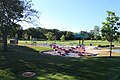 Children's play area
 -
 Food bar
 -
 Picnic Area


References
- ^ "Willow Metropark - Pure Michigan Travel". Michigan.org. 2010-07-28. Retrieved 2012-12-06.
- ^ "Willow Metropark - New Boston, MI - Detroit News". Events.detnews.com. Retrieved 2012-12-06.
- ^ "Willow Metropark in New Boston, MI - Disc Golf Course Review". Dgcoursereview.com. 2012-11-22. Retrieved 2012-12-06.
- ^ "GOLF Magazine's Top 100 Courses in the U.S." GOLF.com. Retrieved 2012-12-06.
- ^ "Willow Metropark in Belleville, MI 48111 | Parents Connect Local". Gocitykids.parentsconnect.com. Retrieved 2012-12-06.
External links
- Huron-Clinton Metroparks
- v
- t
- e
Parks in metropolitan Detroit
- Belle Isle
- Campau Park
- Campus Martius
- Chandler Park
- Clark Park
- Central Park
- Dequindre Cut
- International Riverfront
- Engel Memorial Park
- Ford Park
- Fort Wayne
- Gabriel Richard Park
- Grand Circus
- Howell Park
- Lafayette Park
- Milliken State Park and Harbor
- New Center Park
- Owen Park
- Palmer Park
- Patton Park
- Reid Memorial Park
- Roosevelt Park
- River Rouge Park
- State Fairgrounds
- Three Mile Drive Park
- UIS Irish Plaza
600 to 1,500 acres (243 to 607 ha)
- Addison Oaks
- Algonac State Park
- Belle Isle
- Camp Dearborn
- Crosswinds Marsh
- Hayes State Park (Irish Hills)
- Independence Oaks
- Lower Huron
- Lakeport State Park
- Maybury State Park
- Metamora-Hadley Recreation Area
- Metro Beach Metropark
- Sterling State Park
- Clinton River
- Detroit River (Islands)
- Huron River
- Lake St. Clair
- River Rouge
- St. Clair River
- Belle Isle
- Kensington
- Lakeside Beach and Park
- Lighthouse Beach and Park
- Metro Beach
- Stony Creek
5 to 36 miles (8 to 58 km)
- Bald Mountain
- Detroit River Walk / Dequindre Cut
- Highland Recreation Lakes
- Kensington
- Lakelands Trail State Park
- Novi North Park
- Paint Creek Trail
- Poly Ann Trail
- Pontiac Lake Recreation Area
- Stony Creek Inwood Trails
- Trails in Detroit
- Waterloo-Pinckney Trail
See also Tourism in metropolitan Detroit and Huron–Clinton Metroparks
| ||
|---|---|---|
| Topics |  | |
| Detroit | ||
| Municipalities over 80,000 | ||
| Municipalities 40,000 to 80,000 | ||
| Cultural enclaves | ||
| Satellite cities | ||
| Counties in MSA | ||
| Counties in CSA | ||


 | This Wayne County, Michigan location article is a stub. You can help Wikipedia by expanding it. |
- v
- t
- e


