Wört
You can help expand this article with text translated from the corresponding article in German. (February 2009) Click [show] for important translation instructions.
- View a machine-translated version of the German article.
- Machine translation, like DeepL or Google Translate, is a useful starting point for translations, but translators must revise errors as necessary and confirm that the translation is accurate, rather than simply copy-pasting machine-translated text into the English Wikipedia.
- Do not translate text that appears unreliable or low-quality. If possible, verify the text with references provided in the foreign-language article.
- You must provide copyright attribution in the edit summary accompanying your translation by providing an interlanguage link to the source of your translation. A model attribution edit summary is
Content in this edit is translated from the existing German Wikipedia article at [[:de:Wört]]; see its history for attribution. - You may also add the template
{{Translated|de|Wört}}to the talk page. - For more guidance, see Wikipedia:Translation.
Municipality in Baden-Württemberg, Germany

Coat of arms
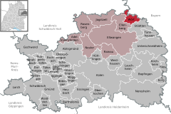
Location of Wört within Ostalbkreis district
(2018–26) Thomas Saur[1]
(2022-12-31)[2]
73499
Wört is a municipality (German: Gemeinde) and town in the district of Ostalbkreis in Baden-Württemberg in Germany.
Geography
Location
Wört is located in the valley of the Rotach, a tributary of the Wörnitz River, in the Virngrund region. It is in the northeastern foothills of the Swabian Alb range, between Dinkelsbühl (6 km) and Ellwangen (13 km).
Neighboring Towns
The municipality is bordered to the north by Fichtenau, part of Schwäbisch Hall district, to the east by the Bavarian city of Dinkelsbühl, to the south by Stödtlen and to the west by Ellenberg.
Land Use
According to the Baden-Württemberg Statistics Office, the total area of the municipality is 18.17 km2 (7.02 sq mi), of which 8.13 km2 (45%) is woodland, 7.67 km2 (42%) is agricultural, 0.9 km2 (5%) is buildings, 0.74 km2 (4%) is for transportation, 0.62 km2 (3.5%) is water and 0.09 km2 (0.5%) is for recreational use.[3]
Notable residents
It is the birthplace of church historian Hubert Wolf (born 1959).
References
- ^ Aktuelle Wahlergebnisse, Staatsanzeiger, accessed 13 September 2021.
- ^ "Bevölkerung nach Nationalität und Geschlecht am 31. Dezember 2022" [Population by nationality and sex as of December 31, 2022] (CSV) (in German). Statistisches Landesamt Baden-Württemberg. June 2023.
- ^ "Fläche seit 1988 nach tatsächlichen Nutzung" (in German). Statistisches Landesamt Baden-Württemberg. 2014. Retrieved 13 Jul 2016.
- v
- t
- e
Towns and municipalities in Ostalb (district)
- Aalen
- Abtsgmünd
- Adelmannsfelden
- Bartholomä
- Böbingen (Rems)
- Bopfingen
- Durlangen
- Ellenberg
- Ellwangen
- Eschach
- Essingen
- Göggingen
- Gschwend
- Heubach
- Heuchlingen
- Hüttlingen
- Iggingen
- Jagstzell
- Kirchheim am Ries
- Lauchheim
- Leinzell
- Lorch
- Mögglingen
- Mutlangen
- Neresheim
- Neuler
- Obergröningen
- Oberkochen
- Rainau
- Riesbürg
- Rosenberg
- Ruppertshofen
- Schechingen
- Schwäbisch Gmünd
- Spraitbach
- Stödtlen
- Täferrot
- Tannhausen
- Unterschneidheim
- Waldstetten
- Westhausen
- Wört

Authority control databases | |
|---|---|
| International |
|
| National |
|
 | This Ostalbkreis location article is a stub. You can help Wikipedia by expanding it. |
- v
- t
- e


