The Preserve
41°19′09″N 72°24′54″W / 41.31917°N 72.41500°W / 41.31917; -72.41500[1]Area 963 acres (390 ha) Elevation 131 ft (40 m)[1] Established 2016 Administrator Connecticut Department of Energy and Environmental Protection and Essex Land Trust Website The Preserve 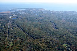
Aerial view of The Preserve and Long Island Sound 
The Preserve is a 963-acre open space preserve spanning the towns of Old Saybrook, Essex, and Westbrook, Connecticut. The property is owned by the State of Connecticut, Town of Old Saybrook, and the Essex Land Trust.[2] It was protected in 2015 by The Trust for Public Land[3][4][5] after an agreement to purchase the property from River Sound Development, LLC, was reached in 2013.[6]
According to the Connecticut Department of Energy and Environmental Protection, The Preserve, prior to its protection, was "the largest remaining unprotected coastal forest between Boston and New York."[2] The Essex Land Trust notes that The Preserve's protected ecosystems include wetlands, vernal pools, and mature coastal forests and that it is home to a diverse population of "25 species of amphibians, 30 kinds of mammals and 57 different birds".[7] It plays an important role in maintaining the water quality of Trout Brook, as well as the Oyster and Mud rivers.[6] Ten miles of hiking trails span northern and central parts of the property.[3]

References
- ^ a b "Pequot Swamp Pond". Geographic Names Information System. United States Geological Survey, United States Department of the Interior.
- ^ a b "The Preserve". State Parks and Forests. Connecticut Department of Energy and Environmental Protection. July 18, 2016. Retrieved April 21, 2018.
- ^ a b Marteka, Peter (April 16, 2016). "The Preserve is officially open for passive recreation". Hartford Courant. Retrieved April 21, 2018.
- ^ Hladky, Gregory B. (September 6, 2014). "Victory came hard in long battle to save The Preserve". Hartford Courant. Retrieved April 21, 2018.
- ^ "The Preserve is permanently protected". The Trust for Public Land. Retrieved April 21, 2018.
- ^ a b "The Preserve". The Trust for Public Land. Retrieved August 3, 2018.
- ^ "The Preserve". Essex Land Trust. Retrieved August 3, 2018.
External links
Wikimedia Commons has media related to The Preserve.
- The Preserve Connecticut Department of Energy and Environmental Protection
- Trail Map The Trust for Public Land
- v
- t
- e
Protected areas of Connecticut
- Appalachian Trail
- New England National Scenic Trail
- Washington–Rochambeau Revolutionary Route
- Above All
- Air Line
- Beaver Brook
- Becket Hill State Park Reserve
- Beckley Furnace Industrial Monument
- Bennett's Pond
- Bigelow Hollow
- Black Rock
- Bluff Point
- Bolton Notch
- Brainard Homestead
- Burr Pond
- Camp Columbia
- Campbell Falls
- Chatfield Hollow
- Collis P. Huntington
- Connecticut Valley Railroad
- Dart Island State Park
- Day Pond
- Dennis Hill
- Devil's Hopyard
- Dinosaur
- Eagle Landing
- Farm River
- Farmington Canal
- Fort Griswold Battlefield
- Fort Trumbull
- Gardner Lake
- Gay City
- George Dudley Seymour
- George Waldo
- Gillette Castle
- Haddam Island
- Haddam Meadows
- Haley Farm
- Hammonasset Beach
- Harkness Memorial
- Haystack Mountain
- Higganum Reservoir
- Hop River State Park Trail
- Hopemead
- Hopeville Pond
- Horse Guard
- Housatonic Meadows
- Humaston Brook
- Hurd
- Indian Well
- John A. Minetto
- Kent Falls
- Kettletown
- Killingly Pond
- Lake Waramaug
- Lamentation Mountain
- Larkin State Park Trail
- Lovers Leap
- Macedonia Brook
- Machimoodus
- Mansfield Hollow
- Mashamoquet Brook
- Mianus River
- Millers Pond
- Minnie Island
- Mohawk Mountain
- Mono Pond
- Moosup Valley State Park Trail
- Mooween
- Mount Bushnell
- Mount Riga
- Mount Tom
- Old Furnace
- Osbornedale
- Penwood
- Platt Hill
- Pomeroy
- Putnam Memorial
- Quaddick
- Quinebaug Lake
- Quinnipiac River
- River Highlands
- Rocky Glen
- Rocky Neck
- Ross Pond
- Salt Rock State Campground
- Satan's Kingdom State Recreation Area
- Scantic River
- Selden Neck
- Seth Low Pierrepont
- Sherwood Island
- Silver Sands
- Sleeping Giant
- Southford Falls
- Squantz Pond
- Stillwater Pond
- Stoddard Hill
- Stratton Brook
- Sunnybrook
- Sunrise
- Talcott Mountain
- Tri-Mountain
- Trout Brook Valley
- Wadsworth Falls
- West Rock Ridge
- Wharton Brook
- Whittemore Glen
- Windsor Locks Canal State Park Trail
- Windsor Meadows
- Wooster Mountain
- Algonquin
- American Legion
- Centennial Watershed
- Cockaponset
- Enders
- James L. Goodwin
- Housatonic
- Massacoe
- Mattatuck
- Meshomasic
- Mohawk
- Mohegan
- Nassahegon
- Natchaug
- Nathan Hale
- Naugatuck
- Nehantic
- Nepaug
- Nipmuck
- Nye-Holman
- Pachaug
- Paugnut
- Paugussett
- People's
- Pootatuck
- Quaddick
- Salmon River
- Shenipsit
- Topsmead
- Tunxis
- Wyantenock
- Aldo Leopold WMA
- Assekonk WMA
- Babcock Pond WMA
- Barber Pond WMA
- Barn Island WMA
- Bartlett Brook WMA
- Bear Hill WMA
- Belding WMA
- Bishops Swamp WMA
- Black Pond WMA
- Candlewood Hill WMA
- Cedar Swamp WMA
- Charles E. Wheeler WMA
- Cromwell Meadows WMA
- Durham Meadows WMA
- East River Marsh WMA
- East Swamp WMA
- Eightmile River WMA
- Franklin Swamp WMA
- Goshen WMA
- Great Harbor WMA
- Higganum Meadows WMA
- Housatonic River WMA
- King's Island Coop WMA
- Kollar WMA
- Larson Lot WMA
- Little River Fish and Wildlife Area
- Lord's Cove WMA
- Maromas Coop WMA
- Meadow Brook WMA
- Menunketesuck WMA
- Messerschmidt WMA
- Newgate WMA
- Nod Brook WMA
- Nott Island WMA
- Pease Brook WMA
- Plum Bank WMA
- Quinebaug River WMA
- Quinnipiac River Marsh WMA
- Ragged Rock WMA
- Raymond Brook Marsh WMA
- Robbins Swamp WMA
- Roger Tory Peterson Wildlife Area
- Roraback WMA
- Rose Hill WMA
- Ross Marsh WMA
- Salmon River Cove and Haddam Neck WMA
- Sessions Woods WMA
- Simsbury WMA
- Skiff Mountain Coop WMA
- James V. Spignesi WMA
- Stanley Works WMA
- Suffield WMA
- Talbot WMA
- Tankerhoosen WMA
- Wangunk Meadows WMA
- Wopowog WMA
- Zemko Pond WMA
- Aspetuck Reservoir
- Barkhamsted Reservoir
- Beaver Dam Lake
- Candlewood Lake
- Easton Reservoir
- Far Mill Reservoir
- Hemlock Reservoir
- Hop Brook Lake
- Lake Lillinonah
- Mansfield Hollow Lake
- Means Brook
- Saugatuck Reservoir
- Trap Falls Reservoir
- West Hartford Reservoir
- West Pequonnock Reservoir
- Lake Zoar
- Aspetuck Land Trust
- Aton Forest
- Audubon Center at Bent of the River
- Bartlett Arboretum and Gardens
- Bear Mountain
- Beckley Bog
- Branford Land Trust
- Case Mountain
- Cathedral Pines
- Connecticut Audubon Society Center at Fairfield
- Connecticut College Arboretum
- Devil's Den Preserve
- Earthplace
- Great Mountain Forest
- Higby Mountain
- Highstead Arboretum
- Joshua's Tract Conservation and Historic Trust
- McLean Game Refuge
- New Canaan Nature Center
- Peter's Rock
- Pine Mountain Reserve
- Saltonstall Mountain
- Stamford Museum & Nature Center
- Steep Rock Association
- Weantinoge Heritage Land Trust
- White Memorial Foundation
- Woodcock Nature Center
- Yale-Myers Forest
- American Legion State Forest Trails
- Aspetuck Valley Trail
- Blue-Blazed Trails
- Chatfield Trail
- Hancock Brook Trail
- Housatonic Range Trail
- Lillinonah Trail
- Mattabesett Trail
- Menunkatuck Trail
- Metacomet Trail
- Narragansett Trail
- Natchaug Trail
- Naugatuck Trail
- Nehantic Trail
- Nipmuck Trail
- Paugussett Trail
- Pequot Trail
- Quinnipiac Trail
- Regicides Trail
- Salmon River Trail
- Shenipsit Trail
- Tunxis Trail
- Westwoods Trails
- Whitestone Cliffs Trail
- Zoar Trail
Forest/Parks
- Bear Mountain Reservation
- Beardsley Park
- Burr Farm Protected Open Space
- East Rock Park
- Gurski Farm Protected Open Space
- Happy Landings Protected Open Space
- Lighthouse Point Park
- Lillinonah Woods
- Mill River Park
- Old Bridge Sanctuary
- Pleasure Beach
- Roosevelt Forest
- Salt Meadow Park
- Seaside Park
- Webb Mountain Discovery Zone
- Webb Mountain Park
| ||
|---|---|---|
|  | |


