Sunshine Mountain
Mountain in the state of Colorado


Sunshine Mountain
Location in Colorado
Show map of Colorado
Sunshine Mountain
Sunshine Mountain (the United States)
Show map of the United StatesColorado, US
San Juan Mountains
Sunshine Mountain is a 12,930-foot-elevation (3,940-meter) mountain summit located in San Miguel County, in Colorado, United States.[3] It is situated nine miles southwest of the community of Telluride, in the Lizard Head Wilderness, on land managed by Uncompahgre National Forest. It is part of the San Juan Mountains which is a subset of the Rocky Mountains. Sunshine Mountain is situated 24 miles west of the Continental Divide, 2.75 miles east of Wilson Peak, and 1.8 mile northeast of Lizard Head, the nearest higher neighbor.[1] Topographic relief is significant as the west aspect rises 2,700 feet (820 meters) above Bilk Creek in approximately one mile. The mountain is composed of rock of the San Juan Formation overlaying Telluride Conglomerate, in turn overlaying Mancos Shale.[4] The mountain's name, which has been officially adopted by the United States Board on Geographic Names, was in use before 1899 when Henry Gannett published it in A Dictionary of Altitudes in the United States.[5]
Climate
According to the Köppen climate classification system, Sunshine Mountain is located in an alpine subarctic climate zone with long, cold, snowy winters, and cool to warm summers.[6] Due to its altitude, it receives precipitation all year, as snow in winter, and as thunderstorms in summer, with a dry period in late spring. Precipitation runoff from the mountain drains into tributaries of the San Miguel River.
Gallery
-
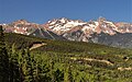
 Sunshine Mountain (left) and Wilson Peak (right) from southbound Highway 145
 -
 Sunshine Mountain (left) and Wilson Peak from the east
 -
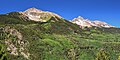
 Sunshine Mountain (left), Mt. Wilson, Wilson Peak
 -
 Lizard Head, Sunshine Mountain, Mt. Wilson, Wilson Peak from Telluride ski area


See also
 Mountains portal
 Colorado portal


- Mountains of San Miguel County, Colorado
References
- ^ a b c "Sunshine Mountain, Colorado". Peakbagger.com.
- ^ a b c "Sunshine Mountain - 12,930' CO". listsofjohn.com. Retrieved 2021-06-29.
- ^ a b "Sunshine Mountain". Geographic Names Information System. United States Geological Survey, United States Department of the Interior. Retrieved 2021-06-29.
- ^ Calvin S. Bromfield, Geology of the Mount Wilson Quadrangle Western San Juan Mountains Colorado, 1967, US Government Printing Office, pages 19, 21
- ^ Henry Gannett, A Dictionary of Altitudes in the United States, 1899, US Government Printing Office, page 97.
- ^ Peel, M. C.; Finlayson, B. L.; McMahon, T. A. (2007). "Updated world map of the Köppen−Geiger climate classification". Hydrol. Earth Syst. Sci. 11. ISSN 1027-5606.
External links
- Weather forecast: Sunshine Mountain
- NGS Data Sheet
- Sunshine Mountain: Alltrails.com
- v
- t
- e

- Mount Garfield
- Aspen Mountain
- Capitol Peak
- Castle Peak
- Cathedral Peak
- Chair Mountain
- Crested Butte
- Gothic Mountain
- Italian Mountain
- Maroon Bells
- Mount Emmons
- Mount Owen
- Mount Sopris
- Pyramid Peak
- Snowmass Mountain
- Snowmass Peak
- Treasure Mountain
- Black Mountain (Moffat County)
- Columbus Mountain
- Elk Mountain (Routt County)
- Hahns Peak
- Flat Top Mountain
- Sleepy Cat Peak
- Eagles Nest
- Jacque Peak
- Meridian Peak
- Mount Powell
- The Spider
- Crater Peak
- North Mamm Peak
- Clark Peak
- Arkansas Hills
- Clinton Peak
- Dyer Mountain
- Gemini Peak
- Horseshoe Mountain
- Mount Arkansas
- Mount Bross
- Mount Buckskin
- Mount Democrat
- Mount Lincoln
- Mount Sheridan
- Mount Sherman
- Pacific Peak
- West Buffalo Peak
- Elk Mountain (Grand County)
- Parkview Mountain
- Radial Mountain
- Whiteley Peak
| Sangre de Cristo Range |
|
|---|---|
| Wet Mountains |
|
| Others |
|
| Collegiate Peaks |
|
|---|---|
| Others |
|
- Crystal Peak
- Fletcher Mountain
- Peak 10
- Peak One
- Quandary Peak
- Tenmile Peak
- Bear Mountain
- Blair Mountain
- Chalk Mountains
- Cochetopa Hills
- Dawson Butte
- Diamond Peak
- Flirtation Peak
- Granite Peak
- Grand Hogback
- Grannys Nipple
- Horsefly Peak
- Lead Mountain (Grand County)
- Mount Neva
- Powell Peak
- San Luis Hills
- Storm King Mountain
- Terrible Mountain
- Two Buttes
- Ute Mountain


