Sint Pieter
Neighborhood in the Netherlands
Neighbourhood and former municipality in Limburg, Netherlands
Sint Pieter | |
|---|---|
neighbourhood and former municipality | |
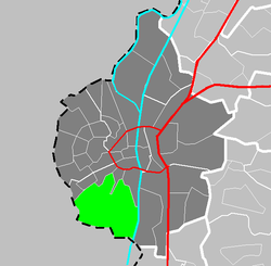 Location of Sint Pieter in Maastricht | |
| Country | Netherlands |
| Province | Limburg |
| Municipality | Maastricht |
| Population | |
| • Total | 158 |
Sint Pieter (Saint Peter) is a neighbourhood in the city of Maastricht, in the Dutch province of Limburg. It is located on the western bank of the river Meuse, in the south of the city, and borders Belgium (both Flanders and Wallonia). It is a relatively affluent neighbourhood.
Sint Pieter used to be a separate village, and was also a separate municipality until it merged with Maastricht in 1920.[1] The municipality covered the village of Sint Pieter and the hill Sint-Pietersberg.
References
- ^ Ad van der Meer and Onno Boonstra, Repertorium van Nederlandse gemeenten, KNAW, 2011.
External links
- Sint Pieter, Maastricht, Netherlands on Google Maps
50°50′N 5°41′E / 50.833°N 5.683°E / 50.833; 5.683
- v
- t
- e
Neighbouring areas
| Biesland Campagne | Jekerdal | Villapark |
 | ||
| Wolder |  Sint Pieter Sint Pieter | Heugem |
 | ||
| Riemst municipality (BE-VLI) (Vroenhoven section) | Riemst municipality (BE-VLI) (Kanne section) | Visé municipality (BE-WLG) (Petit Lanaye section) |
| ||||||||
|---|---|---|---|---|---|---|---|---|
| Culture |
|  | ||||||
| Geography |
| |||||||
| Politics |
| |||||||
| Sports | ||||||||
| Transportation |
| |||||||


 | This Dutch Limburg location article is a stub. You can help Wikipedia by expanding it. |
- v
- t
- e


