Sautens
Place in Tyrol, Austria

Coat of arms

Location in the district
[1]
(2018-01-01)[2]
6432
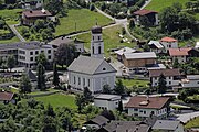
Sautens is a municipality in the Imst district located 9 kilometres (6 mi) southeast of Imst on the lower course of the Ötztaler Ache. The village is located to catch the sun but is protected from the wind, which makes for an especially mild climate. The main source of income is agriculture. Fruit is especially important with a good part of the harvest used to make Schnapps.
The name of the village appears to originate from Roman times. Sautens was once connected with Oetz but became its own community in 1836. Recently the village has experienced increasing tourism.
Population
| Year | Pop. | ±% |
|---|---|---|
| 1869 | 692 | — |
| 1880 | 657 | −5.1% |
| 1890 | 609 | −7.3% |
| 1900 | 559 | −8.2% |
| 1910 | 543 | −2.9% |
| 1923 | 604 | +11.2% |
| 1934 | 650 | +7.6% |
| 1939 | 654 | +0.6% |
| 1951 | 761 | +16.4% |
| 1961 | 792 | +4.1% |
| 1971 | 927 | +17.0% |
| 1981 | 1,081 | +16.6% |
| 1991 | 1,203 | +11.3% |
| 2001 | 1,280 | +6.4% |
| 2011 | 1,417 | +10.7% |
| 2018 | 1,601 | +13.0% |
References
External links
Wikimedia Commons has media related to Sautens.
- v
- t
- e
Municipalities in the district of Imst
- Arzl im Pitztal
- Haiming
- Imst
- Imsterberg
- Jerzens
- Karres
- Karrösten
- Längenfeld
- Mieming
- Mils bei Imst
- Mötz
- Nassereith
- Obsteig
- Oetz
- Rietz
- Roppen
- Sankt Leonhard im Pitztal
- Sautens
- Silz
- Sölden
- Stams
- Tarrenz
- Umhausen
- Wenns
Authority control databases | |
|---|---|
| International |
|
| National |
|
 | This Tyrol location article is a stub. You can help Wikipedia by expanding it. |
- v
- t
- e


