Santanoni Peak
Mountain in New York state, US
- Santanoni is also the name of the Santanoni Preserve, the 13,000-acre (53 km2) once-private preserve that contained Santanoni Peak.


Santanoni Peak
Location of Santanoni Peak within New York
Show map of New York Adirondack Park
Santanoni Peak
Santanoni Peak (the United States)
Show map of the United StatesSantanoni Peak is a mountain located in the Santanoni Range of the Adirondacks in the U.S. state of New York. It is the fourteenth-highest peak in New York, with an elevation of 4,607 ft (1,404 m), and one of the 46 High Peaks in Adirondack Park. It is located in the town of Newcomb in Essex County. Santanoni Peak is flanked to the north by Panther Peak and to the northwest by Couchsachraga Peak, the other two mountains of the Santanoni Range.[5] The mountain's name is believed to be an Abenaki derivative of "Saint Anthony"; the first French fur traders and missionaries having named the area for Saint Anthony of Padua.[4] Two hiking approaches exist to the summit, which allow the mountain to be climbed in a loop with the other peaks of the range. Beginning at a parking lot near the Upper Works trailhead, the Duck Hole via Bradley Pond Trail approaches the mountains. Both approaches to Santanoni Peak branch off of this trail.[6]
Climate
| Climate data for Santanoni Peak 44.0854 N, 74.1311 W, Elevation: 4,222 ft (1,287 m) (1991–2020 normals) | |||||||||||||
|---|---|---|---|---|---|---|---|---|---|---|---|---|---|
| Month | Jan | Feb | Mar | Apr | May | Jun | Jul | Aug | Sep | Oct | Nov | Dec | Year |
| Mean daily maximum °F (°C) | 19.4 (−7.0) | 21.0 (−6.1) | 28.8 (−1.8) | 43.9 (6.6) | 56.5 (13.6) | 64.6 (18.1) | 68.6 (20.3) | 67.2 (19.6) | 61.7 (16.5) | 49.2 (9.6) | 34.1 (1.2) | 24.8 (−4.0) | 45.0 (7.2) |
| Daily mean °F (°C) | 11.0 (−11.7) | 12.5 (−10.8) | 20.4 (−6.4) | 33.8 (1.0) | 46.5 (8.1) | 55.5 (13.1) | 60.0 (15.6) | 58.6 (14.8) | 52.5 (11.4) | 40.5 (4.7) | 27.3 (−2.6) | 17.6 (−8.0) | 36.4 (2.4) |
| Mean daily minimum °F (°C) | 2.6 (−16.3) | 4.0 (−15.6) | 11.9 (−11.2) | 23.8 (−4.6) | 36.6 (2.6) | 46.4 (8.0) | 51.3 (10.7) | 50.0 (10.0) | 43.4 (6.3) | 31.8 (−0.1) | 20.5 (−6.4) | 10.3 (−12.1) | 27.7 (−2.4) |
| Average precipitation inches (mm) | 4.87 (124) | 3.80 (97) | 4.34 (110) | 5.03 (128) | 5.62 (143) | 6.49 (165) | 5.74 (146) | 5.60 (142) | 5.27 (134) | 6.14 (156) | 5.13 (130) | 5.34 (136) | 63.37 (1,611) |
| Source: PRISM Climate Group[7] | |||||||||||||
Gallery
-
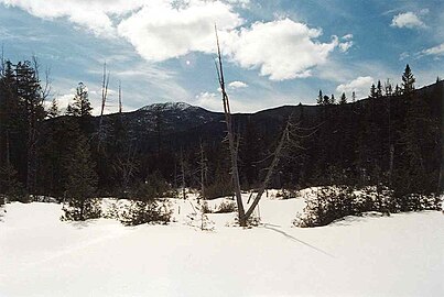 Santanoni Peak seen from Bradley Pond

See also
- List of mountains in New York
- Northeast 111 4,000-footers
- Adirondack High Peaks
- Adirondack Forty-Sixers
External links
- Peakbagger.com: Santanoni Peak
- Summitpost.org: Santanoni Peak
References
- ^ Goodwin, Tony, ed. (2021). Adirondack trails. High peaks region (15th ed.). Adirondack Mountain Club. p. 286. ISBN 9780998637181.
- ^ "The Peaks – Adirondack 46ers". adk46er.org. Retrieved 15 May 2024.
- ^ "Santanoni Peak". Geographic Names Information System. United States Geological Survey, United States Department of the Interior. Retrieved 15 May 2024.
- ^ a b Carson, Russell M. L. (1927). Peaks and People of the Adirondacks. Garden City: Doubleday. pp. 22–26. ISBN 9781404751200.
- ^ Goodwin, Tony, ed. (2021). Adirondack trails. High peaks region (15th ed.). Adirondack Mountain Club. pp. 226–229. ISBN 9780998637181.
- ^ Goodwin, Tony, ed. (2021). Adirondack trails. High peaks region (15th ed.). Adirondack Mountain Club. pp. 226–229. ISBN 9780998637181.
- ^ "PRISM Climate Group, Oregon State University". PRISM Climate Group, Oregon State University. Retrieved October 26, 2023.
To find the table data on the PRISM website, start by clicking Coordinates (under Location); copy Latitude and Longitude figures from top of table; click Zoom to location; click Precipitation, Minimum temp, Mean temp, Maximum temp; click 30-year normals, 1991-2020; click 800m; click Retrieve Time Series button.
- v
- t
- e
The High Peaks of New York's Adirondack Mountains
- Big Slide
- Cascade
- Phelps
- Porter
- Table Top
- Armstrong
- Basin
- Gothics
- Saddleback
- Sawteeth
- Lower Wolfjaw
- Upper Wolfjaw
- Couchsachraga
- Panther
- Santanoni
- Donaldson
- Emmons
- Seward
- Seymour
- (MacNaughton)
- Nye
- Street
 | This article about a location in Essex County, New York is a stub. You can help Wikipedia by expanding it. |
- v
- t
- e


