Ramot Naftali
Place in Northern, Israel
Ramot Naftali רמות נפתלי | |
|---|---|
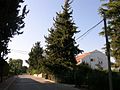
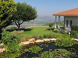 A house in Ramot Naftali with the Hula Valley in the background | |
33°6′6″N 35°33′12″E / 33.10167°N 35.55333°E / 33.10167; 35.55333 | |
| Country | |
| District | Northern |
| Council | Mevo'ot HaHermon |
| Affiliation | Moshavim Movement |
| Founded | 1945 |
| Founded by | Bnei Peled |
| Population (2022)[1] | 551 |
Ramot Naftali (Hebrew: רָמוֹת נַפְתָּלִי) is a moshav in northern Israel. Located in the Upper Galilee near the Lebanese border, it falls under the jurisdiction of Mevo'ot HaHermon Regional Council. In 2022 it had a population of 551.[1]
History
-
 Ramot Naftal 1945
 -
 Ramot Naftal 1945
 -
 Ramot Naftali 1945
 -
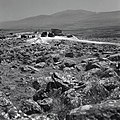
 Ramot Naftali 1947
 -
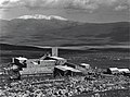 Ramot Naftali with Jebel Sheikh in distance
 -
 Ramot Naftali. April 1948
 -
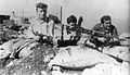 Members of the Yiftach Brigade at Ramot Naftali. 1948
 -
 Israel Air Force plane above Ramot Naftali. 1948


After the 1948 Arab–Israeli War, Ramot Naftali took over part of the land belonging to the newly depopulated Palestinian villages of Qadas[2] and Al-Nabi Yusha'.[3]
Nearby places
Near Ramot Naftali are the following communities: kibbutz Malkia, Kibbutz Yiftah, and moshav Dishon.
The community is located next to Metzudat Koach, a compound of the British Mandate, where 28 fighters were killed when it was captured during the War of Independence.
- Ramot Naftali 1945
-
 Inside of the moshav Ramot Naftali
 -
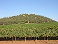 Keren Naftali
 -
 Cattle below Keren Naftali
 -
 View of the Hula national reserve from Keren Naftali


References
- ^ a b "Regional Statistics". Israel Central Bureau of Statistics. Retrieved 21 March 2024.
- ^ Khalidi, Walid (1992). All That Remains: The Palestinian Villages Occupied and Depopulated by Israel in 1948. Washington D.C.: Institute for Palestine Studies. p. 485. ISBN 0-88728-224-5.
- ^ Khalidi, Walid (1992). All That Remains: The Palestinian Villages Occupied and Depopulated by Israel in 1948. Washington D.C.: Institute for Palestine Studies. p. 481. ISBN 0-88728-224-5.
External links
Wikimedia Commons has media related to Ramot Naftali.
- Ramot Naftali Yigal Alon website
- v
- t
- e
- Amnun
- Beit Hillel
- Dishon
- Elifelet
- Kahal
- Margaliot
- Mishmar HaYarden
- Ramot Naftali
- Sde Eliezer
- She'ar Yashuv
- Yuval
Authority control databases | |
|---|---|
| International |
|
| National |
|


