Pacoima Dam
Dam in Los Angeles County, California
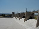
34°20′05″N 118°23′47″W / 34.33472°N 118.39639°W / 34.33472; -118.39639Pacoima Dam is a concrete arch dam on Pacoima Creek in the San Gabriel Mountains, in Los Angeles County, California. The reservoir it creates, Pacoima Reservoir, has a capacity of 3,777 acre⋅ft (4,659,000 m3)[1]
Built by the Los Angeles County Flood Control District, which became part of the Department of Public Works, it was completed in 1928. At the time, the 371 foot (113m) high dam was the tallest arch dam in the U.S.[1]
The dam is situated approximately 1 mile (1.6 km) northeast of Sylmar, above the San Fernando Valley.[1] As a flood control structure, district routinely compensates for hydraulic deficiencies in downstream areas by restraining flows of stormwater released from the dam.[2]
Instrumentation
As construction of Pacoima Dam began, the County of Los Angeles hired Roy W. Carlson[3] as their concrete and soil testing engineer. He developed the world's first strain meter which could be embedded in concrete. He also developed an adiabatic calorimeter and electrical-resistance thermometers to find why the temperature of concrete increased during curing and how best to avoid cracking caused by these stresses.[4]
Earthquake monitoring
The Pacoima Dam withstood, but was damaged by the very strong (>1 g) ground movement which occurred during both the 1971 San Fernando and 1994 Northridge earthquakes. Because of concerns about the stability of the dam and especially its response to potential future earthquakes, the County of Los Angeles, with the technical support of the USGS, began monitoring the dam using continuous GPS.[1]
See also
- Angeles National Forest
- List of dams and reservoirs in California
- List of lakes in California
References
- ^ a b c d Hudnut, Kenneth W. & Behr, Jeffrey A. (1998). "Continuous GPS monitoring of Structural Deformation at Pacoima Dam, California". Seismological Society of America. Retrieved January 23, 2014.
- ^ Sahagún, Louis (March 18, 2023). "Flooding vulnerabilities of L.A. River's Glendale Narrows spark concern amid record rain". Los Angeles Times. Retrieved March 18, 2023.
- ^ Electrical Engineering and Computer Sciences, UC Berkeley "Dr. Roy W. Carlson"
- ^ Rogers, J. David (2012). "DAMS AND DISASTERS: a brief overview of dam building triumphs and tragedies in California's past" (PDF). University of California Davis. Retrieved January 23, 2014.
External links
- Image of workers at the bottom of a canyon at the Pacoima Dam site working on wood framing and concrete pouring, 1926. Los Angeles Times Photographic Archive (Collection 1429). UCLA Library Special Collections, Charles E. Young Research Library, University of California, Los Angeles.
- v
- t
- e
Dams in Los Angeles County, California
- Big Dalton
- Big Tujunga
- Cogswell
- Devil's Gate
- Eaton Wash
- Live Oak
- Morris
- Pacoima
- Puddingstone
- San Dimas
- San Gabriel
- Santa Anita
- Sawpit (disused)
- Sierra Madre
- Thompson Creek
- Baldwin Hills (failed)
- Bouquet
- Chatsworth (unsafe: emptied)
- Dry Canyon (unsafe: emptied)
- Encino
- Fairmont
- Los Angeles
- Mulholland
- Silver Lake
- St. Francis (failed)
- Stone Canyon
- Van Norman (aka San Fernando) (failed)
- Brown Mountain Dam (disused)
- Las Virgenes
- Little Rock
- Rindge (disused)
 | This article about a California building or structure is a stub. You can help Wikipedia by expanding it. |
- v
- t
- e
 | This article about a dam or floodgate in the United States is a stub. You can help Wikipedia by expanding it. |
- v
- t
- e


