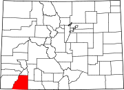
Oxford, Colorado
Unincorporated community in La Plata County, Colorado, United States

Oxford is an unincorporated community in on the Southern Ute Indian Reservation in La Plata County, Colorado, United States.[1]
History
The townsite map was recorded November 3, 1909 by The Oxford Land and Townsite Co. alongside the Denver & Rio Grande RR by J.M. Denning. A post office called Oxford was established in 1908, and remained in operation until 1954.[2] The name Oxford was selected on account of its euphonic sound, according to local history.[3]
See also
 Colorado portal
References
- ^ U.S. Geological Survey Geographic Names Information System: Oxford
- ^ "Post offices". Jim Forte Postal History. Retrieved July 6, 2016.
- ^ Dawson, John Frank. Place names in Colorado: why 700 communities were so named, 150 of Spanish or Indian origin. Denver, CO: The J. Frank Dawson Publishing Co. p. 39.
External links
 Media related to Oxford, Colorado at Wikimedia Commons
- v
- t
- e
Municipalities and communities of La Plata County, Colorado, United States
County seat: Durango
- Durango

- Bayfield
- Ignacio
- Marvel
- Southern Ute
communities
reservations
‡This populated place also has portions in an adjacent county or counties
- Colorado portal
- United States portal
37°10′08″N 107°42′51″W / 37.16889°N 107.71417°W / 37.16889; -107.71417
 | This Colorado state location article is a stub. You can help Wikipedia by expanding it. |
- v
- t
- e


