Outline of North Dakota territorial evolution
Overview of and topical guide to North Dakota territorial evolution

The following outline traces the territorial evolution of the U.S. State of North Dakota.
Outline


- Historical territorial claims of the United Kingdom in the present State of North Dakota:
- Rupert's Land, 1670–1870
- Anglo-American Convention of 1818
- Rupert's Land, 1670–1870
- Historical territorial claims of France in the present State of North Dakota:
- Louisiane, 1682–1764
- Historical territorial claims of Spain in the present State of North Dakota:
- Luisiana, 1764–1803
- Third Treaty of San Ildefonso of 1800
- Luisiana, 1764–1803
- Historical territorial claims of France in the present State of North Dakota:
- Louisiane, 1803
- Vente de la Louisiane of 1803
- Louisiane, 1803
- Historical political divisions of the United States in the present State of North Dakota:
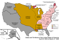
- Unorganized territory created by the Louisiana Purchase, 1803–1804
- District of Louisiana, 1804–1805
- Territory of Louisiana, 1805–1812
- Territory of Missouri, 1812–1821
- Unorganized territory formerly the northwestern Missouri Territory, 1821–1854
- Treaty of Fort Laramie of 1851
- Territory of Michigan east of Missouri River and White Earth River, 1805-(1834–1836)-1837
- Territory of Wisconsin east of Missouri River and White Earth River, (1836–1838)-1848
- Territory of Iowa east of Missouri River and White Earth River, 1838–1846
- Territory of Minnesota east of Missouri River and White Earth River, 1849–1858
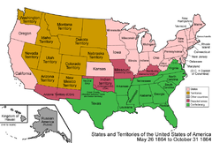
- Territory of Nebraska west of Missouri River or White Earth River, (1854–1861)-1867
- Territory of Dakota, 1861–1889[1]
- State of North Dakota, since November 2, 1889[2]
See also
- Historical outline of North Dakota
- History of North Dakota
- Territorial evolution of the United States
 Territorial evolution of Minnesota
 Territorial evolution of Montana
 Territorial evolution of South Dakota


References
- ^ Thirty-sixth United States Congress (March 2, 1861). "An Act to provide a temporary Government for the Territory of Dakota, and to create the Office of Surveyor General therein" (cgi-bin). Retrieved June 16, 2009.
- ^ Benjamin Harrison (November 2, 1889). "By the President of the United States of America, A Proclamation Admitting the State of North Dakota to the Union". Retrieved June 16, 2009.
External links
- State of North Dakota website
- State Historical Society of North Dakota
- The Themes of North Dakota History
- v
- t
- e
Bismarck (capital)
- Index
- Climate
- Colleges and universities
- Cuisine
- Delegations
- Geography
- Governors
- History
- Islands
- LGBT history
- Music
- People
- Symbols
- Tourist attractions

- Badlands
- Missouri Coteau
- Drift Prairie
- Red River Valley
- Turtle Mountains
pop. over 5,000
pop. 1,000–5,000
- Beach
- Beulah
- Bottineau
- Bowman
- Burlington
- Cando
- Carrington
- Casselton
- Cavalier
- Cooperstown
- Crosby
- Ellendale
- Garrison
- Grafton
- Hankinson
- Harvey
- Hazen
- Hettinger
- Hillsboro
- Horace
- Kenmare
- Langdon
- Larimore
- Lincoln
- Linton
- Lisbon
- Mayville
- New Rockford
- New Town
- Oakes
- Park River
- Rolla
- Rugby
- Stanley
- Thompson
- Tioga
- Velva
- Walhalla
- Washburn
- Watford City
- Wishek
- Adams
- Barnes
- Benson
- Billings
- Bottineau
- Bowman
- Burke
- Burleigh
- Cass
- Cavalier
- Dickey
- Divide
- Dunn
- Eddy
- Emmons
- Foster
- Golden Valley
- Grand Forks
- Grant
- Griggs
- Hettinger
- Kidder
- LaMoure
- Logan
- McHenry
- McIntosh
- McKenzie
- McLean
- Mercer
- Morton
- Mountrail
- Nelson
- Oliver
- Pembina
- Pierce
- Ramsey
- Ransom
- Renville
- Richland
- Rolette
- Sargent
- Sheridan
- Sioux
- Slope
- Stark
- Steele
- Stutsman
- Towner
- Traill
- Walsh
- Ward
- Wells
- Williams
 North Dakota portal
| |
|---|---|
| By country | |
| By former country | |
| By subdivision |
|
| By region |
|
| By country, people, region or period | |
| By international organisation | |
| |


