Oost-Watergraafsmeer
You can help expand this article with text translated from the corresponding article in Dutch. Click [show] for important translation instructions.
- Machine translation, like DeepL or Google Translate, is a useful starting point for translations, but translators must revise errors as necessary and confirm that the translation is accurate, rather than simply copy-pasting machine-translated text into the English Wikipedia.
- Do not translate text that appears unreliable or low-quality. If possible, verify the text with references provided in the foreign-language article.
- You must provide copyright attribution in the edit summary accompanying your translation by providing an interlanguage link to the source of your translation. A model attribution edit summary is
Content in this edit is translated from the existing Dutch Wikipedia article at [[:nl:Oost-Watergraafsmeer]]; see its history for attribution. - You may also add the template
{{Translated|nl|Oost-Watergraafsmeer}}to the talk page. - For more guidance, see Wikipedia:Translation.
Place in Netherlands
Oost-Watergraafsmeer | |
|---|---|
 The Oosterpark | |
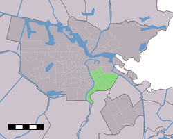 Map of Amsterdam where Oost-Watergraafsmeer is green | |
| Country | Netherlands |
Oost-Watergraafsmeer was a stadsdeel (borough) of Amsterdam until 2010. It bordered Diemen, Duivendrecht, and the boroughs Amsterdam-Centrum, Oud-Zuid, Zeeburg, and Zuideramstel. The Watergraafsmeer part of the borough is a polder.
Located in Oost/Watergraafsmeer:
- Oosterpark
- Science Park Amsterdam
- Buitenplaats Frankendael
References
External links
- Official website
- v
- t
- e


