Oakland Estuary
Strait between Alameda Island and the mainland coast of California, United States
37°47′41.02″N 122°18′54.92″W / 37.7947278°N 122.3152556°W / 37.7947278; -122.3152556
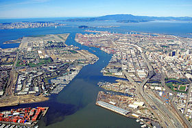
The Oakland Estuary is the strait in the San Francisco Bay Area, California, separating the cities of Oakland and Alameda and the Alameda Island from the East Bay mainland. On its western end, it connects to San Francisco Bay proper, while its eastern end connects to San Leandro Bay.
Early history


3km
2miles
2miles
5
4
3
2
1
Alameda Island and connections:
- Posey and Webster Street tubes
- Park Street Bridge
- Fruitvale Bridge
- High Street Bridge
- Bay Farm Island Bridge
Although the estuary was used by Native American tribes inhabiting the local area since about 4000 BC, the earliest recorded history of the Oakland Estuary dates primarily from events extending back to the 19th century, as detailed in a research study conducted by Earth Metrics for the U.S. Army Corps of Engineers (Earth Metrics, 1990)(Shreffler, 1994). The Oakland Estuary and tributary stream channels were used for shipping transport regularly by the 1850s; early maritime commerce featured movement of lumber and cattle hides. At this time land west of Lake Merritt Slough consisted of undeveloped marshlands. In 1853 the first dredging project of this estuary was initiated,[1] to enable ferry service to San Francisco. By the late 19th century further landside development occurred featuring wharf expansions, railroad service and shipbuilding. The estuary was dredged by the Army Corps of Engineers, making Alameda an island in 1913. Coast Guard Island, originally known as Government Island, was formed in 1913 by the dredging project that extended the Oakland Estuary to San Leandro Bay.
Crossings
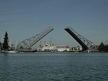
The estuary is spanned by two underwater tubes and three bridges. They are, from west to east:
Facilities
Facilities along the navigable route include the Port of Oakland, Naval Air Station Alameda and Coast Guard Base Alameda located on an island in the strait. Jack London Square is a publicly accessible mixed-use waterfront and marina area where the museum ship, USS Potomac (AG-25), is docked. There are several marinas, some with liveaboards.[2]
 San Francisco Bay Area portal

Further reading
- Historical research of land use and industry in the federal ship channel study area, Oakland, California, Earth Metrics Inc., prepared for and published by the U.S. Army Corps of Engineers, San Francisco District, San Francisco, California (1990)
- Shreffler, D.K., R.M. Tilson, B.I. Wells and J.Q. Word, Tier one ecological evaluation of proposed discharge of dredged materials from the Oakland Harbor to ocean waters , Battelle Marine Sciences Laboratory, prepared for and published by the U.S. Army Corps of Engineers, San Francisco District, San Francisco, California (1994)
References
- ^ Jerrard, Laura, Fruitvale Bay Trail Park: A Feasibility Study and Design Proposal (1997), University of California, Berkeley, p.13.
- ^ Sierra, Stephanie (September 14, 2023). "Coast Guard deploys boats to deter 'pirates' taking over Oakland estuary, officials say". ABC7 San Francisco. Retrieved September 17, 2023.
- v
- t
- e

- Major
- San Francisco Bay
- Suisun Bay
- San Pablo Bay
- Minor
- Golden Gate
- Grizzly Bay
- Richardson Bay
- San Rafael Bay
- Richmond Inner Harbor
- San Leandro Bay
- Former
- Yerba Buena Cove
- Mission Bay
- Rivers
- San Joaquin
- Sacramento
- Napa
- Guadalupe
- Petaluma
- Creeks (discharging into the Bay)
- Alameda
- Baxter
- Cerrito
- Codornices
- Coyote (Santa Clara)
- Coyote (Marin)
- San Leandro
- San Lorenzo
- Schoolhouse
- Temescal
- Sausal
- Redwood
- San Mateo
- Sonoma
- Corte Madera
- Arroyo Corte Madera del Presidio
- San Rafael
- Miller
- Novato
- Tolay
- San Francisquito
- Pacheco
- Alhambra
- Adobe
- Rodeo
- Refugio
- Pinole
- Garrity
- Rheem
- Karlson
- San Pablo
- Castro
- Wildcat
- Fluvius Innominatus
- Marin (Alameda County)
- Strawberry
- Easton
- Mission Creek
- Reservoirs
- Calaveras Reservoir
- Lafayette Reservoir
- Straits and estuaries
- Clifton Court Forebay
- Carquinez Strait
- Oakland Estuary
- Raccoon Strait
- Sacramento–San Joaquin River Delta
- Stockton Deepwater Shipping Channel
- Watersheds
- Laguna Creek Watershed
- Guadalupe watershed
protected areas
- Don Edwards National Wildlife Refuge
- San Pablo Bay National Wildlife Refuge
- Eden Landing Ecological Reserve
- Hayward Regional Shoreline
- Hayward Shoreline Interpretive Center
- Crown Memorial State Beach
- McLaughlin Eastshore State Park
- Emeryville Crescent State Marine Reserve
- Point Isabel Regional Shoreline
- César Chávez Park
- Brooks Island Regional Preserve
- Point Pinole Regional Shoreline
- Antioch Dunes National Wildlife Refuge
- Coyote Point Recreation Area
- Middle Harbor Shoreline Park
- National Estuarine Research Reserve
- China Camp State Park
- San Francisco Maritime National Historical Park
- SF Bay Trail
- Oyster Bay Regional Shoreline
- Big Break Regional Shoreline
- Palo Alto Baylands Nature Preserve
peninsulas
- Major islands
- Alameda
- Alcatraz
- Angel
- Treasure Island
- Yerba Buena
- Minor
- Brooks
- Bair
- Bay Farm
- Belvedere
- Brother
- Castro Rocks
- Coast Guard
- Greco
- Hooks Island
- Mare
- Red Rock
- The Sisters
- Marin Islands
- Roe
- Ryer
- Seal Islands
- Peninsulas/infill
- Albany Bulb
- Brisbane Baylands
- Point Isabel
- Foster City
- Fleming Point
- Hunters Point
- Sierra Point
- Steamboat Point
and tubes
marinas
- History
- Delta and Dawn
- Discovery Site
- Humphrey the Whale
- San Leandro Oyster Beds
- Richmond Shipyards
- U.S. Army Corps of Engineers Bay Model
- Harold Gilliam
- Marincello
- Ecology
- Golden Gate Biosphere Reserve
- Cosco Busan oil spill
- Thicktail chub
- Delta smelt
- Conservation and Development Commission
- The Watershed Project
- Save The Bay
- Citizens for East Shore Parks
- Friends of Five Creeks
- Urban Creeks Council
- 1971 oil spill
- Greenbelt Alliance
- The Bay Institute
- Reber Plan
- San Francisco Baykeeper
- San Francisco Estuary and Watershed Science
- Estuary Partnership
- Transportation
- Water Trail
- Transportation in the San Francisco Bay Area
 Portal
 Category


