National Register of Historic Places listings in Mount Rainier National Park
This is a list of the National Register of Historic Places listings in Mount Rainier National Park.
This is intended to be a complete list of the properties and districts on the National Register of Historic Places in Mount Rainier National Park, Washington, United States. The locations of National Register properties and districts for which the latitude and longitude coordinates are included below, may be seen in a Google map.[1]
There are 44 properties and districts listed on the National Register in the park, four of which are National Historic Landmarks. The entire park has been designated a National Historic Landmark District.
This National Park Service list is complete through NPS recent listings posted September 5, 2024.[2]
Map all coordinates using OpenStreetMap
Download coordinates as:
- KML
- GPX (all coordinates)
- GPX (primary coordinates)
- GPX (secondary coordinates)
Current listings
| [3] | Name on the Register[4] | Image | Date listed[5] | Location | City or town | Description |
|---|---|---|---|---|---|---|
| 1 | Camp Muir |  | March 13, 1991 (#91000176) | Paradise 46°50′07″N 121°43′58″W / 46.835278°N 121.732778°W / 46.835278; -121.732778 (Camp Muir) | Mount Rainier National Park | Also known as Cloud Camp, is on the southeast slope of the mountain, at 10,062 feet (3,067 m). Named for John Muir.[6] |
| 2 | Chinook Pass Entrance Arch |  | March 13, 1991 (#91000202) | Chinook Pass 46°52′20″N 121°30′52″W / 46.872331°N 121.514467°W / 46.872331; -121.514467 (Chinook Pass Entrance Arch) | Mount Rainier National Park | |
| 3 | Christine Falls Bridge |  | March 13, 1991 (#91000196) | Paradise 46°46′51″N 121°46′47″W / 46.780833°N 121.779722°W / 46.780833; -121.779722 (Christine Falls Bridge) | Mount Rainier National Park | |
| 4 | Edith Creek Chlorination House |  | March 13, 1991 (#91000201) | Paradise 46°47′38″N 121°43′54″W / 46.793953°N 121.731644°W / 46.793953; -121.731644 (Edith Creek Chlorination House) | Mount Rainier National Park | |
| 5 | Gobbler's Knob Fire Lookout |  | March 13, 1991 (#91000191) | Nisqually Entrance 46°47′39″N 121°54′48″W / 46.794294°N 121.913375°W / 46.794294; -121.913375 (Gobbler's Knob Fire Lookout) | Mount Rainier National Park | |
| 6 | Huckleberry Creek Patrol Cabin | Upload image | March 13, 1991 (#91000178) | Sunrise 46°59′41″N 121°37′03″W / 46.994842°N 121.617606°W / 46.994842; -121.617606 (Huckleberry Creek Patrol Cabin) | Mount Rainier National Park | |
| 7 | Indian Bar Trail Shelter |  | March 13, 1991 (#91000179) | Paradise 46°49′33″N 121°38′19″W / 46.825819°N 121.638594°W / 46.825819; -121.638594 (Indian Bar Trail Shelter) | Mount Rainier National Park | |
| 8 | Indian Henry's Patrol Cabin |  | March 13, 1991 (#91000180) | Longmire 46°47′39″N 121°50′20″W / 46.794192°N 121.838953°W / 46.794192; -121.838953 (Indian Henry's Patrol Cabin) | Mount Rainier National Park | The structure was stabilized in 1978 with 300 lb (140 kg). footings.[7] |
| 9 | Ipsut Creek Patrol Cabin |  | March 13, 1991 (#91000181) | Carbon River Entrance 46°58′40″N 121°49′54″W / 46.977881°N 121.831694°W / 46.977881; -121.831694 (Ipsut Creek Patrol Cabin) | Mount Rainier National Park | |
| 10 | Lake George Patrol Cabin |  | March 13, 1991 (#91000182) | Longmire 46°47′36″N 121°54′07″W / 46.793372°N 121.901864°W / 46.793372; -121.901864 (Lake George Patrol Cabin) | Mount Rainier National Park | |
| 11 | Longmire Buildings |  | May 28, 1987 (#87001338) | Longmire 46°45′06″N 121°48′42″W / 46.751667°N 121.811667°W / 46.751667; -121.811667 (Longmire Buildings) | Mount Rainier National Park | National Historic Landmark. |
| 12 | Longmire Campground Comfort Station No. L-302 |  | March 13, 1991 (#91000209) | Longmire 46°44′47″N 121°48′41″W / 46.746303°N 121.811442°W / 46.746303; -121.811442 (Longmire Campground Comfort Station No. L-302) | Mount Rainier National Park | |
| 13 | Longmire Campground Comfort Station No. L-303 |  | March 13, 1991 (#91000210) | Longmire 46°44′41″N 121°48′41″W / 46.744861°N 121.811344°W / 46.744861; -121.811344 (Longmire Campground Comfort Station No. L-303) | Mount Rainier National Park | |
| 14 | Longmire Campground Comfort Station No. L-304 | Upload image | March 13, 1991 (#91000211) | Longmire 46°44′36″N 121°48′44″W / 46.74325°N 121.812164°W / 46.74325; -121.812164 (Longmire Campground Comfort Station No. L-304) | Mount Rainier National Park | |
| 15 | Longmire Historic District |  | March 13, 1991 (#91000173) | Longmire 46°44′59″N 121°48′45″W / 46.749722°N 121.8125°W / 46.749722; -121.8125 (Longmire Historic District) | Mount Rainier National Park | |
| 16 | Mount Rainier National Park |  | February 18, 1997 (#97000344) | Longmire 46°52′59″N 121°53′04″W / 46.883056°N 121.884444°W / 46.883056; -121.884444 (Mount Rainier National Park) | Mount Rainier National Park | The park is a National Historic Landmark District, which includes 165 contributing structures and buildings.[8] |
| 17 | Mt. Fremont Fire Lookout | 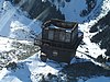 | March 13, 1991 (#91000193) | Sunrise 46°56′03″N 121°40′30″W / 46.934167°N 121.675°W / 46.934167; -121.675 (Mt. Fremont Fire Lookout) | Mount Rainier National Park | |
| 18 | Mowich Lake Patrol Cabin |  | March 13, 1991 (#91000183) | Carbon River Entrance 46°56′05″N 121°51′40″W / 46.9348°N 121.861142°W / 46.9348; -121.861142 (Mowich Lake Patrol Cabin) | Mount Rainier National Park | |
| 19 | Narada Falls Bridge | 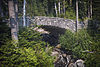 | March 13, 1991 (#91000197) | Paradise 46°46′31″N 121°44′43″W / 46.775292°N 121.745181°W / 46.775292; -121.745181 (Narada Falls Bridge) | Mount Rainier National Park | |
| 20 | Narada Falls Comfort Station | 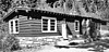 | March 13, 1991 (#91000208) | Paradise 46°46′33″N 121°44′40″W / 46.775825°N 121.744514°W / 46.775825; -121.744514 (Narada Falls Comfort Station) | Mount Rainier National Park | |
| 21 | Nisqually Entrance Historic District | 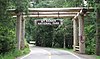 | March 13, 1991 (#91000172) | Nisqually Entrance 46°44′27″N 121°55′09″W / 46.740833°N 121.919167°W / 46.740833; -121.919167 (Nisqually Entrance Historic District) | Mount Rainier National Park | |
| 22 | North Mowich Trail Shelter | Upload image | March 13, 1991 (#91000184) | Mowich Lake Entrance 46°54′55″N 121°53′34″W / 46.915406°N 121.892808°W / 46.915406; -121.892808 (North Mowich Trail Shelter) | Mount Rainier National Park | |
| 23 | Ohanapecosh Comfort Station No. O-302 |  | March 13, 1991 (#91000203) | Ohanapecosh 46°44′13″N 121°33′53″W / 46.736944°N 121.564722°W / 46.736944; -121.564722 (Ohanapecosh Comfort Station No. O-302) | Mount Rainier National Park | |
| 24 | Ohanapecosh Comfort Station No. O-303 |  | March 13, 1991 (#91000204) | Ohanapecosh 46°44′10″N 121°34′01″W / 46.736111°N 121.566944°W / 46.736111; -121.566944 (Ohanapecosh Comfort Station No. O-303) | Mount Rainier National Park | |
| 25 | Paradise Historic District |  | March 13, 1991 (#91000174) | Paradise 46°47′10″N 121°44′07″W / 46.786111°N 121.735278°W / 46.786111; -121.735278 (Paradise Historic District) | Mount Rainier National Park | |
| 26 | Paradise Inn | 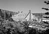 | May 28, 1987 (#87001336) | Paradise 46°47′13″N 121°43′57″W / 46.786944°N 121.732636°W / 46.786944; -121.732636 (Paradise Inn) | Mount Rainier National Park | Opened in 1917, and built in the National Park Service Rustic style of architecture. National Historic Landmark. |
| 27 | Shriner Peak Fire Lookout |  | March 13, 1991 (#91000194) | Ohanapecosh 46°48′50″N 121°31′46″W / 46.813758°N 121.529319°W / 46.813758; -121.529319 (Shriner Peak Fire Lookout) | Mount Rainier National Park | |
| 28 | South Puyallup River Bridge |  | March 13, 1991 (#91000198) | Nisqually Entrance 46°48′29″N 121°53′26″W / 46.808114°N 121.890686°W / 46.808114; -121.890686 (South Puyallup River Bridge) | Mount Rainier National Park | Built in 1931. |
| 29 | St. Andrews Creek Bridge |  | March 13, 1991 (#91000199) | Nisqually Entrance 46°50′10″N 121°54′15″W / 46.836053°N 121.904272°W / 46.836053; -121.904272 (St. Andrews Creek Bridge) | Mount Rainier National Park | Built in 1931. |
| 30 | St. Andrews Patrol Cabin |  | March 13, 1991 (#91000188) | Nisqually Entrance 46°50′10″N 121°54′10″W / 46.836128°N 121.902828°W / 46.836128; -121.902828 (St. Andrews Patrol Cabin) | Mount Rainier National Park | |
| 31 | Summerland Trail Shelter |  | March 13, 1991 (#91000185) | Sunrise 46°51′55″N 121°39′28″W / 46.865372°N 121.6578°W / 46.865372; -121.6578 (Summerland Trail Shelter) | Mount Rainier National Park | |
| 32 | Sunrise Comfort Station | Upload image | March 13, 1991 (#91000207) | Sunrise 46°54′40″N 121°39′32″W / 46.911031°N 121.659011°W / 46.911031; -121.659011 (Sunrise Comfort Station) | Mount Rainier National Park | |
| 33 | Sunrise Historic District | 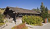 | March 13, 1991 (#91000175) | Sunrise 46°54′53″N 121°38′32″W / 46.914722°N 121.642222°W / 46.914722; -121.642222 (Sunrise Historic District) | Mount Rainier National Park | |
| 34 | Sunset Park Patrol Cabin |  | March 13, 1991 (#91000186) | Mowich Lake Entrance 46°52′58″N 121°53′54″W / 46.882881°N 121.898333°W / 46.882881; -121.898333 (Sunset Park Patrol Cabin) | Mount Rainier National Park | |
| 35 | Sunset Park Trail Shelter | Upload image | March 13, 1991 (#91000187) | Mowich Lake Entrance 46°52′59″N 121°53′49″W / 46.883136°N 121.896883°W / 46.883136; -121.896883 (Sunset Park Trail Shelter) | Mount Rainier National Park | |
| 36 | Tahoma Vista Comfort Station | Upload image | March 13, 1991 (#91000205) | Nisqually Entrance 46°47′43″N 121°52′51″W / 46.795239°N 121.880731°W / 46.795239; -121.880731 (Tahoma Vista Comfort Station) | Mount Rainier National Park | |
| 37 | Three Lakes Patrol Cabin |  | March 13, 1991 (#91000189) | Mt. Rainier National Park 46°45′51″N 121°28′21″W / 46.764167°N 121.4725°W / 46.764167; -121.4725 (Three Lakes Patrol Cabin) | Ohanapecosh | |
| 38 | Tipsoo Lake Comfort Station |  | March 13, 1991 (#91000206) | Chinook Pass 46°52′13″N 121°31′09″W / 46.870319°N 121.519114°W / 46.870319; -121.519114 (Tipsoo Lake Comfort Station) | Mount Rainier National Park | |
| 39 | Tolmie Peak Fire Lookout | 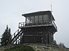 | March 13, 1991 (#91000195) | Mowich Lake Entrance 46°57′28″N 121°52′49″W / 46.957847°N 121.880233°W / 46.957847; -121.880233 (Tolmie Peak Fire Lookout) | Mount Rainier National Park | |
| 40 | White River Bridge | 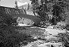 | March 13, 1991 (#91000200) | White River Entrance 46°53′53″N 121°37′04″W / 46.898194°N 121.617861°W / 46.898194; -121.617861 (White River Bridge) | Mount Rainier National Park | |
| 41 | White River Entrance |  | March 13, 1991 (#91000177) | White River Entrance 46°54′09″N 121°33′16″W / 46.9026°N 121.5545°W / 46.9026; -121.5545 (White River Entrance) | Mount Rainier National Park | District consists of 49 acres (20 ha) and three buildings. |
| 42 | White River Mess Hall and Dormitory | 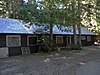 | March 13, 1991 (#91000328) | White River Entrance 46°54′08″N 121°33′16″W / 46.902269°N 121.554339°W / 46.902269; -121.554339 (White River Mess Hall and Dormitory) | Mount Rainier National Park | |
| 43 | White River Patrol Cabin |  | March 13, 1991 (#91000190) | White River Entrance 46°54′10″N 121°38′15″W / 46.902661°N 121.637569°W / 46.902661; -121.637569 (White River Patrol Cabin) | Mount Rainier National Park | |
| 44 | Yakima Park Stockade Group |  | May 28, 1987 (#87001337) | Sunrise (Yakima Park) 46°54′49″N 121°38′32″W / 46.913697°N 121.642347°W / 46.913697; -121.642347 (Yakima Park Stockade Group) | Mount Rainier National Park | Founded c. 1935, the district consists of 35 acres (14 ha), three buildings, one structure, and one object. National Historic Landmark. |
See also
- National Register of Historic Places listings in Lewis County, Washington
- National Register of Historic Places listings in Pierce County, Washington
- List of National Historic Landmarks in Washington (state)
- National Register of Historic Places listings in Washington
References
- Toothman, Stephanie; Begley, Susan; Carr, Ethan. National Register of Historic Places Multiple Property Documentation Form: Mount Rainier National Park. National Park Service 1996 https://npgallery.nps.gov/NRHP/GetAsset/NRHP/64500707_text
- ^ The latitude and longitude information provided in this table was derived originally from the National Register Information System, which has been found to be fairly accurate for about 99% of listings. Some locations in this table may have been corrected to current GPS standards.
- ^ National Park Service, United States Department of the Interior, "National Register of Historic Places: Weekly List Actions", retrieved September 5, 2024.
- ^ Numbers represent an alphabetical ordering by significant words. Various colorings, defined here, differentiate National Historic Landmarks and historic districts from other NRHP buildings, structures, sites or objects.
- ^ "National Register Information System". National Register of Historic Places. National Park Service. April 24, 2008.
- ^ The eight-digit number below each date is the number assigned to each location in the National Register Information System database, which can be viewed by clicking the number.
- ^ Filley 1996, p. 221 harvnb error: no target: CITEREFFilley1996 (help)
- ^ Filley 1996, p. 135 harvnb error: no target: CITEREFFilley1996 (help)
- ^ "Mount Rainier Historic Structures". Retrieved February 23, 2008.
- v
- t
- e
- Longmire Buildings
- Paradise Inn
Landmark District
- Camp Muir
- Chinook Pass Entrance Arch
- Christine Falls Bridge
- Edith Creek Chlorination House
- Gobbler's Knob Fire Lookout
- Huckleberry Creek Patrol Cabin
- Indian Bar Trail Shelter
- Indian Henry's Patrol Cabin
- Ipsut Creek Patrol Cabin
- Lake George Patrol Cabin
- Longmire Campground Comfort Station No. L-302
- Longmire Campground Comfort Station No. L-303
- Longmire Campground Comfort Station No. L-304
- Mt. Fremont Fire Lookout
- Mowich Lake Patrol Cabin
- Narada Falls Bridge
- Narada Falls Comfort Station
- North Mowich Trail Shelter
- Shriner Peak Fire Lookout
- South Puyallup River Bridge
- St. Andrews Creek Bridge
- St. Andrews Patrol Cabin
- Summerland Trail Shelter
- Sunrise Comfort Station
- Sunset Park Patrol Cabin
- Sunset Park Trail Shelter
- Tahoma Vista Comfort Station
- Three Lakes Patrol Cabin
- Tipsoo Lake Comfort Station
- Tolmie Peak Fire Lookout
- White River Bridge
- White River Mess Hall and Dormitory
- White River Patrol Cabin
See also: National Register of Historic Places listings in Mount Rainier National Park
| |
|---|---|
| Topics | |
| Lists by state |
|
| Lists by insular areas | |
| Lists by associated state | |
| Other areas | |
| Related | |
| |


Wikimedia Commons has media related to National Register of Historic Places in Mount Rainier National Park.


