National Register of Historic Places listings in Jefferson County, Mississippi

This is a list of the National Register of Historic Places listings in Jefferson County, Mississippi.
This is intended to be a complete list of the properties and districts on the National Register of Historic Places in Jefferson County, Mississippi, United States. Latitude and longitude coordinates are provided for many National Register properties and districts; these locations may be seen together in a map.[1]
There are 25 properties and districts listed on the National Register in the county.
This National Park Service list is complete through NPS recent listings posted September 13, 2024.[2]
Map all coordinates using OpenStreetMap
Download coordinates as:
- KML
- GPX (all coordinates)
- GPX (primary coordinates)
- GPX (secondary coordinates)
Current listings
| [3] | Name on the Register[4] | Image | Date listed[5] | Location | City or town | Description |
|---|---|---|---|---|---|---|
| 1 | Blantonia Plantation House | Upload image | March 4, 1993 (#93000145) | 3 miles east of Red Lick on an unmarked road off Mississippi Highway 552 31°48′06″N 90°55′55″W / 31.8017°N 90.9319°W / 31.8017; -90.9319 (Blantonia Plantation House) | Lorman | |
| 2 | Cedar Grove Place | Upload image | March 28, 1979 (#79001317) | Mississippi Highway 553 31°42′36″N 91°14′39″W / 31.71°N 91.2442°W / 31.71; -91.2442 (Cedar Grove Place) | Church Hill | |
| 3 | China Grove | Upload image | April 3, 1980 (#80002254) | West of Lorman off U.S. Route 61 31°49′43″N 91°03′50″W / 31.8286°N 91.0639°W / 31.8286; -91.0639 (China Grove) | Lorman | |
| 4 | Christ Church |  | May 6, 1977 (#77000790) | Mississippi Highway 553 31°42′54″N 91°14′17″W / 31.715°N 91.2381°W / 31.715; -91.2381 (Christ Church) | Church Hill | |
| 5 | Church Hill Rural Historic District | Upload image | September 8, 2000 (#00001054) | Mississippi Highway 553 and Church Hill Rd., 1 mile south of Christ Episcopal Church 31°42′27″N 91°14′37″W / 31.7075°N 91.2436°W / 31.7075; -91.2436 (Church Hill Rural Historic District) | Natchez | |
| 6 | Coon Box Fork Bridge | Upload image | May 23, 1979 (#79003429) | Coon Box Rd. 31°47′25″N 91°05′37″W / 31.7903°N 91.0936°W / 31.7903; -91.0936 (Coon Box Fork Bridge) | Coon Box | Destroyed in 2015. |
| 7 | Hays House | Upload image | March 10, 2009 (#09000111) | 18800 U.S. Route 61, S. 31°49′28″N 91°02′54″W / 31.8244°N 91.0482°W / 31.8244; -91.0482 (Hays House) | Lorman | |
| 8 | Hughes-Clark House | Upload image | August 3, 1987 (#87001260) | 221 Poindexter St. 31°42′40″N 91°03′36″W / 31.7111°N 91.06°W / 31.7111; -91.06 (Hughes-Clark House) | Fayette | |
| 9 | Jefferson Chapel A.M.E. Church and Cemetery | Upload image | January 24, 2019 (#100003343) | 291 Chapel Hill Rd. 31°40′45″N 91°14′04″W / 31.6792°N 91.2344°W / 31.6792; -91.2344 (Jefferson Chapel A.M.E. Church and Cemetery) | Natchez | |
| 10 | Laurietta | Upload image | November 24, 1980 (#80002253) | South of Fayette off Mississippi Highway 33 31°40′45″N 91°04′56″W / 31.6792°N 91.0822°W / 31.6792; -91.0822 (Laurietta) | Fayette | |
| 11 | Mud Island Creek Complex (22JE508 and 22JE513) | Upload image | June 29, 1989 (#89000447) | Address restricted[6] | Lorman | |
| 12 | Oak Grove | Upload image | February 22, 1979 (#79001318) | Mississippi Highway 553 31°42′42″N 91°14′22″W / 31.7117°N 91.2394°W / 31.7117; -91.2394 (Oak Grove) | Church Hill | |
| 13 | Old Hill Place Bridge | Upload image | May 23, 1979 (#79003430) | Hill Rd. 31°40′09″N 91°10′52″W / 31.6692°N 91.1811°W / 31.6692; -91.1811 (Old Hill Place Bridge) | Fayette | |
| 14 | Pecan Grove | Upload image | March 13, 1980 (#80002252) | North of Church Hill off Mississippi Highway 553 31°44′06″N 91°13′51″W / 31.735°N 91.2308°W / 31.735; -91.2308 (Pecan Grove) | Church Hill | |
| 15 | Poplar Hill Grade School | Upload image | March 10, 2010 (#10000064) | 3080 Poplar Hill Rd. 31°45′50″N 91°05′37″W / 31.7639°N 91.0936°W / 31.7639; -91.0936 (Poplar Hill Grade School) | Fayette | |
| 16 | Richland | Upload image | July 5, 1984 (#84002227) | Off Mississippi Highway 553 31°45′07″N 91°11′54″W / 31.7519°N 91.1983°W / 31.7519; -91.1983 (Richland) | Church Hill | |
| 17 | Rodney Center Historic District |  | August 29, 1980 (#80002255) | Northwest of Lorman 31°51′40″N 91°11′52″W / 31.8611°N 91.1978°W / 31.8611; -91.1978 (Rodney Center Historic District) | Lorman | |
| 18 | Rodney Presbyterian Church |  | February 6, 1973 (#73001018) | West of Alcorn in the village of Rodney 31°51′46″N 91°11′59″W / 31.8628°N 91.1998°W / 31.8628; -91.1998 (Rodney Presbyterian Church) | Alcorn | |
| 19 | Rosswood | Upload image | December 8, 1978 (#78001606) | East of Lorman on Mississippi Highway 552 31°49′08″N 91°00′43″W / 31.8189°N 91.0119°W / 31.8189; -91.0119 (Rosswood) | Lorman | |
| 20 | Springfield Plantation | 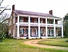 | November 23, 1971 (#71000454) | 8 miles west of Fayette off Mississippi Highway 553 31°44′46″N 91°11′35″W / 31.7461°N 91.1931°W / 31.7461; -91.1931 (Springfield Plantation) | Fayette | Where Andrew Jackson married Rachel Donelson Robards. |
| 21 | Truly House | Upload image | May 13, 2021 (#100006555) | 93 Gilchrist St. Coordinates missing | Fayette | |
| 22 | Union Church Presbyterian Church |  | July 18, 1979 (#79001322) | Mississippi Highway 28 31°40′58″N 90°47′26″W / 31.6828°N 90.7906°W / 31.6828; -90.7906 (Union Church Presbyterian Church) | Union Church | |
| 23 | Woodland Plantation | 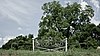 | November 27, 1978 (#78001605) | South of Church Hill on Mississippi Highway 553 31°40′00″N 91°13′54″W / 31.6667°N 91.2317°W / 31.6667; -91.2317 (Woodland Plantation) | Church Hill | |
| 24 | Wyolah Plantation | Upload image | May 30, 1985 (#85001168) | Off Mississippi Highway 553 31°42′10″N 91°14′47″W / 31.7028°N 91.2464°W / 31.7028; -91.2464 (Wyolah Plantation) | Church Hill | |
| 25 | Youngblood Bridge | Upload image | May 23, 1979 (#79003428) | Youngblood Rd. 31°38′00″N 90°48′51″W / 31.6333°N 90.8142°W / 31.6333; -90.8142 (Youngblood Bridge) | Union Church |
Former listings
| [3] | Name on the Register | Image | Date listed | Date removed | Location | City or town | Description |
|---|---|---|---|---|---|---|---|
| 1 | Laurel Hill | Upload image | January 29, 1973 (#73001019) | January 27, 1983 | 2 miles southeast of Rodney | Rodney | Destroyed by fire on November 11, 1982[7] |
See also
Wikimedia Commons has media related to National Register of Historic Places in Jefferson County, Mississippi.
- List of National Historic Landmarks in Mississippi
- National Register of Historic Places listings in Mississippi
References
- ^ The latitude and longitude information provided in this table was derived originally from the National Register Information System, which has been found to be fairly accurate for about 99% of listings. Some locations in this table may have been corrected to current GPS standards.
- ^ National Park Service, United States Department of the Interior, "National Register of Historic Places: Weekly List Actions", retrieved September 13, 2024.
- ^ a b Numbers represent an alphabetical ordering by significant words. Various colorings, defined here, differentiate National Historic Landmarks and historic districts from other NRHP buildings, structures, sites or objects.
- ^ "National Register Information System". National Register of Historic Places. National Park Service. March 13, 2009.
- ^ The eight-digit number below each date is the number assigned to each location in the National Register Information System database, which can be viewed by clicking the number.
- ^ Federal and state laws and practices restrict general public access to information regarding the specific location of this resource. In some cases, this is to protect archeological sites from vandalism, while in other cases it is restricted at the request of the owner. See: Knoerl, John; Miller, Diane; Shrimpton, Rebecca H. (1990), Guidelines for Restricting Information about Historic and Prehistoric Resources, National Register Bulletin, National Park Service, U.S. Department of the Interior, OCLC 20706997.
- ^ "Fire levels historic Laurel Hill". The Clarion-Ledger. November 13, 1982. p. B1. Retrieved July 31, 2022 – via Newspapers.com.
- v
- t
- e
by county
- Adams
- Alcorn
- Amite
- Attala
- Benton
- Bolivar
- Calhoun
- Carroll
- Chickasaw
- Choctaw
- Claiborne
- Clarke
- Clay
- Coahoma
- Copiah
- Covington
- DeSoto
- Forrest
- Franklin
- George
- Greene
- Grenada
- Hancock
- Harrison
- Hinds
- Holmes
- Humphreys
- Issaquena
- Itawamba
- Jackson
- Jasper
- Jefferson
- Jefferson Davis
- Jones
- Kemper
- Lafayette
- Lamar
- Lauderdale
- Lawrence
- Leake
- Lee
- Leflore
- Lincoln
- Lowndes
- Madison
- Marion
- Marshall
- Monroe
- Montgomery
- Neshoba
- Newton
- Noxubee
- Oktibbeha
- Panola
- Pearl River
- Perry
- Pike
- Pontotoc
- Prentiss
- Quitman
- Rankin
- Scott
- Sharkey
- Simpson
- Smith
- Stone
- Sunflower
- Tallahatchie
- Tate
- Tippah
- Tishomingo
- Tunica
- Union
- Walthall
- Warren
- Washington
- Wayne
- Webster
- Wilkinson
- Winston
- Yalobusha
- Yazoo

Municipalities and communities of Jefferson County, Mississippi, United States | ||
|---|---|---|
County seat: Fayette | ||
| City | 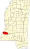 | |
| Unincorporated communities | ||
| Ghost towns | ||
| ||


