Mount Myōjin
Mountain in the country of Japan
34°21′39″N 136°5′42″E / 34.36083°N 136.09500°E / 34.36083; 136.09500Mount Myōjin (明神岳, Myōjin-dake) is a 1,432 m (4,698 ft) mountain, on the border of Matsusaka, Mie and Kawakami, Nara, Japan. This mountain is one of Daikō Mountains.
Routes
There are two major routes to the top of Mount Myōjin. The route from Maakodani Tozanguchi takes about three hours. The other route is via Myōjindaira from Ōmata Bus Stop of Nara Kōtsu. It takes about three and half hours.
Access
- Ōmata Bus Stop of Nara Kōtsu
Gallery
-
 Mount Myōjin from Mount Hinokizuka Okumine (03/2009)
 -
 Mount Myōjin from Mount Azami (03/2009)
 -
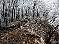
 The top of Mount Myōjin (03/2009)
 -
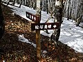
 Myojindaira on the way to Mount Myōjin (03/2009)
 -
 On the way to Mount Myōjin (03/2009)
 -
 A view at Mount Myōjin (03/2009)
 -
 The entrance of a climbing route to Mount Myōjin (03/2009)
 -
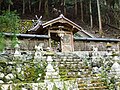 Sasano Shrine at Ōmata (03/2009)


References
- Ōdaigahara, Takami, Kurosoyama, Shobunsha, 2008
- Official Home Page of the Geographical Survey Institute in Japan


