Moldova (river)
River in Romania
You can help expand this article with text translated from the corresponding article in Romanian. (August 2024) Click [show] for important translation instructions.
- Machine translation, like DeepL or Google Translate, is a useful starting point for translations, but translators must revise errors as necessary and confirm that the translation is accurate, rather than simply copy-pasting machine-translated text into the English Wikipedia.
- Do not translate text that appears unreliable or low-quality. If possible, verify the text with references provided in the foreign-language article.
- You must provide copyright attribution in the edit summary accompanying your translation by providing an interlanguage link to the source of your translation. A model attribution edit summary is
Content in this edit is translated from the existing Romanian Wikipedia article at [[:ro:Râul Moldova]]; see its history for attribution. - You may also add the template
{{Translated|ro|Râul Moldova}}to the talk page. - For more guidance, see Wikipedia:Translation.
| Moldova | |
|---|---|
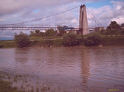
 The Moldova near Gura Humorului | |
 Course of the Moldova (pink) in Romania | |
| Location | |
| Country | Romania |
| Counties | Suceava, Iași, Neamț |
| Towns | Câmpulung Moldovenesc, Roman |
| Physical characteristics | |
| Source | Obcina Feredeu Mountains |
| Mouth | Siret |
• location | near Roman |
• coordinates | 46°54′11″N 26°58′09″E / 46.90306°N 26.96917°E / 46.90306; 26.96917 |
| Length | 213 km (132 mi) |
| Basin size | 4,299 km2 (1,660 sq mi) |
| Discharge | |
| • location | * |
| • average | 32 m3/s (1,100 cu ft/s) |
| Basin features | |
| Progression | Siret→ Danube→ Black Sea |
| Tributaries | |
| • left | Moldovița |
| • right | Neamț |
The Moldova (Romanian: Moldova, pronounced [molˈdova] ⓘ, German: Moldau) is a river in Romania, in the historical region of Moldavia. It is a right tributary of the river Siret.[1][2][3] The river rises from the Obcina Feredeu Mountains of Bukovina in Suceava County and joins the Siret in Cotu Vameș, east of the city of Roman in Neamț County.[4] The total length of the Moldova from its source to its confluence with the Siret is 213 km (132 mi).[2][5][6] Its basin area is 4,299 km2 (1,660 sq mi).[2][5][6]
The river gave its name to the Principality of Moldavia, whose first capital, Târgul Moldovei (now Baia), is on the Moldova River. The etymology of the name is disputed.
Towns and villages
The following towns and villages are situated along the river Moldova, from source to mouth: Moldova-Sulița, Câmpulung Moldovenesc, Vama, Voroneț, Gura Humorului, Păltinoasa, Baia and Roman.
Tributaries
The following rivers are tributaries to the river Moldova (from source to mouth):[2]
Left: Sulița, Benia, Breaza, Pârâul Negru, Moroșani, Pârâul Cailor, Timoi, Sadova, Deia, Lala, Moldovița, Doabra, Beltag, Tocila, Humor, Bucovăț, Corlata, Șomuz, Medisca, Hatia, Lețcani, Cristești, Boura, Petroaia (or Ciohoranca), Valea Baciului, and Ciurlac.
Right: Lucina, Lucava (or Lucova), Tătarca, Răchitiș, Gârbele, Orata, Delnița, Colac, Arseneasca (or Arseneasa), Putna, Colbul (or Izvorul Giumalăului), Prașca, Seaca, Izvorul Alb, Izvorul Malului, Valea Caselor, Șandru, Sălătruc, Suha, Voroneț, Isachia, Bălăcoaia, Valea Seacă, Suha Mică, Suha Mare, Sasca Mare, Bogata, Râșca, Seaca, Râșca, Sărata, Neamț (or Ozana), Topolița, Umbrari, Valea Albă (or Soci), Valea Mare, and Viar.
References
- ^ "Planul național de management. Sinteza planurilor de management la nivel de bazine/spații hidrografice, anexa 7.1" (PDF, 5.1 MB). Administrația Națională Apele Române. 2010. pp. 901–902.
- ^ a b c d Atlasul cadastrului apelor din România. Partea 1 (in Romanian). Bucharest: Ministerul Mediului. 1992. pp. 376–384. OCLC 895459847. River code: XII.1.40
- ^ Ovidiu Gabor - "Economic Mechanism in Water Management" (PDF). Archived from the original (PDF) on 5 March 2009., map page 10
- ^ Moldova, e-calauza.ro
- ^ a b Planul de management al spațiului hidrografic Siret, Administrația Națională Apele Române, page 17
- ^ a b 2017 Romanian Statistical Yearbook, p. 13
Maps
- Maps Munceii Neamțului - Munții Stânișoarei
- Tourist map, Parcul Vânători-Neamț
Authority control databases | |
|---|---|
| International |
|
| National |
|
Portal:
 Romania


