Mbutu Bandarini
National Historic Site of Tanzania
6°52′26.07″S 39°28′18.6″E / 6.8739083°S 39.471833°E / -6.8739083; 39.471833Mbutu Bandarini Ruins(Swahili: Magofu ya mji wa kale wa Mbutu Bandarini) is a Medieval Swahili, National Historic Site located in Somangila ward of Kigamboni District in Dar es Salaam Region of Tanzania. Despite years of indifference that led to vandalism of the site, the Tanzanian government has contracted a firm to begin repair operations as soon as feasible.[2][3]
Site
The site is situated near the Bandarini River delta, close to the seashore, about 2.5 km east of the settlement of Mwongozo in Somangila ward. The site featuring ruined buildings and a mosque's ruins in stones. There is a graveyard and an old well close to the mosque. The mosque at the location is thought to have been constructed during the 14th and 15th centuries A.D. On the surface of the site, there are significant concentrations of native pottery. Chinese celadon from the 15th century, Chinese blue on white, and European porcelain from the 18th century are among the imports found at the location. Heavy layers of indigenous pottery between 0 and 60 cm below the surface were found in a test pit.[4]
Mbutu Bandarini Ruins Gallery
-
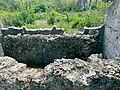 Tomb at Mbutu Bandarini Ruins
 -
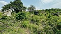 Scene at Mbutu Bandarini Ruins
 -
 Whats left of the old mosque at Mbutu Bandarini Ruins
 -
 Detail of the coral stone that was used to shape the old mosque's mihrab
 -
 Tanzania Forest Service Agency's signage next to the Mbutu Bandarini Ruins.


See also
- Historic Swahili Settlements
- Kaole
- Kunduchi Ruins
- Msuka Mjini Ruins
- Kichokochwe Ruins
- Pujini Ruins
- Kimbiji Ruins
References
- ^ "Antiquities Division". Retrieved 21 Jul 2022.
- ^ "Contract of Restoration of Historical Structures in Kimbiji" (PDF). Retrieved 3 August 2023.
- ^ de Vere Allen, James (1981). "Swahili Culture and the Nature of East Coast Settlement". The International Journal of African Historical Studies. 14 (2): 306–334. doi:10.2307/218047. JSTOR 218047.
- ^ Kessy, Emmanuel (December 1997). "Archaelogical Sites Survey from Kisiju to Dar es Salaam" (PDF). Retrieved 3 August 2023.
{{cite journal}}: Cite journal requires|journal=(help)
- v
- t
- e
Heaquarters: Somangila
- Kimbiji Ruins
- Mbuamaji
- Mbutu Bandarini
- Mwera River
- Ukooni River
- Mbalajangi River
- Mumani River
- Potea River
- Kidete River
- Nguva River
- Pumbweni River
- Mbaranyange River
- Mkomosi River
- Msinga River
- Shungu River
- Kigamboni
| |
|---|---|
| Categories |
|
| Districts | |
| History | |
| Education | |
| Transport | |
| Landmarks | |
| National Parks | |
| |


 | This Tanzania location article is a stub. You can help Wikipedia by expanding it. |
- v
- t
- e


