Mayang Reservoir
Reservoir and Important Bird Area in North Korea
42°04′00″N 129°30′00″E / 42.06667°N 129.50000°E / 42.06667; 129.50000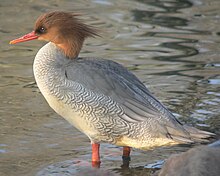
Mayang Reservoir (Korean: 마양저수지Mayangdong-chosuji) is a 376 hectares (930 acres) artificial lake, or reservoir, lying in the mountains of North Hamgyong Province of North Korea at an altitude of 720 metres (2,360 ft) above sea level. It is one of North Korea's designated Natural Monuments and has been identified by BirdLife International as an Important Bird Area (IBA) because it supports a population of endangered scaly-sided mergansers.[1]
References
- ^ "Mayang reservoir". Important Bird Areas factsheet. BirdLife International. 2013. Retrieved 2013-05-06.
- v
- t
- e
Important Bird Areas of North Korea
- Amrok River estuary
- Anbyon Field
- Batoggisem, Dansem and Zamori Islands
- Chongchon River
- Chongdan Field
- Daedong Bay
- Dok-do
- Kangryong Field
- Kumya Bay
- Lake Bujon
- Lake Kwangpo
- Lakes Manpo and Bonpo
- Lake Rangrim
- Lake Samilpo
- Lakes Tungjong and Chonapo
- Mayang Reservoir
- Mount Chilbo
- Mount Kumgang
- Mount Kuwol
- Mount Myohyang
- Mount Oga
- Mount Paekdu
- Oksem, Dongsolbatsem, Sesolbatsem and Namsolbatsem Islands
- Onchon Field
- Ongjin Bay
- Orangchon River estuary
- Panmun Field
- Rab-do and Muki-do Islands
- Ryonghung Gang estuary
- Sogam-do, Daegam-do, Zung-do, Ae-do and Hyengzedo Islands
- Taedong River estuary
- Unmu-do
- Unryul Kumsanpo
 | This North Korea location article is a stub. You can help Wikipedia by expanding it. |
- v
- t
- e


