Maplewood, Wisconsin
Unincorporated community in Wisconsin, United States
44°44′51″N 87°28′45″W / 44.74750°N 87.47917°W / 44.74750; -87.47917 United States
 Wisconsin
54226
Maplewood is an unincorporated community in Door County, in the town of Forestville, Wisconsin, United States. The nearest city to Maplewood is Sturgeon Bay. Maplewood is located along Wisconsin Highway 42 approximately 3 miles (5 km) south of its junction with Wisconsin Highway 57.[2] A small county park in the center of Maplewood provides an eating area and restrooms for users of the Ahnapee State Trail.[3]
Images
-
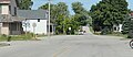 Looking east the main intersection in Maplewood
 -
 Looking east at the sign for Maplewood
 -
 Looking west; postcard dated 1910
 -
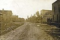 Looking east; postcard dated 1913


References
- ^ U.S. Geological Survey Geographic Names Information System: Maplewood, Wisconsin
- ^ 2001-2002 Official State Highway Map (Wisconsin)
- ^ Interactive map showing how the trail goes through Maplewood. While the map is for the Ice Age Trail, Maplewood is one of the areas where the trails coincide.
- v
- t
- e
Municipalities and communities of Door County, Wisconsin, United States
County seat: Sturgeon Bay

- Baileys Harbor
- Brussels
- Clay Banks
- Egg Harbor
- Forestville
- Gardner
- Gibraltar
- Jacksonport
- Liberty Grove
- Nasewaupee
- Sevastopol
- Sturgeon Bay
- Union
- Washington Island
- Baileys Harbor
- Ellison Bay
- Little Sturgeon
communities
- Brussels
- Carlsville
- Carnot
- Detroit Harbor
- Fish Creek
- Gills Rock
- Idlewild
- Institute
- Jacksonport
- Juddville
- Kolberg
- Maplewood
- Namur
- North Bay
- Northport
- Peninsula Center
- Rosiere‡
- Rowleys Bay
- Salona
- Shoemaker Point
- Valmy
- Vignes
- Washington
- West Jacksonport
- Whitefish Bay
‡Partially located in Kewaunee County
- Wisconsin portal
- United States portal
 | This article about a location in Door County, Wisconsin is a stub. You can help Wikipedia by expanding it. |
- v
- t
- e


